Valentina Rodriguez

Cheapest Countries in South America to Visit


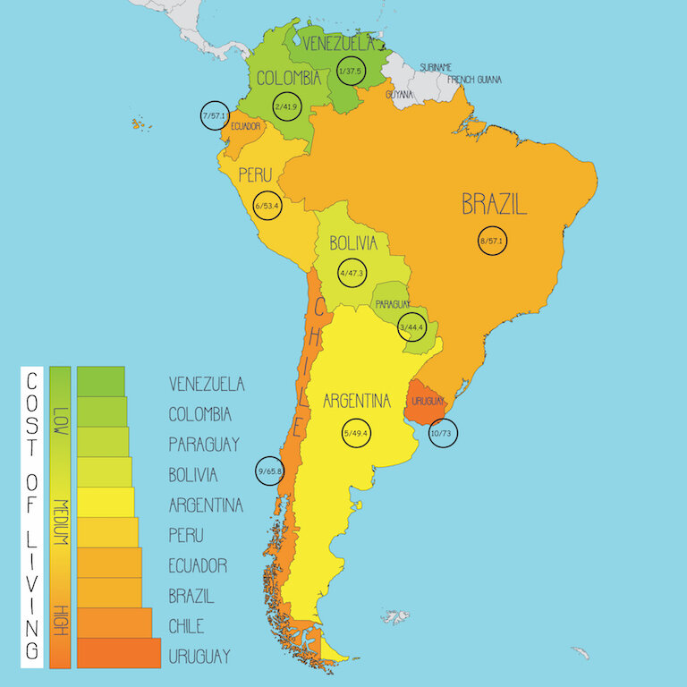
cost of living South America.jpg

“Travel” and “cheap” generally don’t go together. Like most things in life, you get what you pay for. Traveling is no exception.

While countries differ in exchange rates, inflation, cost of living, and purchasing power - contrary to popular belief, there is no country in the world where you can live like Royalty for $100 a day, let alone $10.


Lonely Planet, one of the most respected economical travel guides on the Planet, provides daily budgets for each country. Perú, for example, is budgeted by Lonely Planet at $52 USD per day, which includes:

  1. Sharing a room & bathroom in a hostel

  2. Cooking meals in the hostel kitchen and eating street food

  3. Visiting local, low-key historical sites

What is NOT included in the $52 USD (For the Perú example)

  1. No Alcoholic drinks, such as wine tastings, breweries, nights out, or even just having a casual adult beverage

  2. No tours or major sites (in this Perú example……….no Machu Picchu, Lake Titicaca, or Nazca Lines)

  3. No eloquent/fine dining experiences

  4. No hotel rooms…only shared hostel rooms

  5. No group tours.

    • (Only self-guided tours where you hitch hike to/from attraction)


This article ranks the countries of South America, from cheapest to most expensive, for travelers and tourists. All prices are current as of 2021 and are in United States Dollars (USD).

In addition to my rankings, I have provided Lonely Planet’s budget as a reference point. Along with their mid-range budget, which is more realistic for those looking to visit popular attractions, dine-out, drink, all while still maintaining a relatively frugal budget.


However, keep in mind that if you actually want to travel, and see the famous attractions that motivated you to explore in the first place, that costs money. With that said, I have organized the countries from cheapest to most expensive.


Average Cheapest Daily Cost To Travel by Country (according to Lonely Planet)

PedalChile.Com (Data Sourced from Lonely Planet)
 

Ranking The South American Countries By Travel Costs
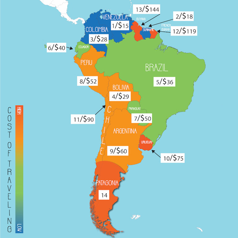
Cheapest countries to budget travel in South America based on Lonely Planet costs. 1 is the cheapest with 14 being most the expensive. The number on the right is the daily cost for budget travel in that respective country (USD).

Cheapest countries to budget travel in South America based on Lonely Planet costs. 1 is the cheapest with 14 being most the expensive. The number on the right is the daily cost for budget travel in that respective country (USD).


Lowest Daily Travel Cost

PedalChile.com (data sourced from Lonely Planet - USA is $150 for comparison)


1) Venezuela (cheapest)


The capital city of Venezuela - Caracas

The capital city of Venezuela - Caracas


Venezuela is not only the cheapest country in South America but it’s one of the cheapest countries you will ever visit, regardless of continent. However, this is assuming you pay with cash and exchange it for the bolívar or US dollars in the black market. If you pay by credit card or use ATMs, you will be charged ruinous official exchange rates.


Venezuela has 43 national parks and over 2,600 km of coastline along the Caribbean coast, with these beaches widely considered the best in South America.
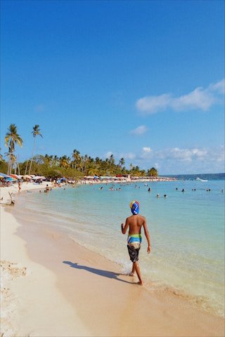
However, Venezuela has the highest rate of inflation in the world, and prices are extremely vulnerable to change. Corruption, crime, civil unrest, inflation, kidnapping, arbitrary arrest, poor health services, and low quality of food, amenities, & services is rampant, which is why Venezuela is generally not talked about when visiting South America and the U.S. State Department says:

“Do not travel to Venezuela due to crime, civil unrest, poor health infrastructure, kidnapping, arbitrary arrest and detention of U.S. citizens, and COVID-19.”


Cheapest daily cost of Venezuela according to Lonely Planet

  • Budget traveler: $15 per person/day (estimated)

  • Budget Lodging = $5

  • Dinner Main = $2

Additional COSTS

  • Coffee at a coffee shop = 1 dollar

  • Beer in a bar = 1.50 to 2 dollars

  • Local dinner = starting at $3

  • Liter of petroleum = 5 cents


2) Suriname

Dutch is the official language in the smallest country in South America, which was a Dutch plantation colony, until gaining its independence in 1975. Most of the country consists of an almost uninhabited intact Amazon jungle where Indigenous tribes still live. It’s no wonder this country is known as “South America’s Wild West.”


The historical district of Paramaribo, the capital and largest city of Suriname

The historical district of Paramaribo, the capital and largest city of Suriname


Unemployment, political instability, and inflation make both Venezuela and Suriname the CHEAPEST COUNTRIES in South America to travel.

  • Both of these countries are in their own budget category as they are significantly cheaper than the rest of South America and are as cheap as any country in the world.


Cheapest daily costs of Suriname according to Lonely Planet

  • Budget traveler: Less than $18

  • Budget hotel room: $10 to $14

  • Chicken & veggie roti: $1.75

*Holiday/party traveler daily cost: $18 to $43


3) colombia


Bogotá, Colombia - The capital and largest city in Colombia is also the most expensive

Bogotá, Colombia - The capital and largest city in Colombia is also the most expensive


Bordering the north-western coasts of South America, Colombia contains many beautiful Caribbean beaches. As well as the capital city of Bogotá, both the vibrant city of Medellin and the beautiful fishing town of Cartagena are well-worth visiting for their sights and atmosphere. However, they are also rather cheap places to visit.

In Colombia, a double room in a mid-priced hotel will typically cost between $25 and $37 per night, and $9 on average for a hostel bed. In terms of food, a three-course meal in a modest restaurant will set you back at around $10 per person.

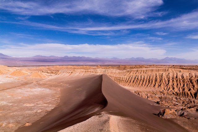
Desierto de la Tatacoa, Colombia


Transport is rather cheap in Colombia, with the eight-hour bus journey between the cities of Bogotá and Salento costing around $16.

Although many of the museums in Medellin are free to enter, some attractions may have an entrance fee of around $5. Other attractions in Colombia may cost more – for example, a paragliding session in San Gil will cost $17 for a short flight, but is definitely worth the price.

  • Group tour of coffee farm = starts at about $50

  • Day tour of Tatacoa Desert = $200+


Cheapest daily cost of Colombia according to Lonely Planet:

  • Budget traveler: Less than $28 per person/day

  • Set meal: $2 to $4

  • Dorm bed: $7 to $13

  • Main dish in decent local restaurant: $5.50 to $8

*Holiday backpacker daily cost: $28 to $70


Medellin, Colombia

Medellin, Colombia


As in every country, the prices can vary dramatically from region to region.

For example, Lonely Planet’s daily cost of Medellín is double that of Colombia in general:

  • Budget traveler: $56 per person/day

  • Dorm bed: $8 to $18

  • Set meal: $3 to $4

  • Beer in a bar: $1.50

*Holiday or party backpacker daily cost: $56 to $97


4) Paraguay


Asunción is Paraguay’s capital and largest city, and also the most expensive city

Asunción is Paraguay’s capital and largest city, and also the most expensive city


Situated in the heart of South America, Paraguay may feel like it is away from the well-trodden tourist track at times, but it is because of this that partly gives the country its charm. It is also rather affordable – although prices for a mid-range hotel room may start at a relatively higher $40 per night, a hostel bed will set you back around $10 per night.

With a three-course meal in a mid-range restaurant priced at around $10 per person, you should be able to get by while traveling the country on a frugal backpacker budget of around $30 each on low-key days.

However, some of the attractions are fairly expensive, with a three-hour private sightseeing tour of Asunción starting at around $60 per person, although the price does include entry to various sites and museums, and a private guide.


Cheapest daily cost of Paraguay according to Lonely Planet:

  • Budget travel: $50 per person/day

  • Bed in a hostel: $12

  • Fast Food meal: $3.75

  • Standard dinner: $12

*Classic Backpacker/Traveler Daily Cost: $50 to $175


5) Bolivia


The Salar de Uyuni, amid the Andes in Bolivia -  the world’s largest salt flat

The Salar de Uyuni, amid the Andes in Bolivia - the world’s largest salt flat


Bolivia is known for having very cheap accommodation and food costs, and is often referred to by travel guides as one of the cheapest, safe countries in South America.

With accommodation costs around $25 per night in a basic hotel, and $14 for a night in a hostel bed, it is the country to visit if you want to save money. Like many South American countries, it has wealthier parts and poorer areas, and it is within relatively poor areas such as Potosi and Oruro where you will find cheaper food and accommodation. Of course, it is often the case that the poorer a neighborhood is, the less safe that it is likely to be.

  • Standard tour of the world's largest salt flat (Salar de Uyuni) for 3 days/2 night = $160

  • Lake Titicaca - between Peru and Bolivia (12,500 feet or 3,808 meters) = One day minimal tour starts at $20


La Paz - Bolivia, is the highest administrative capital in the world at 11,942 feet or 3,640 meters

La Paz - Bolivia, is the highest administrative capital in the world at 11,942 feet or 3,640 meters


Daily cost of Bolivia according to Lonely Planet:

  • Budget travel: $29 per person/day

  • Dorm/budge bed: $6 to $11

  • Simple meal: $7

*Classic party backpacker/traveler daily cost: $29 to $95


6) Argentina


Buenos Aires, Argentina - Argentina’s capital and largest city is also the country’s most expensive. This city is known as the “Paris of the South” for its European style of architecture and legacy

Buenos Aires, Argentina - Argentina’s capital and largest city is also the country’s most expensive. This city is known as the “Paris of the South” for its European style of architecture and legacy


Argentina is the 8th largest country in the world and the most visited country in South America. Buenos Aires, the capital city, is the main entry point for visitors and is home to the Tango dance. Travelers to Buenos Aires will find this city comparable in price to Montreal, Canada.

Argentina is fairly expensive by Latin America standards, as is most of South America, however, Argentina is still cheaper than Brazil, Chile, Uruguay and is comparable to Peru in cost. Like many Latin American countries, the economy is unpredictable, so the Argentine Peso can fluctuate dramatically compared to other currencies.


Daily cost of Argentina according to Lonely Planet:

  • Less than $60 USD per day per person

  • Dorm bed: $15 - 22

  • Cheap main dish: less than $11

*Realistic Backpacker/Traveler Daily Cost: $60 to $200


7) Peru


Street food in Cusco, Perú

Street food in Cusco, Perú


Peru is another rather cheap South American country, with an underrated capital city – Lima – that is significantly cheaper than the large cities of neighboring Brazil. With prices for a standard double hotel room starting at $25 per night (and a hostel bed priced at around $10/night), accommodation costs are rather easy on the wallet. A three-course meal at a mid-range restaurant costs around $8 per person, whereas street food is considerably cheaper.

Travel costs also tend to be rather cheap, with an 18-hour bus ride between the cities of Lima and Cusco starting at $50. Tourist attractions are rather good value for money, with museum entrances within the country being priced at around $10 per ticket.

However, visiting mega tourist attractions, such as Machu Picchu are considerably more expensive:


Cost of Machu Picchu


The Inca ruins of Machu Picchu in Peru

The Inca ruins of Machu Picchu in Peru


  • Machu Picchu entrance tickets ~ $50 each

  • Round trip train ticket from Cuzco to Aguas Calientes (town near Machu Picchu) = $100 minimum

  • Round trip bus ticket from train station to the entrance of the Machu Picchu ruins = $24 each

    • Totaling $174 (minimum) and that’s before lodging, food, taxi ride to train station, travel expenses to Cuzco, tour guides, etc.

Also, keep in mind that prices are much higher for the multi-day Machu Picchu Inca Trail trek – starting at $500 per person – but this is a lifetime experience that you will likely never forget.


Cheapest daily cost of Peru according to Lonely Planet:

  • Budget travel: Less than $52 per day/person

  • Set lunches: Less than $4

  • Bed in dorm or cheap hotel room: $7 to 45 USD

  • Nice dinner: $17+

*Realistic daily traveling cost = $52 to $176


8) Ecuador


Quito, Ecuador (South America)

Quito, Ecuador (South America)


Located on South America’s north-western coast, Ecuador is also known for its rather low accommodation, food and transport costs. Double rooms in a mid-range hotel tend to start at $20 per night, although basic private rooms can cost as little as $15. A night in a hostel bed typically costs around $12.

Food is also generally rather cheap. Being a fairly small and compact country, transport costs are rather low, with a four-hour bus journey from Quito – the country’s capital – to the coastal city of Guayaquil costing around $14.

Attractions also tend to be rather cheap in Ecuador as well. Museum entry fees are typically priced at around $5-10 per person, with hiking trips to volcanoes often starting at around $40 per person. A journey on the amazing Devil’s Nose Train also start at $40 for a ticket.

  • The Galápagos Islands, which is a province of Ecuador, is significantly more expensive than mainland Ecuador

    • Galápagos national park = fee is $100

    • $20 fee when departing the island via airplane


Cheapest daily cost of Ecuador according to Lonely Planet

  • Budget traveler: $40

  • Budget guesthouses: $10–20 per person

  • Set lunches: $2.50–3.50

  • Dinner in good restaurant: $10 to $15 each

*Party/holiday backpacker/traveler daily cost = $40 to $100


9) Brazil


Rio de Janeiro is the second most expensive city in South America and the most expensive city in Brazil. (Brasília is the capital city of Brazil and NOT Rio de Janeiro)

Rio de Janeiro is the second most expensive city in South America and the most expensive city in Brazil. (Brasília is the capital city of Brazil and NOT Rio de Janeiro)


3 of the top 5 most expensive cities in South America are located in Brazil, however, this country is larger than the mainland USA and takes up half of the landmass in South America.

Brazil has an incredibly diverse culture and many famous attractions, such as Iguazu Falls, Christ the Redeemer Statue, Brazilian Carnival, Fernando de Noronha archipelago, and the Amazon Rain Forest.

For budget travelers, the best time to visit Brazil is during the winter, which starts in May and runs to October (seasons reversed in Southern Hemisphere). Brazil has no major festivals during these months and as a result, tourism is at its lowest as are the prices. Rio de Janeiro is always relatively expensive and is similar in costs to those traveling in Toronto (Canada) or Wellington, New Zealand.


Cheapest daily cost of Brazil according to Lonely Planet

  • Budget traveler: Less than $36

  • Dorm Bed: $7 to 15

  • Cheap lunch: Around $3

  • Dinner in average restaurant: $15 to $30 each

*Classic Backpacker/Traveler Daily Cost = $36 to $71


Brasília - capital of Brazil

Brasília - capital of Brazil


Cheapest daily cost of Brasília, Brazil’s capital city, according to Lonely Planet, which is 35% more expensive than Brazil in general:

  • Budget Traveler: $51

  • Double room in a budget hotel: $30 to $34

  • Food court meal: $3.25 to $6

*Classic Backpacker/Traveler Daily Cost = $52 to $103


10) Chile


Santiago, the capital city of Chile and the 3rd most expensive city in South America

Santiago, the capital city of Chile and the 3rd most expensive city in South America


Although Chile is more expensive than nearly every South American country, you will find some parts of the country rather poor, other places (typically toward the south of the country in Patagonia) are relatively modern, remote, and therefore fairly costly and comparable in price to mainstream areas in the United States and Europe.

Although prices for a decent-standard hotel room start at around $40 per night, a hostel bed usually costs within the $6-20 range. Meals are generally more expensive, at around $24 for a three-course meal in a standard restaurant, whereas a six-hour bus journey from Santiago to Concepción costs around $15.

However, bear in mind that Chile is an incredibly long country, extending around 2,600 miles (4,200 km) north to south, so traveling by airplane may be cheaper if you are covering a long distance. Most tourist attractions cost under $10, but the entry fee to some of the more spectacular places – such as the Torres del Paine National Park – will set you back $29 in the high season, and around $15 during the low season.


Cheapest daily cost of Chile according to Lonely Planet

  • Budget traveler: Less than $90 per day/person

  • Cheap Dorm Bed: $13

  • Budget restaurant: Around $7

  • Dinner in decent restaurant: $11 (starting)

*Realistic backpacker/tourist daily cost = $90 to $110


Keep in mind that Chile is the longest country in the world and prices can vary significantly between regions. The daily costs above from Lonely Planet are for Chile in general, below, I have the daily costs for the capital city of Santiago, which are significantly less expensive than Chile’s Patagonia.


Chile - The world’s longest country from North to South

Chile - The world’s longest country from North to South


Cheapest daily cost of SANTIAGO, Chile according to Lonely Planet

  • Budget Travel = $34 per person/day

  • Dorm bed at hostel = $10 to $20

  • Small typical lunch (empanadas) = $2.75

*Classic Backpacker/Traveler Daily Cost = $35 - $103


11) Uruguay

Uruguay is South America’s 2nd smallest, and also the most expensive of the popular tourist countries. Situated between Brazil and Argentina, this country has the lowest rate of poverty and the highest life expectancy in Latin America. The only regions in Latin America that are more expensive to travel, are French Guiana, Guyana, and parts of Patagonia.


Montevideo, Uruguay has the highest cost of living of all South American cities

Montevideo, Uruguay has the highest cost of living of all South American cities


  • Montevideo is the most expensive city in South America and is the only city in the Southern Hemisphere to be among the 100 most expensive cities in the world.

  • Montevideo is comparable in price to Atlanta, Georgia (USA) and is more expensive than Dallas, Texas.

One of the reasons the prices are so high in Uruguay is because Uruguay's sales tax is 22%, compared to 0 - 7.25% in the USA. 

  • Highest sales tax in South America

  • Relatively expensive restaurants

    • Dining out in Uruguay isn’t as expensive as Canada or the United States of America, but it’s the most expensive of any Latin American country at USD 10.50 per person, just for an “inexpensive” meal.

    • The Chivito, Uruguay's classic steak sandwich, and the national dish cost about $10


Cheapest daily cost of Uruguay according to Lonely Planet

  • Budget traveler: Less than $75 per day

  • Dorm Bed: $15 - 35

  • Set price lunch (Menu ejecutivo ): $10 to $15

  • Dinner in a decent restaurant: $25 starting

*Realistic Backpacker/Traveler Daily Cost = $75 to $175


12) French Guiana

French Guiana is an overseas department of France and is a member of the European Union (EU), and as such, its official currency is the Euro, making this French territory, the most expensive region in all of Latin America to live in.

  • French Guiana’s official name is Territorial Collectivity of French Guiana


View from the capital city of Cayenne, French Guiana (Image Source: Wikimedia Commons)

View from the capital city of Cayenne, French Guiana (Image Source: Wikimedia Commons)


This remote department of France is the least visited region in South America. 90% of this territory is inaccessible Amazon jungle. The remaining 10% is an eerie mix of prison-camp history, swamped in rainforest humidity. Add to the mix that this is the most expensive area in Latin America and you get a formula for few visitors.

Emperor Napolean III and subsequent French leaders sent French prisoners here as these prisons were considered escape-proof.


French Guiana is 40% more expensive than France since nearly everything is imported from mainland France.


Cheapest daily cost of French Guiana according to Lonely Planet

  • Budget Traveler: Less than $119

  • Hammock in an open air hut: $12

  • Cheap meal at the central market: $5

*Realistic Backpacker/Traveler Daily Cost = $119 to $209


13) Guyana (most expensive)

One of the least visited but the most expensive country to visit in South America is Guyana. The cost of living here is low, however, the costs to tourists are quite high. This former British colony is the only country in South America with English as the official language and is known for its pristine access to nature and wildlife.


Kaieteur Falls, Guyana (South America) -  Kaieteur is the highest single drop waterfall in the world at 741 feet or 226 meters

Kaieteur Falls, Guyana (South America) - Kaieteur is the highest single drop waterfall in the world at 741 feet or 226 meters


The main reason people come to Guyana is to see Kaieteur Falls, which is the highest single-drop waterfall in the world. The cheapest way to see the falls is by plane and that will set you back about $200 each.

The most affordable lodging in Georgetown (capital) will set you back nearly $30 per night and taking a minibus along the coast starts at ~$45. However, the museums in Georgetown are free.

Both French Guiana and Guyana are expensive. If you are traveling with a budget, you will most likely have to forgo visiting the Guianas.


Cheapest daily cost of Guyana according to Lonely Planet

  • Budget Traveler: $144 per person/day (or less)

  • Budget hotel: $29

  • Decent restaurant meal: $10

    • Street snack: $1

*Realistic Backpacker/Traveler Daily Cost = $144 to $288


Patagonia

It’s impossible to talk about South America without mentioning Patagonia.


Lu (staff member) at Torres del Paine, Chile’s Patagonia

Lu (staff member) at Torres del Paine, Chile’s Patagonia


Even though Patagonia isn’t a country or territory, it’s one of the most visited regions in Latin America. This picturesque area, which is located in both southerly Argentina and Chile is expensive, even by North American and European standards.

One of the reasons that Chile and Argentina’s daily cost is quite high, is due to the high prices of Patagonia. Anything less than $100 per day in this part of the world is just roughing it.


valentina - bio pic copy.jpg

Valentina is a guide for Pedal Chile and is our resident badass. Valentina was born and raised in La Patagonia, which probably explains her affinity for adventuring. Valentina has traveled to over 100 countries and is a native of Chile.

  • Favorite season: Austral Summer


Countries with spiciest food

The Top 11 Countries with the Spiciest Food

Spicy food is popular in many different countries and cultures around the world. Not only do different spices and peppers taste amazing, but many studies have also shown that spicy food can have many health benefits, including reducing the risk of developing cancer and heart disease, helping with weight loss, and possibly improving digestion.

This article lists the 11 countries in the world which have the spiciest food - the data for this article has been sourced from several studies that have researched traditional cookbooks and the amount of capsaicin and piperine in each dish.


Red peppers vary by hotness, depending on the amount of capsaicin in them

Red peppers vary by hotness, depending on the amount of capsaicin in them


In general, capsaicin (from red peppers) and piperine (from black peppers) are the major chemical constituents responsible for the ‘burning’ sensation experienced in your mouth:

  • Capsaicin (from red peppers) gives chili peppers their intensity or “hotness” when ingested or comes in contact with your skin

  • Piperine is the major chemical responsible for the ‘burning’ sensation in black peppers


 11) South Africa

South Africa gained Independence in 1961, after being under the colonial rule of the Dutch, German, French, and British since 1652. Because of this, South Africa cuisine is heavily influenced by various heritages. Today, the food is heavily influenced by India, since during the British colonial rule, many workers came over from India, who brought various spices, which have entered the South African cuisine.

The most commonly used ingredients in cooking are coriander (cilantro), hot peppers, salt, black pepper, anise, garlic, and spices, which is the indication of their Indian influence.


Cape Town - South Africa

Cape Town - South Africa


Local dishes also contain influences from many indigenous southern African cultures alongside European and Asian influences.

A popular spicy food from South Africa is Biltong – thinly-sliced beef or game meat which is cured in a mixture of vinegar, salt and various of spices (often coriander and pepper). Cape Malay curry is rich in cinnamon, turmeric and chili, whereas Chakalaka is a spicy vegetable dish.

However, perhaps the most famous spice used in South African cuisine is peri-peri chili – originally produced by Portuguese explorers, this is rather spicy, and is often served with chicken.


Bunny Chow - South Africa’s National Street Food

Bunny Chow (Image Source)

Bunny Chow (Image Source)

Bunny chow is a hollowed-out loaf of bread filled with spicy curry - vegetable, mutton, or chicken curry can all fill the bowl made of bread. This is the signature dish of Durban and is the original “convenience” or “fast food” of South Africa.


10) China

China is the most ancient living civilization in the world and it’s estimated that the roots of Chinese cuisine date back to the Yangshao Culture, between 5,000 and 3,200 BC. However, prior to 1570, there were zero chili peppers, regardless of variety, anywhere in China.


A tiny section of the Great Wall of China which spans over 13,000 miles (20,000 km)

A tiny section of the Great Wall of China which spans over 13,000 miles (20,000 km)


Before hot chili peppers were brought over to China, the Sichuan Peppercorn, along with ginger, were added to dishes to give it heat. The Sichuan Peppercorn is native to China and is responsible for the numbing sensation it causes around your mouth. Unlike black or red chili peppers, Sichuan Peppercorn is not pungent and doesn’t contain capsaicin or piperine, but rather the molecule hydroxy-alpha-sanshool, which is responsible for the tingling sensation your mouth experiences when consuming it.

Today, Kung pow chicken, dan dan noodles, gan guo, Chuanbei Liangfen, gan bao chicken, kashgar kebabs, mapo doufu, Suan Cai Yu, and saliva chicken, are all examples of extremely spicy Chinese cuisine, many of which feature the Sichuan Peppercorn along with hot chili peppers.


Sichuan-style liangfen. This dish is made with rice or bean noodles and is served cold (Image Source)

Sichuan-style liangfen. This dish is made with rice or bean noodles and is served cold (Image Source)


Sichuan Cuisine

Sichuan cuisine, which is food from the Sichuan Province that borders Tibet, often pairs hydroxy-alpha-sanshool and capsaicin together, creating a synergistic heat effect known as 麻辣 (pronounced má là), meaning “numb” and “spicy.”

This synergistic effect boosts the spicy flavors to the next level as the Sichuan Peppercorn acts differently on our cell’s receptors than capsaicin. However, finding the Sichuan Peppercorn outside of China is rare as many travelers experience “numb tongue” for the first time while visiting the Red Dragon.


Why isn't China higher on this list?

China has over 8,450 distinct dishes with the vast majority of them NOT having any hotness or spice to them. Salt, sugar, and egg are the most commonly used ingredients in China’s every-day diet. Also, China is huge as it even dwarfs the landmass of mainland USA. This large size provides 20 definite regional cuisines using over 2,900 ingredients with only a handful of these that are actually spicy.


9) Mexico

mexican foods.jpg

“In 2010, Mexican food was the first cuisine of a country accepted by the Intergovernmental Committee for the Safe guarding of the Intangible Cultural Heritage of UNESCO in the Representative List of the Intangible Cultural Heritage of Humanity.”

- From the International Journal of Gastronomy and Food Science


Image Source: Cárdenas-Castro et al.

Image Source: Cárdenas-Castro et al.


In Mexico, there are approximate 100 varieties of Chilli Peppers (Capsicum annuum) which are more or less spicy, differing in both size and shape, with colors varying from pale yellow to dark red.

  • 90% of Mexican cuisine is cooked using at least one chili pepper

  • Some varieties: Serrano, jalapeño/chipotle, poblano/ancho, guajillo, pasilla, mulato

With a wide range of different chilies available, including poblano, chipotle, jalapeño and tobasco, Mexican cuisine contains its fair share of spicy, aromatic dishes.

Although traditional Mexican foods and snacks such as tacos, burritos, fajitas and enchiladas can be eaten without much seasoning, different types and levels of chili powder can be added. For example, fajitas can be seasoned in smoky chipotle chili powder, or in spicy garlic powder. Chicken can also be seasoned in different types of chili powder before cooking, and served with black beans and salsa.

Chile peppers originated in Mexico and have been a staple in Mexican cuisine for over 7,000 years. Unlike many other countries, spicy peppers are consumed by all social classes and the ability to handle “heat” has become a cultural trait of Mexicans.


8) Ghana

A beach in Accra - the capital and largest city of Ghana

A beach in Accra - the capital and largest city of Ghana


Spicy food is common in Ghanaian foods. With a cuisine that uses garlic, ginger and pepper, as well as a traditional spicy sauce named ‘Shito’, these spices are often complimented with maize, rice and bean-based foods.

One of the signature dishes of Ghana is a black-eye pea and tomato stew named ‘Red Red’, which is often seasoned with ginger and garlic. Kelewele (spicy plantains) is a fried dish that consists of crispy plantain cubes seasoned in ginger, hot pepper and salt.

Chichinga is a spicy meat skewer common throughout much of western Africa (including Ghana) – it is seasoned in paprika, ginger, cloves and cinnamon.

The Ghanaian believe that hot peppers cool the body and cleanses it of impurities.

7) Thailand

thailand market.jpg

Thailand definitely has its fair share of spicy foods. With many different types of chilies growing within the country, and an abundance of spices such as peppercorn, garlic and ginger, there are plenty of dishes available that incorporate these, including dry curries and soups.

Kua Kling is an incredibly spicy dry curry that contains minced pork and a curry paste made from Thai dried chilies, turmeric, galangal and garlic.


Kua Kling

Kua Kling


Kaeng Tai Pla is an extremely spicy thick soup that includes various herbs and spices including peppercorn and garlic.

Hot sauces are also part of Thailand’s cuisine, including Sriracha – made from red chilies, vinegar and garlic – and Thai sweet chili sauce.

One of the common misconceptions about Thailand is that all food is spicy. Traditional Thai food is all about harmony as hot is balanced with sweet, and sour with savory. Many Thai restaurants abroad over-spice dishes as these establishments attempt to prepare foods that meet people’s “Thai Spice” expectations.


6) Malaysia

Geographically, Malaysia is situated in the South-East Asia separated into two lands by the South China Sea, also known as East Malaysia, and West Malaysia which is part of the Borneo Island.


East and West Malaysia (Image Source)

East and West Malaysia (Image Source)


Like with many countries in south-east Asia, Malaysian food generally has a kick to it, with a fair amount of their dishes being rather spicy.

Three cultures mainly inspire the local cuisine – Malay, Chinese and Indian – bringing in different spicy influences. Sambal Belacan– a spicy chili paste – is a commonly-found condiment that comes with Malay dishes, whereas poultry, meat and seafood are often spiced with herbs including galangal, turmeric, laksa leaves and various types of ginger.

Nasi Lemak – often referred to as Malaysia’s national dish – incorporates Sambal into its recipe. Along with neighboring Indonesia, dishes in Malaysia are also often topped with Gulai, a spicy curry-like sauce that consists of a wide range of spices, including turmeric, coriander, chili pepper and garlic.

Nasi Lemak

Nasi Lemak


5) Indonesia

Number 5 on this list should come as no surprise, considering that the Maluku Islands on the eastern archipelago of Indonesia, are better known as the “Spice Islands.”

  • Christopher Columbus was only about 16,000 miles (25,800 km) off his mark when he floated into the Americas in 1492.

Bandung City, Indonesia

Bandung City, Indonesia


Indonesian food is rather spicy – using chili and other spices in their cooking is just as common as in other parts of south-east Asia.

Rendang is a spicy meat dish that is popular throughout Indonesia, and is infused with an intricate mix of herbs and spices that includes cloves, star anise and cardamom. Bebek Madura is even spicier – this dish consists of tender duck meat seasoned with many different chili types, shallots and pepper.

However, spicier still is Seblak – a popular street food, Seblak is an incredibly spicy meat broth that is flavored with chili, shallots, garlic and kencur (garlic). 

Seblak (Image Source)


4) Ethiopia

Ethiopian food is often rather spicy, and uses a wide range of different spices, including chili powder, garlic, ginger and many types of herbs. Many Ethiopian dishes use a mixture of these ingredients – known as Berbere spices – as a base.


A market in Addis Ababa - Ethiopia’s capital city

A market in Addis Ababa - Ethiopia’s capital city


Tibs is an Ethiopian stir-fry and stew hybrid that includes vegetables, meat and butter, and can range from mildly to incredibly spiced. Ginger, cumin, cloves and chilies are among the spices used for this dish.

Shiro is a spicy stew that consists of powdered chickpeas or broad beans combined with many of the Berbere spices, whereas Messer Wot is an often incredibly spicy lentil dish that includes chili powder, cardamom, cinnamon and garlic.


Mount Abuna Yosef in Ethiopia

Mount Abuna Yosef in Ethiopia


I contacted my friend Amadi, who is from Ethiopia, and this is what he says about Ethiopian cuisine:

Local food of Ethiopia is known for being spicy and tasty.

The level of its spiciness could be to the point were you can’t feel your tongue for a person who haven’t had experience with spice before. Most people say the reason why it’s Spicy is because of the accustom of the natives with spice and low intake of sweets as daily food.

The main ingredient used to make the food spice is called Berbere. Berbere is made up of fine red pepper mixed with some local spices.

The ratio of the mixture must be precise to attain the deliciousness, spice and crisp taste of Berbere. The art of mixing Berbere is so crucial that restaurants use that criteria to hire chiefs.

There is a funny assumption about spices in Ethiopia. Locals believe that eating a spicy food is manly and masculine. In addition to berbere, locals add green Chili to add the food’s spice.

Most dishes in Ethiopia uses Berbere to add spice to the food. Even if the food is made without berbere, adding a powder of berbere as a side meal is a common practice.

Tourists and foreigners find it difficult to cop up with the level of spice in Ethiopian local dishes until they get used to it. After a couple of tries tourists are observed to take some Berbere to their country.

Locals also believe that spicy food is good to health. They believe that it makes you tough and prevent you from diseases.

As an individual I can’t eat any food with out Berber in it. All chicken stew, beef stew, spaghetti uses some pinches of Berbere to add that tongue wrenching taste.

-Amadi


3) India

India, also known as the “Spice Bowl of the World” is well known for cultivating black pepper along with cardamom, nutmeg, ginger, turmeric, and chili peppers.


Spice Usage of Indian Cuisine

Image Source: Sugasini D., et al.


India is a country that is made up of a huge number of different cultures, and its food reflects this rather well. Each region of India contains its own range of spicy dishes – or curries – which often consist of meat or vegetables cooked in a sauce which can vary from incredibly mild through to extremely spicy.


Street vendor in New Delhi, India

Street vendor in New Delhi, India


The more chilies that are added, the spicier the curry will be. Madras and Jalfrezi are two examples of spicy curries, with the former being flavored with large amounts of chili powder, garam masala (a hot spice mix) and cumin. Jalfrezi is a more onion-based dish that also requires a large number of chilies.

However, one of the spiciest Indian dishes is Vindaloo – although it originated in Portugal, Indian chefs in the city of Goa decided to add a great amount of chili powder to this curry, creating a dish that is renowned across the world for its incredible spiciness.


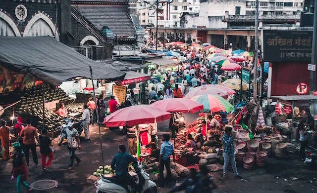
Market in Pune, India

Market in Pune, India


What is Curry?

The word “curry” is a term invented by the Brits when India was under their colonial rule.

  • Curry refers to any meat or vegetable dish cooked in a spiced gravy and served with rice


2) United States of America (Southern States)

Nothing is as American or spicy as eating buffalo wings

Nothing is as American or spicy as eating buffalo wings


The southern states of the USA have a vibrant food culture that generally consists of Native American influences intermingled with dishes specific to European and Mexican communities who have settled in the region over the past few centuries. 

This includes a wide range of spicy foods – this is particularly seen in Tex-Mex cuisine, which borrows from Mexican and Native American food, and commonly uses chilies such as jalapenos and chipotle. 

Examples of Tex-Mex foods include chili con carne, enchiladas, and jalapeno-stuffed beef burgers. Cajun and Creole cuisine are both found in the state of Louisiana and its surrounding area – although these dishes tend not to be chili-based, large amounts of cayenne pepper and extra seasoning are used.

  • Jambalaya, shrimp Creole, Zydeco Chicken, gumbo, and Mardi Gras King Cake are all examples of Creole/cajun dishes.

Buffalo Wings & Spice

Buffalo wings, also called “hot wings” are spicy, seasoned, and deep-fried chicken wings that originated in Buffalo, New York (USA) in the 1960s.

  • Hot wings are traditionally NOT breaded, but instead are tossed into a super-intense spicy sauce and served with celery and blue cheese.

The level of spiciness depends on the establishment, but finding wings served in a Ghost Pepper or Carolina Reaper sauce is easy to find, if you are looking to find some regrettable moments, all done in the name of bragging rights


The Carolina Reaper

The Carolina Reaper - hottest pepper on the planet (Image Source)

The Carolina Reaper - hottest pepper on the planet (Image Source)

USA, home of the spiciest, commercially available chili pepper in the world - the CAROLINA REAPER - was cultivated and developed in South Carolina by American Ed Currie.

  • For comparison, the average Carolina Reaper is 205 times hotter than the hottest varieties of jalapeños.

  • Twice as hot as Ghost peppers (bhut jolokia)


 1) Nigeria

A market in Abeokuta, Nigeria (women selling many different types of peppers)

A market in Abeokuta, Nigeria (women selling many different types of peppers)


Spicy food is popular in Nigerian cuisine, with a fair amount of their dishes using a variety of peppers, including Rodo (Scotch Bonnet) and Shombo (chili pepper). It is particularly popular with the Yoruba peoples, an ethnic group which makes up a significant proportion of the Nigerian population, who believe that eating spicy food improves one’s quality of life.

Suya is a popular spicy Nigerian food – this is a meat skewer which is coated in chili pepper and a variety of additional spices including garlic, cloves and ehuru (nutmeg).

  • Suya is basically a spicy grilled kebab and is the epitome of Nigerian street food, with every town having their favorite local vendor and is usually made with beef, ram, or chicken


A man sells suya in the Asokoro section of Abuja, Nigeria. (Image Source)

A man sells suya in the Asokoro section of Abuja, Nigeria. (Image Source)


Ofada stew is another popular meat dish that is spiced with Rodo peppers and appears in the Western part of Nigeria. This dish gets its name from the local Igbo rice called the ofada rice and is a delicious and spicy Nigerian stew.

Nigerian cooking also produces incredibly spicy sauces and condiments – ata din din sauce is spiced using either Rodo or Shombo pepper varieties, as well as onion and salt. In addition, perhaps the spiciest sauce of them all is Agoyin sauce – made with a large amount of Rodo and Shombo peppers, this is popular in Nigeria, and is known for being extremely spicy.


Spiciest food in the world = Nigeria

The difference between Nigerian cuisine and the dishes of other countries on this list is that nearly ALL Nigerian food is spicy. The Nigerian Pepper is the most used spice and condiment in Nigeria and every Nigerian dish has considerable hotness and “spice” to it.


valentina - bio pic copy.jpg

Valentina is a guide for Pedal Chile and is our resident badass. Valentina was born and raised in La Patagonia, which probably explains her affinity for adventuring. Valentina has traveled to over 100 countries and has eaten food in every country on this list.

  • Favorite season: Austral Summer


More articles from Pedal Chile


References and sources for Countries with Spiciest Foods

  1. Blasi, Abigail. The World’s Best Spicy Food : Where to Find It & How to Make It. Carlton, Vic., Lonely Planet, 2017.

  2. Bosland P. W. (2016). Hot stuff - do people living in hot climates like their food spicy hot or not?. Temperature (Austin, Tex.), 3(1), 41–42. https://doi.org/10.1080/23328940.2015.1130521

  3. Cárdenas-Castro, Alicia Paulina, et al. “Sauces: An Undiscovered Healthy Complement in Mexican Cuisine.” International Journal of Gastronomy and Food Science, vol. 17, Oct. 2019, p. 100154, www.sciencedirect.com/science/article/pii/S1878450X19300137, 10.1016/j.ijgfs.2019.100154.

  4. Harmayani, E., Anal, A.K., Wichienchot, S. et al. Healthy food traditions of Asia: exploratory case studies from Indonesia, Thailand, Malaysia, and Nepal. J. Ethn. Food 6, 1 (2019). https://doi.org/10.1186/s42779-019-0002-x

  5. HAO, Chao-yun, et al. “Modeling the Potential Geographic Distribution of Black Pepper (Piper Nigrum) in Asia Using GIS Tools.” Journal of Integrative Agriculture, vol. 11, no. 4, Apr. 2012, pp. 593–599, 10.1016/s2095-3119(12)60046-x.

  6. Ivonne Guadalupe Troconis-Torres, Marlon Rojas-López, César Hernández-Rodríguez, Lourdes Villa-Tanaca, Ignacio Eduardo Maldonado-Mendoza, Lidia Dorantes-Álvarez, Darío Tellez-Medina, María Eugenia Jaramillo-Flores, "Biochemical and Molecular Analysis of Some Commercial Samples of Chilli Peppers from Mexico", BioMed Research International, vol. 2012, Article ID 873090, 11 pages, 2012.

  7. Oktay, Serdar, and Saide Sadıkoğlu. “The Gastronomic Cultures’ Impact on the African Cuisine.” Journal of Ethnic Foods, vol. 5, no. 2, June 2018, pp. 140–146, 10.1016/j.jef.2018.02.005.

  8. Paul W. Sherman, Jennifer Billing, Darwinian Gastronomy: Why We Use Spices: Spices taste good because they are good for us, BioScience, Volume 49, Issue 6, June 1999, Pages 453–463, https://doi.org/10.2307/1313553

  9. Sei, Yoshinobu. “Indian Cuisine and Umami.” Food Reviews International, vol. 14, no. 2-3, May 1998, pp. 269–271, 10.1080/87559129809541161.

  10. Sherman, Paul W, and Geoffrey A Hash. “Why Vegetable Recipes Are Not Very Spicy.” Evolution and Human Behavior, vol. 22, no. 3, May 2001, pp. 147–163, 10.1016/s1090-5138(00)00068-4.

  11. Sugasini D., et al. “Indian Culinary Ethnic Spices Uses in Foods are Palate of Paradise”. Acta Scientific Nutritional Health 2.8 (2018): 22-28

  12. Tamang, Jyoti Prakash. “Indian Dietary Culture.” Journal of Ethnic Foods, vol. 3, no. 4, Dec. 2016, pp. 243–245, 10.1016/j.jef.2016.11.005.

  13. Zhu, Yu-Xiao, et al. “Geography and Similarity of Regional Cuisines in China.” PLoS ONE, vol. 8, no. 11, 18 Nov. 2013, p. e79161, 10.1371/journal.pone.0079161.


Do They Speak Spanish in Brazil


Bem-Vindo means “welcome” in Brazilian Portuguese

Bem-Vindo means “welcome” in Brazilian Portuguese


Surrounded by many countries, the majority of which speak dialects of Spanish, Brazil is unusual in that it is the only Portuguese-speaking country within the entirety of the Americas.

The vast majority of the country’s 210 million people speaks a dialect of Portuguese – simply known as Brazilian Portuguese – as a first language.


Brazilian Portuguese is the national and OFFICIAL language of Brazil and is spoken by 99% of the population.

  • Brazilian Portuguese is distinct from European Portuguese with significant differences in pronunciation and vocabulary.

 
Brazil language.jpg
 

Brazil & Languages

A wide range of other languages are used within the country, which is not surprising as Brazil is a rather multicultural country that covers a vast land area. The list of languages that are spoken includes many indigenous languages. In addition, although many people emigrated to Brazil from Portugal, a great deal also settled in the country from other European countries, bringing with them a wide range of other minority languages, including German and Italian.

Spoken by 99 percent of the population, Brazilian Portuguese is by far the majority language in Brazil. It is used in almost all schools and media outlets in the country, as well as in government, administrative and business settings.

Why Do Brazilians Speak Portuguese and not Spanish?

Although most of South America was colonized by the Spanish, the Portuguese colonized Brazil in the 1500s. During this time, most Brazilians spoke a language called Tupi. The Portuguese banned Tupi in the mid-1700s, however, many of these words made their way into Brazilian Portuguese.


Pedro Álvares Cabral (Image Source: Wikimedia Commons)

Pedro Álvares Cabral (Image Source: Wikimedia Commons)

However, this is just the short answer as the real story is much longer and more complex. When Pedro Álvares Cabral reached the Brazilian coast on April 22nd, 1500, there was more than 1,200 native indigenous spoken languages. Until the mid-18th century, Portuguese was spoken only in the coastal areas.

In 1757, a law was passed, called the Directory of the Indians’ (Diretório dos índios’) which prohibited the natives from speaking/learning their mother tongue and established Portuguese as the one and only language of Brazil.

By the year 2000, only about 170 indigenous languages have survived, mostly in the most remote places of the Amazon rainforest.


Rio de Janeiro, Brazil (South America)

Rio de Janeiro, Brazil (South America)


Brazilian vs European Portuguese

The Portuguese spoken in Brazil today is markedly different from that spoken in Portugal. The vocabulary, syntax, and pronunciation differs significantly, and the difference is greater than the one between British and American English.

Both Brazil and Portugal have undergone spelling reforms since the 16th Century, and the pronunciation and meaning of many of the words have changed so much that it is sometimes easier for Brazilian people to understand the Spanish that is spoken in Latin American countries than the language of Portugal. Furthermore, some of the grammar structures are rather different in both countries.


Ordem e Progresso means “Order and Progress”

Ordem e Progresso means “Order and Progress”


Some linguists say the differences between European and Brazilian Portuguese are so huge that Brazilian Portuguese shouldn’t even be called Portuguese but instead Brazilian.


Loan Words & Language

Immigrants from other European countries – in particular Spain, Italy and Germany – and from Asian countries such as Japan, have added many loanwords to the Brazilian Portuguese dictionary that would confuse a native speaker in Portugal.

It is also estimated that over a thousand words and phrases have entered Brazilian Portuguese from the many indigenous languages that already existed before the Portuguese merchants settled in South America, thereby influencing the language so that it diverges even further from standard Portuguese.

These include the name for indigenous flora and fauna, as well as many place names and natural features in Brazil.

Minority Languages & Brazil

There are many minority languages which are spoken in Brazil alongside Portuguese. According to the 2010 Census, 274 of these are spoken by indigenous peoples, who often reside in remote rainforest areas across the northern half of the country.

The largest languages are Tikuna, with 35,000 speakers, Guarani Kaiowá (spoken by 26,500 people) and Kaingang (with 22,000 speakers). Moreover, a total of nine indigenous languages are spoken by more than 10,000 people. Some of these are protected by the Brazilian government – for example, Tikuna was used by governmental campaigns for the prevention of AIDS and violence against women.

Tikuna is also taught to children in their local community alongside Brazilian Portuguese. However, despite these efforts, many of the indigenous languages are on the verge of extinction, and it is estimated that a third may die out by 2030.


Due partially from Brazil’s massive size, there are 16 major Brazilian Portuguese dialects

Due partially from Brazil’s massive size, there are 16 major Brazilian Portuguese dialects


The Spanish Language in Brazil

In terms of European languages, Spanish is – perhaps surprisingly – spoken by only 460,000 people in the country. This is because many Spanish immigrants largely assimilated when they emigrated to Brazil, and their children mainly lost the native tongue of their parents.


Iguazú Falls on the Argentina/Brazil border.

Iguazú Falls on the Argentina/Brazil border.


Spanish & Portuguese: Similar but Different

This is perhaps understandable because – even though there are marked differences between Spanish and Portuguese – the two languages are fairly similar to one another, making picking up Portuguese easier for a Spanish person than it would be for someone from Germany.

In the areas of Brazil that border Spanish-speaking countries (which is almost the entire border), a pidgin language called ‘Portunhol’ has emerged, which more or less blends the two languages together.

More commonly spoken languages that were brought in by Europeans include German and Italian – generally concentrated in the southern and south-eastern parts of the country, dialects of these languages are spoken quite widely. Three-million Brazilians speak a German dialect named ‘Hunsrik’, whereas 1-million speak a variation of Italian that is referred to as ‘Brazilian Venetian’.

Hunsrik: 2nd Most Spoken Language in Brazil

Hunsrik is the second-most spoken first language in Brazil, with some municipalities in the extreme south of the country recognizing both the German dialect and Brazilian Portuguese as official languages in local areas.

Other minority languages include Japanese, with a small but close-knit Japanese community being located in São Paulo, as well as other small communities that speak a number of other languages including Catalan, Polish and Dutch.

Bottom Line

Although the vast majority of Brazilian people speak Portuguese, it is important to acknowledge that there is a wide range of minority languages spoken throughout the country.

Although a small minority do not speak Brazilian Portuguese, or have a limited understanding of it, many speakers of the minority languages speak Portuguese alongside their own language. The wide range of other languages used within the country only emphasizes that Brazil is a rather multicultural nation.


valentina - bio pic copy.jpg

Valentina is a guide for Pedal Chile and is our geology expert. Valentina has been in love with geology ever since she first saw Villarrica glowing in her native country of Chile. Valentina was born and raised in La Patagonia, which probably explains her affinity for adventuring. When Valentina isn’t crushing some poor dude’s soul, you can find her shredding down Rucapillán. Favorite season: Austral Summer


References and Sources

  1. Babbel.com, and Lesson Nine GmbH. “Which Are the Most Spoken Languages in Brazil?” Babbel Magazine, 2017.

  2. Braz, Rodrigo. “Fact Sheet.” Brazil, 23 Jan. 2018, www.brazil.gov.br/about-brazil/fact-sheet.

  3. Hengeveld, Kees, and Marize Mattos Dall’Aglio Hattnher. “Four Types of Evidentiality in the Native Languages of Brazil.” Linguistics, vol. 53, no. 3, 1 Jan. 2015, 10.1515/ling-2015-0010.

  4. Joseolgon. “English: Azulejos of Pedro Alvares Cabral, in Centro Cultural Rodrigues de Faria, Forjães, Esposende, Portugal, from Jorge Colaço.” Wikimedia Commons, 30 Oct. 2009, commons.wikimedia.org/wiki/File:Pedro_Alvares_Cabral.JPG.

  5. Limberger, Bernardo K., et al. “Phonemic Awareness in an Oral German-Origin Brazilian Language: A Study of Hunsrückisch and German Bilinguals.” Ilha Do Desterro a Journal of English Language, Literatures in English and Cultural Studies, vol. 72, no. 3, 7 Oct. 2019, pp. 427–445, 10.5007/2175-8026.2019v72n3p427.

  6. ‌Massini-Cagliari, Gladis. “Language Policy in Brazil: Monolingualism and Linguistic Prejudice.” Language Policy, vol. 3, no. 1, 2004, pp. 3–23, 10.1023/b:lpol.0000017723.72533.fd.

  7. ‌Ronald Milton Schneider, and Richard P Momsen. “Brazil - Language.” Encyclopædia Britannica, 29 Apr. 2019, www.britannica.com/place/Brazil/Language.

Countries With The Most Lakes


lake area density.jpg

Lake Defined

A lake is defined as a watercourse that is not directly connected to a sea or ocean. They are a frequent feature in many areas of the world, with 1.43 million located around the globe. Formed by many different geological processes, they form a large part of the natural landscape, often providing a great source of freshwater, and playing a key part of the water cycle.

But which country has the most lakes?

Taking into account results from a 2016 study by researchers from McGill University in Canada, this article lists and briefly describes the top 10 countries which contain the most lakes.

The countries’ ranking relies heavily on how large a body of water can be in order to be counted as a lake – this article follows the McGill University study’s definition, which is an area of at least 10 hectares/25 acres or 0.1 square kilometers (120,000 square yards) in size.


10)  Australia – 11,400

With a vast desert that covers much of its interior, and a lack of glacial or plate tectonic activity, you may be surprised to see this country at number 10 in the list.

Image Source: Wikimedia Commons

Image Source: Wikimedia Commons

However, Australia contains many man-made lakes, particularly in the south-eastern part of the country, which were constructed to provide water to the large coastal cities and agricultural regions in this area.

Many coastal lagoons and natural inland lakes also exist, as do numerous ephemeral salt lakes within the central flat desert regions.

  • Lake Eyre, the largest lake in Australia covers 9,500 sq km (3,668 sq mi) is a 1/3 larger than the largest lake in all of Europe.

Aerial view of Lake Eyre, also known as Kati Thanda - an endorheic lake in the outback of South Australia

Aerial view of Lake Eyre, also known as Kati Thanda - an endorheic lake in the outback of South Australia


Given that 70% of Australia is arid, it is not surprising that >80% of lakes and wetlands by area are saline and occupy in excess of 100,000 km
— From Hydrobiologia

 9)     Kazakhstan – 12,400

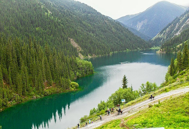
Kolsay Lake in Kazakhastan

Kolsay Lake in Kazakhastan


Most of Kazakhstan lies within a basin, meaning that rivers flow from surrounding highland areas, including the Tian Shan Mountains along the southern portion of the country, and end at a series of numerous lakes within the Kazakh lowlands.

Although not all of its lakes are formed in this way, many of its lakes are - its largest lakes include Lake Balkhash, with an area of 6,300 square miles (16,400 km2), and the north-eastern portion of the Caspian Sea, which is recognized as the world’s largest lake.

  • There are 48,262 “lakes” located in Kazakhstan, however, only 12,400 are large enough to be considered an actual lake

  • 296 lakes are larger than 10 sq km

  • 21 are larger than 100 sq km

  • Kazakhstan is also the 9th largest county in the world

Map of Kazakhstan (Image Source: SMIRNOVA et al.)

Map of Kazakhstan (Image Source: SMIRNOVA et al.)


8)     Argentina – 13,600

Nahuel Huapi Lake in the Patagonia of Argentina

Nahuel Huapi Lake in the Patagonia of Argentina


Argentina consists mainly of two different landscapes – the Andes Mountains along the western side, and the vast fertile lowlands that cover the northern and eastern parts of the country.

Due to both areas being glaciated during the last Ice Age, each place contains a high number of lakes, with the fertile Pampas region being peppered with many small lakes, such as Lake Gómez near the city of Junín.

Within the Andes Mountains is Argentina’s Lake District, an area featuring many finger-shaped lakes that were formed by previously-existing glaciers.

  • Northern Patagonia is home to the Lake District. A region that comprises of both southern Chile and Argentina and it’s known as the Switzerland of Patagonia.

    • The 1,522 foot (464m) deep Nahuel Huapi Lake is 1 of 19 major lakes in this region, and is also the largest

Lago Hermoso in the Northern Patagonia Lake’s District

Lago Hermoso in the Northern Patagonia Lake’s District


7)     Norway – 20,000

Lake Ringedalsvatnet in Norway

Lake Ringedalsvatnet in Norway


A country that was covered by glacial ice during the last Ice Age, Norway contains many lakes that were formed as the result of glacial processes.

Many man-made reservoir lakes were also created, made possible in large part by the existence of large and deep valleys along the western side of the country, formed by the large mountain range that makes up the backbone of the country.

Lakes include Tyrifjorden, a large 967 foot (295 m) deep lake around 25 miles (40 km) to the north-west of Oslo, Norway’s capital.

Norway (Image Source: Wikimedia Commons)

Norway (Image Source: Wikimedia Commons)


 6)     Brazil – 20,900

Lagoa da Conceição in Brazil

Lagoa da Conceição in Brazil


In part due to its vast land area, Brazil contains many lakes. Although many of these are located within the Amazon region, particularly where the large rivers have formed ox-bow lakes, many more are found outside of it.

For example, the country’s largest lake – Lagos dos Patos – exists in the extreme south-east of the country.

  • This large lagoon lake measures 180 miles (290 km) long and up to 40 miles (64 km) wide; it is separated from the Atlantic Ocean by a wide sandbar.

Brazil also contains many man-made lakes, such as the large Sobradinho Reservoir, which is over 6 times larger than Lake Mead, the largest man-made lake in the USA.


5)     Sweden – 22,600

The Northern Lights on Lake Torneträsk in Abisko National Park, Sweden

The Northern Lights on Lake Torneträsk in Abisko National Park, Sweden


Despite its relatively small size compared to the top four countries on this list, it is thanks to Sweden being covered in ice during the last Ice Age that it has such a high number of lakes.

Although many of these are small lakes that are dotted throughout the landscape, some are incredibly large in size. The largest of its lakes – Lake Vänern – is around 90 miles (145 km) long and up to 330 feet (100 m) deep in some parts.

  • There are 395 lakes with a surface area exceeding 10 sq km (4 sq miles) in Sweden

  • Lake Vänern is the largest lake in Sweden and the largest lake in the European Union (EU)

Lake Vänern (Image Source: Flickr)

Lake Vänern (Image Source: Flickr)


4)     China – 23,800

Tianchi Lake or Heaven Lake is the deepest lake and the largest crater lake in China

Tianchi Lake or Heaven Lake is the deepest lake and the largest crater lake in China


A country with a massive surface area, China also contains its fair share of lakes. Although many of these are freshwater, such as the Hongze and Nansi lakes which can be found across the East China Plain, some of its lakes are infact saline.

For example, the country’s largest lake – Qinghai Lake – is saline, and contains no water outflow channel. Although many lakes are located in the rainfall-heavy south and east of the country, a large portion of its lakes are also found on the Tibetan Plateau, as well as in mountainous areas across the western half of the country.

Poyang Lake bridge in China

Poyang Lake bridge in China


3)     USA – 102,500

Lake Powell in the United States of America

Lake Powell in the United States of America


A country which is known internationally for its vast Great Lakes along its northern border, the United States contains a huge number of lakes, many of which were formed by glacial processes during the last Ice Age.

Although many of its lakes are found either across the northern portion of the country, or in the northern valleys of the Rocky Mountains, lakes are frequently found in all regions of the country away from the deserts of the south-west.

The country also contains many man-made lakes, such as Lake Mead – the largest reservoir in the United States, which was created by the construction of the Hoover Dam in the 1930s.


  2)     Russia – 201,200

Lake Baikal in Russia

Lake Baikal in Russia


The world’s largest country in terms of land surface area, Russia contains over 200,000 lakes.

As most of the country is located at a rather high latitude, during the last Ice Age, ice covered the north and west of Russia. Although various factors prevented much ice accumulation across parts of Siberia, the previously ice-covered regions are today peppered with many lakes.

Although many glacially-formed lakes are found across northern Russia, the country’s largest lake – Lake Baikal – is not formed by glacial activity at all, but by plate tectonics. Two tectonic plates pull apart at this region, forming a Rift Valley that fills with water.

  • Lake Baikal: This 12,000 square mile (31,000 km2) lake is also widely considered to be the deepest lake in the world, with a maximum depth of 5,387 feet (1,642 m) and is about half the surface area of Lake Michigan (1 of 5 Great Lakes).


1)     Canada – 879,800

Being the second largest country in the world, it is no surprise that the country with the highest number of lakes is Canada – after all, a larger land volume means that there is a larger land area to include features such as lakes.

Sunrise in Lake Superior (Both USA and Canada)

Sunrise in Lake Superior (Both USA and Canada)


However, the largest country in the world – Russia – contains less than a quarter of the number of lakes than Canada does. The reason is due to the fact that the vast majority of Canada was situated under a large ice sheet during the last Ice Age – both glacial erosion and the vast weight of the ice sheet itself sculpted the landscape, leaving behind natural indentations when they retreated – these have since filled with water.

Although the largest lakes are Lake Superior and Huron (a large of which are also within the USA), many of these lakes are rather small, and can be found all over Canada.

Lake Louise in Canada

Lake Louise in Canada


  • 62% of the world’s lakes are in Canada (more than the rest of the world combined)

  • 9% of Canada’s surface area is covered by lakes

  • Lake Manitoba in the Canadian province of Manitoba is the Western Hemisphere’s largest salt lake and is 79 sq mi (205 sq km) larger than the Great Salt Lake of Utah

  • The Great Bear Lake is the largest lake in Canada that is located entirely in Canada and is about half the surface area of Lake Michigan


What About Finland?

According to Wikipedia:

“There are 187,888 lakes in Finland larger than 5 ares (500 square metres / 5,382 sq.ft.) Most are small, but there are 309 lakes or reservoirs larger than 10 km²”

However, keep in mind that 500 square meters is .12 acres. For comparison, the average soccer field is 1.86 acres.

The data that was sourced for this article defined a lake with a minimum area of 25 acres, which is over 200 times larger than the minimum size lake in Finland.

1 of 187,888 “lakes” in Finland (Image Source: Wikimedia)


The World Atlas notes:

“Finland's 187,888 lakes include all water bodies larger than 500 sq. m or just a little larger than the size of a basketball court. However, the list in the study was prepared by taking into account only lakes that are over 0.1 sq. km or 100,000 sq. m in size which is the size of about 18.5 football fields. Hence, Finland failed to feature on this list.”


 More Articles from Pedal Chile


References and Sources for “Countries with Most Lakes:”

  1. Busker, Tim, et al. “A Global Lake and Reservoir Volume Analysis Using a Surface Water Dataset and Satellite Altimetry.” Hydrology and Earth System Sciences, vol. 23, no. 2, 6 Feb. 2019, pp. 669–690, 10.5194/hess-23-669-2019.

  2. Messager, M., Lehner, B., Grill, G. et al. Estimating the volume and age of water stored in global lakes using a geo-statistical approach. Nat Commun 7, 13603 (2016). https://doi.org/10.1038/ncomms13603

  3. Timms, Brian V. “Salt Lakes in Australia: Present Problems and Prognosis for the Future.” Hydrobiologia, vol. 552, no. 1, Dec. 2005, pp. 1–15, 10.1007/s10750-005-1501-x.

  4. Maberly, Stephen C., et al. “Global Lake Thermal Regions Shift under Climate Change.” Nature Communications, vol. 11, no. 1, 6 Mar. 2020, 10.1038/s41467-020-15108-z.

  5. McDonald, Cory P., et al. “The Regional Abundance and Size Distribution of Lakes and Reservoirs in the United States and Implications for Estimates of Global Lake Extent.” Limnology and Oceanography, vol. 57, no. 2, Mar. 2012, pp. 597–606, 10.4319/lo.2012.57.2.0597.

  6. SMIRNOVA, DINA, et al. “The Trichoptera of Kazakhstan: A Review.” Zoosymposia, vol. 10, no. 1, 9 Aug. 2016, pp. 398–408, 10.11646/zoosymposia.10.1.36.

  7. Verpoorter, Charles, et al. “A Global Inventory of Lakes Based on High-Resolution Satellite Imagery.” Geophysical Research Letters, vol. 41, no. 18, 16 Sept. 2014, pp. 6396–6402, 10.1002/2014gl060641.

  8. “Which Country Has the Most Lakes in the World?” WorldAtlas, www.worldatlas.com.

Why Are Fire Trucks Red

red fire truck.jpg
 

When a great fire-engine is seen plunging along the street every one stops to look.
— From the 1907 book: Fire Fighters and Their Pets


Making up an incredibly important part of the emergency services, fire trucks perform an extremely vital function in maintaining public safety. They are instantly recognizable across the world, not only due to their loud sirens and flashing warning lights when attending an emergency, but also because of their distinctively garish red color.

But why are fire trucks red in the first place? Why are they not a bright orange, a yellow or even a blue color?

There are a few theories as to why they are decorated in this distinctive color.  

As always when tracing the origin and meaning of any word, phrase, tradition, or even a standard, there are several competing theories that offer an explanation as to why anything is named, or done in, the way that it is.

In this case, a few theories attempt to explain why fire trucks are almost always painted in a distinctively red color – although some are more believable than others.

Theory #1: Red & The cheapest color of paint

One theory is as follows: when the earliest fire departments were set up by unpaid volunteers, they had limited money to spend on equipment, including the paint of the fire engines. They found that red was the cheapest color to use, and so they chose that specific color to decorate its trucks.

However, this theory is unlikely true due to one reason – that red paint is often the most expensive color to produce, mainly due to the combination of pigments that are used. Therefore, other theories and ideas must be considered.

small fire truck.jpg

Theory #2: Red & The Most Expensive Color

Another theory therefore rests on red being the most expensive color. During the 19th Century, when fire departments and brigades were being devised across the United States, there was a huge amount of competition between neighboring towns and villages as to which fire department had the trucks that stood out the most. This included using the most expensive decoration, which involved utilizing a large amount of brass, and the most expensive paint color.

Therefore, decorating a fire truck in red paint would show the neighboring areas which town took the most pride in its fire department, and eventually, all fire departments used the same color.

Theory #3: Red Fire Trucks & Visibility

However, a third theory rests on one key component – visibility.

  • Due to its rather garish and stark hue, the color red stands out amongst a sea of rather neutral colors.

Although the second theory may have some weight to it, the first known red-painted fire engine dates back to 1721, many years before fire departments were devised on a wide scale.

Developed by an English inventor named Richard Newsham, this was a horse-drawn engine that could spray 100 US gallons (380 L) of water a minute. It is unknown as to why Richard Newsham chose red as the color, but it was most likely due to the starkness of the color. Some may even argue that he connected the incredible heat and the color of the red-orange flames with the color red.

Early Fire Trucks Were Small

A 1920 Model T Fire Truck (Image Source: Wikimedia Commons)

A 1920 Model T Fire Truck (Image Source: Wikimedia Commons)


Beginning in the early 1900s, the color red became associated with danger and fire trucks. Cars were black, and fire trucks were not much bigger than other vehicles on the road, so the difference in color was extremely important. During this time, sirens were low-powered and had to be cranked by hand and emergency lights were incredibly dim. The color red was the only thing that could be done to differentiate fire trucks from cars.

Most Likely Theory??: Red = Visibility

Out of all of the three theories, the visibility idea appears to be the most likely. This is further supported by another factor – that when automobiles first rode the streets in the early 20th Century, the only color of car available at that time was a cheap black hue, in order to keep the prices of automobiles as low as possible.


Any customer can have a car painted any color that he wants so long as it is black
— Henry Ford
1909 Ford Model T (Image Source: Wikimedia Commons)

1909 Ford Model T (Image Source: Wikimedia Commons)


A red fire truck would have stood out like a sore thumb against much of the rest of the traffic, ensuring that people would see a fast-moving fire engine coming from afar.

Modern Day Color of Fire Trucks

However, this does not answer why fire trucks are still painted red today. After all, the advent of warning systems such as bright, flashy and loud sirens mean that the color of the trucks is not as relevant today as it was many decades ago. Some studies have even suggested that using lime-yellow or white colors may, in fact, be safer in terms of reducing fire truck-related accidents.

A 2009 study by the United States Fire Administration (USFA) concluded that fluorescent colors, including yellow-green and orange, are easier to see in daylight than reddish hues.

Brightly Colored Fire Trucks

As a result of such studies a handful of fire departments around the world have switched to other brighter colors, including the Canberra Fire Brigade in Australia, which today uses a fluorescent yellow-green color for its fleet.


Yellow-Green Fire Truck in Australia (Image Source: Wikimedia Commons)

Yellow-Green Fire Truck in Australia (Image Source: Wikimedia Commons)


Red Trucks & Color Blind

Humans detect colors by using 3 types of photoreceptor cells in the retina, commonly known as cones. Color blindness results when one or more of these cones malfunctions.

  • Red-green color blindness (protanopia) is the most common, whereby a person has a challenging time distinguishing between red and green tints of colors

  • 1/12 men are on the color blindness spectrum

  • 1/250 females also experience varying levels of color blindness


Colors Perceived & CVD

Colors perceived by individuals having different types of Color vision deficiency (CVD)(Image Source: Badawy et al.)

Colors perceived by individuals having different types of Color vision deficiency (CVD)

(Image Source: Badawy et al.)


A recent 2018 study, researched colors of fire engines and the number of accidents by color of Fire Truck:

  • Red
  • Lime-Green
  • Lime-Yellow
  • Yellow

So, what were the results after 4 years and more than 2.6 million fire truck runs??

  • Red fire trucks had nearly double the accident rate of the brighter lime/green, lime/yellow, and yellow fire engines.

Today, many Fire Departments use a lime-yellow colored fire truck

Today, many Fire Departments use a lime-yellow colored fire truck


The color red for fire trucks made sense when all the other cars on the street where black. However, today, their are much safer colors that can be used since red is one of the least visible colors, even before we get into the whole colorblindness issues.

Tradition & Red Fire Engines

However, the majority of fire departments have kept their red color, for the main reason that red is the traditional color that has become synonymous with fire trucks. While the aforementioned USFA study concluded that fluorescent yellow-green colors may increase vehicle visibility, the report also concluded that being able to recognize the vehicle instantly – which is based on the common knowledge that fire trucks are red – is also incredibly important with regards to safety.

Therefore, continuing to paint fire trucks in a red color may, after all, be the most sensible thing to do. 

Fire Trucks in Chile

In Chile, all 40,000+ firefighters (bomberos) are volunteers and actually pay monthly contributions for their service. Fire trucks come in many different colors in Chile, South America, with Fire Truck Red being the most common color.

Red Fire Truck in Chile, South America (Image Source)

Red Fire Truck in Chile, South America (Image Source)


valentina - bio pic copy.jpg

Valentina is a guide for Pedal Chile and is our geology expert. Valentina has been in love with geology ever since she first saw Villarrica glowing in her native country of Chile. Valentina was born and raised in La Patagonia, which probably explains her affinity for adventuring. When Valentina isn’t crushing some poor dude’s soul, you can find her shredding down Rucapillán. Favorite season: Austral Summer


References and Sources for “Why Are Fire Trucks Red”

  1. Badawy, Abdel-Rahman, et al. “Contact Lenses for Color Blindness.” Advanced Healthcare Materials, vol. 7, no. 12, 26 Apr. 2018, p. 1800152, 10.1002/adhm.201800152.

  2. Contributors to Wikimedia projects. “Multi-Volume Reference Work.” Wikisource.org, Wikimedia Foundation, Inc., 16 June 2008, en.wikisource.org/wiki/Dictionary_of_National_Biography.

  3. Hitch, Georgia. “Why Are Canberra’s Fire Engines Yellow instead of Red like Other States?” Www.abc.net.au, 4 Sept. 2016.

  4. Kahl, J.T., Anderson, N.J., Casner, G. et al. Firefighter daytime visibility: trim properties and conspicuity. Fash Text 6, 18 (2019). https://doi.org/10.1186/s40691-019-0173-5

  5. Nichols, Sam. “No Seriously, Why Are Fire Trucks Red?” Www.vice.com, 9 Jan. 2018, www.vice.com/en/article/ne44az/no-seriously-why-are-fire-trucks-red.

  6. Solomon, Stephen S., and James G. King. “Fire Truck Visibility: Red May Not Be the Most Visible Color, Considering the Rate of Accident Involvement with Fire Trucks.” Ergonomics in Design: The Quarterly of Human Factors Applications, vol. 5, no. 2, Apr. 1997, pp. 4–10, 10.1177/106480469700500202.

  7. “Why Are Fire Trucks Red?” Www.rocklandfirefighters.org, 19 Jan. 2007.

  8. “Why Lime-Yellow Fire Trucks Are Safer than Red.” Https://Www.apa.org, 2014, www.apa.org/action/resources/research-in-action/lime.

Hottest Countries in the World - Top 10

6 of the top 10 hottest countries are located in Africa and near or in the Sahara Desert (Image Source: Wikimedia Commons)

6 of the top 10 hottest countries are located in Africa and near or in the Sahara Desert (Image Source: Wikimedia Commons)


Although all of the Earth’s countries located away from the equatorial regions experience seasons, some with winters and summers that are more extreme than others. There are plenty of areas on Earth that spend the whole year in incredibly hot temperatures, as these 10 countries are the hottest on Earth.

  • Calculated by averaging their maximum and minimum daily temperatures, recorded between 1961 and 1990

  • All of these are either located on the African continent, or are island nations in the Indian and Pacific Oceans.


10)   Benin – 81.59°F (27.55°C)

Image Source: Wikimedia Commons


Located in western Africa, Benin is bordered by Nigeria on the east and Togo on the west.

The majority of its population lives on its southern side, which borders the Bight of Benin, part of the northernmost tropical part of the Atlantic Ocean. The country’s interior is mainly made up of a savannah-type environment.

  • Highest recorded temperature in Benin = 113°F (45°C)

  • Average yearly daytime temperature: 91.4°F (33°C)

Atakora - a village in Benin (Image Source: Wikimedia Commons)


9)   Palau – 81.68°F (27.60°C)

Image Source: Wikimedia Commons


Palau is an island nation that is situated in the western Pacific Ocean, with the islands of the Philippines to the east, and Indonesia to the south. Located between 2.8°and 8° north of the Equator, this is a great example of a tropical island that experiences a guaranteed warm and humid climate all year round.

However, another factor comes into play in terms of maintaining the heat – the warm temperature of the surrounding Pacific Ocean ensures that temperatures do not drop quickly at night after spending a day being heated by the overhead Sun.

  • Hottest recorded temperature = 95°F (35°C)

  • Average yearly daytime temperature: 87°F (31°C)

    • At night, the average temperature does not drop by more than 10°F (5.5 °C)

  • Annual average dew point temperature: 76°F (24.4°C) which is over 13% more humid than the most humid city in the United States (Key West, FL)

Palau archipelago (Image Source: Wikimedia Commons)


8)   Maldives – 81.77°F (27.65°C)

Image Source: Wikimedia Commons


Located in the Indian Ocean to the south-west of India and Sri Lanka, the Maldives are a chain of small islands that are around 541 miles (870 km) in length. With its capital Malé, situated at around 4.2° north of the Equator, it is not surprising that these islands experience incredibly warm and humid weather on a constant basis.

  • The Republic of Maldives are 300 miles south-west of India

  • Maximum elevation of the entire island chain = 2 meters

  • Highest recorded temperature = 99°F (37°C)

  • Average yearly daytime temperature: 86°F (30°C)

The Maldives archipelago consists of 1192 islands, most of which are so tiny you can spot the ocean from any spot.

The Maldives archipelago consists of 1192 islands, most of which are so tiny you can spot the ocean from any spot.


7)   Mauritania - 81.77°F (27.65°C)

Image Source: Wikimedia Commons


Located in north-western Africa, it is understandable that Mauritania has such a high average temperature – much of it lies within the Sahara Desert, with the semi-arid Sahel region across the south of the country.

Bordered by Senegal to the south, Mali to the south and east, and the countries of Algeria and Western Sahara to the north, the western side of the country is most likely to be the coolest area, since it borders directly onto the Atlantic Ocean.

  • Yearly daily temperature ranges from 55°F to 104°F (13°C to 40°C)

  • Hottest recorded temperature in Mauritania = 119°F (48°C)

  • Average daytime temperature exceeds 100°F (38°C) over half the year

Terjît valley in Mauritania

Terjît valley in Mauritania


6)   Senegal – 82.13°F (27.85°C)

Image Source: Wikimedia Commons


With its northern section within the Sahel region, and a savannah landscape typifying much of the central and southern parts of the country, Senegal is placed at number six on this list.

Located in western Africa to the south of Mauritania, west of Mail and the north of Guinea, Senegal is in a prime position to receive hot weather.

Its close position to the Equator ensures that the country receives a hot climate on a constant basis. 

  • Hottest recorded temperature in Senegal = 123°F (50.5 °C)

  • Average yearly daytime temperature exceeds 93°F (34°C) for the interior of the country

Saloum Delta National Park, Senegal

Saloum Delta National Park, Senegal


5)   Tuvalu – 82.40°F (28.00°C)

Image Source: Wikimedia Commons


Tuvalu is a country that is made up of 9 separate coral islands in the south-western Pacific Ocean, located around halfway between Australia and Hawaii.

Being surrounded by warm tropical waters, and situated at a latitude between -10° and -5° North, the conditions are perfect to allow for hot days and warm, humid nights, regardless of the time of year.

  • 4th smallest nation in the world

  • Maximum elevation is 5 meters

  • Average temperature lies between 77ºF to 88°F (25ºC to 31ºC)

  • Rainfall varies from 2,700 mm per year in the northern islands to 3,500 mm in the southern

  • Highest recorded temperature in Tuvalu = 106°F (41°C)

  • Lowest recorded temperature = 68°F (20°C)

  • Yearly average dew-point of Funafuti (capital city): 77°F (25°F) or 3% more humid than Bangkok, Thailand.

Tuvalu Funafuti Atoll (Image Source: Wikimedia Commons)


 4)   Djibouti – 82.40°F (28.00°C)

Image Source: Wikimedia Commons

Situated on the northern side of the Horn of Africa, Djibouti is an incredibly arid country that consists of almost entirely desert areas.

  • Bordered by Somalia, Ethiopia and Eritrea, the country is located on the western end of the Gulf of Aden, which links to the Red Sea via the Bab al-Mandab Strait.

  • Due to being around 12° to the north of the Equator, Djibouti endures incredibly hot weather.

During the hot months, May to September, the temperature ranges from 97°F to 117 °F (36°C to 47 °C)

  • Highest recorded temperature in Djibouti = 115°F (46°C)

  • Lowest recorded temperature = 61°F (16°C)

Djibouti City, Djibouti

  • Summer daytime temperatures hover around 104°F (40°C), while at night, they drop to 86°F (30°C) in the country's capital

Lake Abha in Djibouti. This is a salt lake.

Lake Abha in Djibouti. This is a salt lake.


3)   Kiribati – 82.76°F (28.20°C)

Image Source: Wikimedia Commons

The climate of Kiribati is hot and humid, with very little variation in maximum and minimum temperatures throughout the year.
— International Journal of Environmental Research and Public Health


An island nation in the central Pacific Ocean, Kiribati consists of 9 different islands that straddle the Equator line. With the Sun almost directly overhead the entire year, and the warm and tropical Pacific waters surrounding the islands, the ingredients are perfect in allowing for year-round heat and humidity. 

Christmas Island and lagoon in Kiribati

Christmas Island and lagoon in Kiribati

  • The average elevation is less than 3 meters above sea level

  • Highest recorded temperature = 113°F (45°C)

  • The average yearly daytime temperature: 88°F (31°C)

  • Tarawa, the capital city of Kiribati is one of the most humid cities in the world and has an annual average dew point temperature of 75.4°F | 24.1°C which is even muggier than Bangkok, Thailand yearly average of 74°F | 23.3°C


 2)   Mali – 82.85°F (28.25°C)

Image Source: Wikimedia Commons

Mali (Image Source: The World Factbook)

Mali, the second hottest nation in the world, is a landlocked country in western Africa, bordered by several countries including Mauritania, Senegal and Burkina Faso, which are also on this list.

Although the south-east of the country has a savanna-like landscape, much of the south lies within the Sahel region. However, the large northern extent of Mali lies within the Sahara Desert, with scorching hot days occurring for most of the year, peaking far above 110°F (43°C) between the months of June and September.

Combined with the hot and humid conditions of the savanna along the south of Mali, as well as the lack of fresh sea breezes, results in a country that suffers through incredibly stifling temperatures.

  • Mali is twice the size of the state of Texas (USA) and mostly lies in the Sahara Desert.

  • Highest recorded temperature = 130°F (54°C)

  • Average yearly daytime temperature: 88°F (31°C)

  • The average daytime temperature ranges from low 80s to low 100s°F (28 to 40°C)

Village Telly in Mali (Image Source: Wikimedia Commons)


1)     Burkina Faso – 82.92°F (28.29°C)

Image Source: Wikimedia Commons

  • The country with the highest average temperature on Earth, Burkina Faso, is a landlocked country in western Africa that borders the second hottest country of Mali.


Image Source: The World Factbook

In terms of its landscape, it can be loosely divided into two halves – with the south of the country being characterised by a savanna landscape, and the northern half consisting of the semi-arid Sahel region, Burkina Faso contains plenty of dryland environments.

  • The lack of a coastline close to the country also prevents any relatively cooler air from reaching the country from the Atlantic Ocean, which is located around 300 miles (480 km) to the south.  

  • Highest recorded temperature = 117 °F (47°C)

Burkina Faso: 3 Climate Zones

  1. Hot tropical savanna with a short rainy season (southern half)

  2. Tropical hot semi-arid steppe climate (central and northern)

  3. Small, hot desert in the north that borders the Sahara Desert

Village in Burkina Faso - The hottest country on the Earth

Village in Burkina Faso - The hottest country on the Earth


Bottom Line

Burkina Faso, a landlocked Sahelian country, is the hottest country in the world - with an average daily temperature of 83°F (29°C).

  • Located in the Sahara Desert, this western Africa nation gets blasted by heat, from the harmattan, a dry east wind that picks up a considerable amount of dust and heat from the Sahara.

  • Ouagadougou, the capital of Burkina Faso, averages over 100°F (38°C) from March to May in the hot season. During the “cool” season, the temperature drops to an average of 90°F (32°C).

    • For comparison, this is nearly 20% warmer than Bangkok, Thailand.


valentina - bio pic copy.jpg

Valentina is a guide for Pedal Chile and is our geology expert. Valentina has been in love with geology ever since she first saw Villarrica glowing in her native country of Chile. Valentina was born and raised in La Patagonia, which probably explains her affinity for adventuring. When Valentina isn’t crushing some poor dude’s soul, you can find her shredding down Rucapillán. Favorite season: Austral Summer 


More articles from Pedal Chile


References and sources for hottest countries:

  1. “Climate and Temperature Development.” Worlddata.info. www.worlddata.info

  2. Fall, Souleymane, et al. “Analysis of Mean Climate Conditions in Senegal (1971–98).” Earth Interactions, vol. 10, no. 5, 1 Jan. 2006, pp. 1–40, 10.1175/ei158.1.

  3. “Harmattan.” Wikipedia, 8 Jan. 2021, en.wikipedia.org/wiki/Harmattan. Accessed 6 Feb. 2021.

  4. “Hottest Countries in the World 2021.” Worldpopulationreview.com, worldpopulationreview.com/country-rankings/hottest-countries-in-the-world.

  5. Idriss, Abdoulkader Ibrahim & Ahmed, Ramadan & Kassim, Rima & Idris, Abdou & Barutcu, Burak & Awalo, Abdoulhamid & AKINCI, T. Cetin. (2019). Suitability and evaluating wind speed probability distribution models in a hot climate: Djibouti case study. International Journal of Renewable Energy Research. 9. 1-11.

  6. Madaleno, I.M. (2011). Climate change in the Pacific: Tuvalu case-study. WIT Transactions on Ecology and the Environment. 144. 243-252. 10.2495/ECO110221.

  7. McIver, Lachlan; Woodward, Alistair; Davies, Seren; Tibwe, Tebikau; Iddings, Steven. 2014. "Assessment of the Health Impacts of Climate Change in Kiribati" Int. J. Environ. Res. Public Health 11, no. 5: 5224-5240. https://doi.org/10.3390/ijerph110505224

  8. Naia, Marisa & Brito, José. (2021). Geographical Atlas of Mauritania.

  9. “This Month in Climate History: Earth’s Hottest Temperature | National Centers for Environmental Information (NCEI) Formerly Known as National Climatic Data Center (NCDC).” Noaa.gov, 2012, www.ncdc.noaa.gov/news/month-climate-history-earth%E2%80%99s-hottest-temperature.

  10. “Where Is the Hottest Place on Earth?” Earthobservatory.nasa.gov, 5 Apr. 2012, earthobservatory.nasa.gov/features/HottestSpot.

The Driest Desert in the World

El Valle de la Luna or Valley of the Moon in the Atacama Desert, Chile - South America.

El Valle de la Luna or Valley of the Moon in the Atacama Desert, Chile - South America.


What is a desert?

Defined as a large expanse of land that is extremely dry, and consists of either no vegetation, or limited areas that are vegetated, deserts make up a significant part of the Earth’s landscape.

Over one-third of the Earth's land surface is desert and at least one desert is found on all of the continents, including the Tabernas Desert in Europe.


Valle de la Luna in San Pedro de Atacama, Chile


Reasons for Deserts

They are caused by a number of factors, which include permanent areas of high air pressure preventing rain from developing over an area, rain shadow effects, and even because an area of land is too far away from large water bodies to receive rain.

The variety of different factors also means that some deserts are drier than others, ranging from semi-arid expanses of land through to hyper-arid areas, some of which have not seen measurable rain for hundreds of years.

Also, although many deserts around the world are located in hot and dry locations, and often consist of sand or rocks, some also exist in cold polar regions.


The Atacama: The Driest Warm Desert on Earth

 
The Atacama Desert is one of the most extreme environments on Earth. As the driest hot desert in the world, life here is extremely marginal.
— Quaternary Science Reviews


The Atacama desert in Chile, South America


If we are looking at the driest warm desert in the world – one which is rocky, sunny and receives hot days all year round, then the driest one is the Atacama Desert.

(Image Source: Clarke 2006)

(Image Source: Clarke 2006)

Making up the central section of the west coast of South America, the Atacama runs from the plateau of the Andes Mountains, and borders the Pacific Ocean on its western side. With a total area of 40,541 square miles (105,000 km2), it occupies the northern quarter of Chile, and small parts of Argentina, Bolivia and Peru. It contains a spectacular landscape of rocky plains, barren hills and the large mountains of the Andes on its eastern side.

Vast salt flats cover parts of the desert, the largest of these being Salar de Uyuni in the Bolivian section of the Atacama. Natural saltwater pools accumulate within some of the salt flats, often from groundwater that has risen to the surface.

Excluding polar regions, the Atacama is the driest desert in the world. Although the average rainfall across the whole desert is around 0.6 inches (15 mm) per year, some places within the Atacama barely record 0.1 inches (2.5 mm) of rainfall a year.

The small city of Calama, located in the heart of the desert, is one of the driest cities in the world, with an average annual precipitation of only 0.2 inches (5 mm). In 2015, parts of the hyper-arid core received unexpected rainfall; this is estimated to have been the first rain to land on those areas for at least 500 years.

Near the Chilean city of Calama (Image Source: Flickr)


The Atacama's extreme aridity is caused by three main factors:

  1. Rain shadow

  2. Prevailing high air pressure

  3. Cold Pacific Ocean current

1) Rain Shadow

Firstly, being located to the west of the Andes Mountains means that, when the prevailing south-easterly trade winds bring in moisture across the South American continent from the South Atlantic, they reach the Andes and rise. This results in the moisture condensing and falling on the eastern side of the Andes – very little of it reaches the Atacama side.

2) Prevailing High-air Pressure

Secondly, constant high air pressure over the region prevents moisture from falling over the region, and means that any moisture is converted into water vapor, and so cannot condense into rain.

atacama desert pic.jpg

3) Cold Pacific Ocean Current

However, the last factor is due to the cold Humboldt Current – running northwards along much of South America’s western coast, the current brings cold water up from the southern Pacific region, fairly close to Antarctica. This means that any onshore wind is chilled, and so it cannot pick up any moisture from the Pacific.

These three factors merge to create a perfectly dry storm – an incredibly arid region of South America.

The Atacama Desert

The Atacama Desert


 The McMurdo Dry Valleys, Antartica: Driest Place on Earth

Wright Valley in the McMurdo Dry Valleys, Antarctica - (Image Source: Wikimedia Commons)


The McMurdo Dry Valleys of Antarctica are an extreme environment. They comprise a large (4,000 km2) ice-free area considered to be the driest and coldest desert on Earth, limiting to the survival of many forms of life
— Polar Biology


Although the Atacama is the driest warm desert on Earth that fits the definition of a warm, rocky and sunny desert, there is one place on Earth which is even drier – The McMurdo Dry Valleys in Antarctica, the driest place on Earth.

  • Located around 2,000 miles (3,400 km) to the south of New Zealand, these valleys consist of a 1,850 square mile (4,800 km2) area that is completely barren of any ice or snow.

  • Cold air holds less water vapor than warm air

    • Air at freezing temperature (32°F) holds 10 times less moisture than air at 100°F

    • Air at 32°F holds about 20 times less moisture than air at 130°F

    • Average temperature of the Mcmurdo Dry Valleys = -16°F/-27°C

  • The McMurdo Dry Valleys have not seen rain for nearly 2 million years

Bull Pass in McMurdo Dry Valleys (Image Source: Wikimedia Commons)

Bull Pass in McMurdo Dry Valleys (Image Source: Wikimedia Commons)

Katabatic Winds: Antarctica

This is due to the presence of mountains to the south and west of the valleys, which cause katabatic winds to form.

This means that cold air is dragged down from the ice-covered region that overlooks the valleys, and in turn warms up. These strong katabatic winds cause any ice or snow that has slid or drifted into the dry valleys region to evaporate.


Katabatic Winds (Image Source: Wikimedia Commons)

What are Katabatic Winds?

  • Katabatic Winds = winds that blow down slopes that are cooled by radiation

    • Strong winds that are a climatic feature of Antarctica

    • Winds caused by cold denser air falling down the slope of the Antarctic continent

    • Katabatic Winds average 45-mph (72kph)

      • Katabatic winds have been recorded approaching 150-mph (241-kph)

Katabatic wind is a gravity flow maintained by the temperature/density difference of the air in the surface layer when compared with the free air temperature at the same altitude further down the slope.


McMurdo Dry Valleys: Zero Rain

Very little precipitation falls in the region. No rain has fallen in the region for nearly two million years, and snow falls are very little, with an average of 4 inches (10cm) falling in the valleys per year.

Image Source: (Dreesens et al.)

A combination of the aforementioned katabatic winds, overlooking mountains and incredibly cold temperatures prevents more measurable amounts of snow from falling, and the strong and dry winds prevent any rare meltwater from sinking far into the soil.

Therefore, although the Atacama Desert is drier in terms of annual precipitation levels being lower, the McMurdo Dry Valleys have been completely barren of any rainfall for a far longer time.

The McMurdo Dry Valleys, with a combined area of approximately 4800 km2, is the largest ice-free area in Antarctica. This region was discovered by members of Robert Falcon Scott’s party during their 1903 expedition to reach the South Pole.


bottom line

The Atacama is the driest non-polar desert in the world while the McMurdo Dry Valleys is the coldest polar desert on planet Earth. Both places are thought to resemble Mars and are both used as training grounds for astronauts.


valentina - bio pic copy.jpg

Valentina is a guide for Pedal Chile and is our geology expert. Valentina has been in love with geology ever since she first saw Villarrica glowing in her native country of Chile. Valentina was born and raised in La Patagonia, which probably explains her affinity for adventuring. When Valentina isn’t crushing some poor dude’s soul, you can find her shredding down Rucapillán. Favorite season: Austral Summer


More articles from Pedal Chile


Sources and references

  1. Cain, Fraser. “What Is the Driest Place on Earth?” Universe Today, 12 June 2008, www.universetoday.com/15031/driest-place-on-earth/.

  2. California Academy of Sciences. “The Desert Biome.” Berkeley.edu, 2019, ucmp.berkeley.edu/exhibits/biomes/deserts.php.

  3. Charlotte L. King, Andrew R. Millard, Darren R. Gröcke, Vivien G. Standen, Bernardo T. Arriaza, Siân E. Halcrow. “Marine resource reliance in the human populations of the Atacama Desert, northern Chile – A view from prehistory.Quaternary Science Reviews, Volume 182,2018, P. 163-174.

  4. Clarke, Jonathan D.A. “Antiquity of Aridity in the Chilean Atacama Desert.” Geomorphology, vol. 73, no. 1-2, Jan. 2006, pp. 101–114, 10.1016/j.geomorph.2005.06.008.

  5. Crits-Christoph, A., Robinson, C.K., Barnum, T. et al. Colonization patterns of soil microbial communities in the Atacama Desert. Microbiome 1, 28 (2013). https://doi.org/10.1186/2049-2618-1-28

  6. Doran, Peter T. “Valley Floor Climate Observations from the McMurdo Dry Valleys, Antarctica, 1986–2000.” Journal of Geophysical Research, vol. 107, no. D24, 2002, 10.1029/2001jd002045.

  7. Dreesens, Lisa, et al. “The Distribution and Identity of Edaphic Fungi in the McMurdo Dry Valleys.” Biology, vol. 3, no. 3, 30 July 2014, pp. 466–483, 10.3390/biology3030466.

  8. Friedlander, Blaine. “For Arid, Mars-like Desert, Rain Brings Death.” Phys.org, 14 Nov. 2018, phys.org/news/2018-11-arid-mars-like-peruvian-death.html.

  9. Juli Hennings, Juli, and Harry Lynch. “Exploring Earth’s Driest Deserts | EarthDate.” Www.earthdate.org, 2017, www.earthdate.org/exploring-earths-driest-deserts.

  10. Nkem, Johnson N., et al. “Wind Dispersal of Soil Invertebrates in the McMurdo Dry Valleys, Antarctica.” Polar Biology, vol. 29, no. 4, 27 Sept. 2005, pp. 346–352, 10.1007/s00300-005-0061-x.

  11. November 2013, Becky Oskin 01. “Antarctic Hills Haven’t Seen Water in 14 Million Years.” Livescience.com, 1 Nov. 2013, www.livescience.com/40890-antarctic-dry-valleys-no-water.html.

  12. Nylen, Thomas H., et al. “Climatology of Katabatic Winds in the McMurdo Dry Valleys, Southern Victoria Land, Antarctica.” Journal of Geophysical Research: Atmospheres, vol. 109, no. D3, 14 Feb. 2004, p. n/a-n/a, 10.1029/2003jd003937.

  13. Parish, Thomas R., and John J. Cassano. “The Role of Katabatic Winds on the Antarctic Surface Wind Regime.” Monthly Weather Review, vol. 131, no. 2, Feb. 2003, pp. 317–333, 2.0.co;2">10.1175/1520-0493(2003)131<0317:trokwo>2.0.co;2.

  14. Speirs, Johanna C., et al. “Regional Climate Variability Driven by Foehn Winds in the McMurdo Dry Valleys, Antarctica.” International Journal of Climatology, vol. 33, no. 4, 4 Apr. 2012, pp. 945–958, 10.1002/joc.3481.

What is the largest river in the world

Aerial view of the Amazon  - - - (Image Source: Wikimedia Commons)

Aerial view of the Amazon - - - (Image Source: Wikimedia Commons)


Although lists of the longest rivers in the world are often easy to find, they do not tell the reader much about how much water is discharged by the rivers.

  • This list details the five rivers in the world with the largest average discharge that is recorded at the mouth.


5) Madeira River, South America – 1.1 million cubic feet (31,200 m3) per second

Image Source: Wikimedia Commons


Flowing through the southern Amazon Rainforest, the Madeira River is a major waterway that is fed by a large watershed of over 500,000 square miles (1.3 million km2) in area.

Fed by a myriad of rivers, the Madeira flows into the River Amazon around 150 km to the east of Manaus with an average discharge of 1.1 million cubic feet (31,200 m3) per second.

The large water volume of the Madeira River is due to a few reasons:

  • Firstly, the size of the watershed, which contains a myriad of rivers that feed into the Madeira, and the fact that its western side drains part of the Andes Mountains.

  • However, the most important reason is due to the excessive rainfall within the region – being a tropical environment, extremely high rainfall totals occur over the Amazon rainforest.

  • Within the Madeira basin, the mean annual precipitation is around 78 inches (2,000mm), which provides the river with a massive amount of water all year round.


The Madeira River is the largest tributary of the Amazon River, with the largest catchment area, water volume, and sediment flow among its tributaries.

Madeira River


4)   Orinoco River, South America – 1.31 million cubic feet (37,000 m3) per second

Image Source: (Yepez et al.)


The Orinoco River is the fourth most voluminous river in the world, with a discharge rate of 1.31 million cubic feet (37,000 m3) per second recorded at its mouth, where it flows into the Atlantic Ocean.

It has a vast watershed that covers four-fifths of Venezuela and a quarter of Colombia – the southern section of the watershed is located within the northern reaches of the Amazon Rainforest.

Image Source: (Mora et al.)

The intense tropical rainfall which falls in the Orinoco Basin is the main reason for such a high river water volume - although the dense rainforest reduces water runoff rates to some degree, much of it ends up draining into the River Orinoco.

The large watershed size also contributes to its high river volume – with a vast 366,000 square mile (948,000 km2) watershed, there is plenty of intense rainfall that can run off into the Orinoco.

Furthermore, although the southern parts of the watershed consist of dense rainforest, the northern side tends to be of a more savannah-like landscape – the lack of trees allows high runoff rates to occur during periods of high rainfall.

The Orinoco River, near Puerto Ayacucho airport, Venezuela (Image Source)


3)   Ganges River, Asia – 1.34 million cubic feet (38,100 m3) per second

Image Source: (Singh et al.)


Flowing from the Himalayan Mountains, the Ganges crosses northern India, and meets the Indian Ocean via the Ganges delta, which straddles both India and Bangladesh.

With a length of 1,560 miles (2,510 km)], despite the Ganges being relatively shorter than a number of the world’s most renowned rivers, it is the river with the third highest discharge in the world.

  • Its large watershed is the main reason for this – draining one fourth of India, there is a vast area of land over which rainfall runoff can run into the river. To the south, large areas of land are used for agricultural purposes – with a lack of trees, rainfall quickly runs off towards the river.

  • The Himalayan Mountains – which lie to the north of the Ganges – also contribute to its high discharge. Many rivers that flow southwards from the mountains reach the Ganges, which therefore accumulates runoff from both precipitation and glacier meltwater.

Ganges River


Although rainfall rates are seasonal along the watershed, the intense monsoon rainfall – which occurs between June and September, also increases the discharge massively, which peaks towards the end of this period. 


2)   Congo River, Africa – 1.45 million cubic feet (41,200 m3) per second

Image Source: Wikimedia Commons


The second highest river in the world by volume, the Congo flows for 2,900 miles (4,700 km) through a large section of western and central Africa – rising in north-eastern Zambia and discharging into the Atlantic Ocean.

Much of its course runs through the Democratic Republic of the Congo, and it has a vast watershed that includes the Congo Basin rainforest, and a large portion of the highlands of the East African Rift system.

The size and nature of the watershed is partly responsible for the high discharge – with an area of 1,335,000 miles2 (3,457,000 km2) being drained by one river, and an area that includes drainage from vast savannah and highland areas that are often not forested, it is little surprise that the volume of water flowing through the mouth of the Congo is so large.

Congo River. Kisangani, Democratic Republic of Congo (Image Source: Flickr)


In addition, incredibly high rainfall rates – related to the fact that the river is located almost wholly within a tropical climate zone – also amplify the Congo’s discharge. The Congo Basin receives an average of 60 inches (1,500 mm) of rainfall per year – a great amount of this drains into the Atlantic.


 1)     Amazon River, South America – 7.38 million cubic feet (209,000 m3) per second

Image Source: Wikimedia Commons


Although the Amazon is the second longest river in the world, it is also – by a considerable amount – the largest river in the world by water volume and has over 4 times the discharge of the Congo River, the world’s second largest river.

Aerial view of the Amazon Rainforest, near Manaus, the capital of the Brazilian state of Amazonas, Brazil. (Image Source: Flickr)


  • The Amazon empties 7 million cubic feet of water in the ocean every second, which is more than the volume of water discharged by the next six largest rivers combined

    • The daily discharge at the mouth of the Amazon averages 4 billion gallons of water each and everyday

  • 16 - 18% of the world’s runoff to the oceans is discharged from the Amazon River

  • Not a single bridge crosses the Amazon

  • The Mississippi River, the largest river in North America, has 10 times less water volume than the Amazon

  • 4 of the 10 largest rivers on Earth in terms of water discharge and drainage area are located in the Amazon River Basin


The Amazon River Basin - - - (Image Source: Montanher et al.)


The Amazon flows for 4,000 miles (6,400 km) across much of South America, rising in southern Peru, in the Andes Mountains, and traveling westwards through the Amazon Basin for most of its route, after which it drains into the Atlantic Ocean in the east.

  • With an incredibly large 2.7 million square miles (7 million km2) drainage basin, that covers much of the Amazon Rainforest, and drains other areas (such as parts of the Andes Mountains), this is a large reason that explains such a high discharge at the mouth of the river.

  • The tropical climate of the region also contributes massively to this – with much of the Amazon Rainforest receiving between around 60 and 120 inches (1,500 and 3,000 mm) of rainfall per year, there is a constant supply of runoff water which drains from the Amazon watershed – the only outlet channel for this is the mouth of the Amazon River.


valentina - bio pic copy.jpg

Valentina is a guide for Pedal Chile and is our resident badass. Valentina was born and raised in La Patagonia, which probably explains her affinity for adventuring. When Valentina isn’t crushing some poor dude’s soul, you can find her shredding down Rucapillán. Favorite season: Austral Summer


More articles from Pedal Chile

References and sources

  1. https://www.researchgate.net/publication/226326945_Assessment_of_environmental_changes_in_the_Orinoco_River_delta#pf2

  2. https://www.britannica.com/place/Orinoco-River

  3. https://www.britannica.com/place/Ganges-River

  4. https://www.britannica.com/place/Congo-River

  5. https://www.britannica.com/place/Amazon-River

  6. https://wwf.panda.org/discover/knowledge_hub/where_we_work/amazon/about_the_amazon/

  7. Montanher, Otávio Cristiano, et al. “Temporal Trend of the Suspended Sediment Transport of the Amazon River (1984–2016).” Hydrological Sciences Journal, vol. 63, no. 13-14, 26 Oct. 2018, pp. 1901–1912, 10.1080/02626667.2018.1546387.

  8. Mora, Abrahan, et al. “Hydrological Control, Fractionation, and Fluxes of Dissolved Rare Earth Elements in the Lower Orinoco River, Venezuela.” Applied Geochemistry, vol. 112, Jan. 2020, p. 104462, 10.1016/j.apgeochem.2019.104462.

  9. Moreira-Turcq, P., Seyler, P., Guyot, J. L. & Etcheber, H. Exportation of organic carbon from the Amazon River and its main tributaries. Hydrological Processes 17, 1329–1344, https://doi.org/10.1002/Hyp.1287 (2003)‌

  10. Singh, Munendra, et al. “Geogenic Distribution and Baseline Concentration of Heavy Metals in Sediments of the Ganges River, India.” Journal of Geochemical Exploration, vol. 80, no. 1, Aug. 2003, pp. 1–17, 10.1016/s0375-6742(03)00016-5.

  11. Yepez, Santiago, et al. “Retrieval of Suspended Sediment Concentrations Using Landsat-8 OLI Satellite Images in the Orinoco River (Venezuela).” Comptes Rendus Geoscience, vol. 350, no. 1-2, Jan. 2018, pp. 20–30, 10.1016/j.crte.2017.08.004.  

What Is The Widest Country In The World

world-political.jpg

Although you will often find lists of the world’s largest countries, this article details the world’s longest countries, based on measuring each one from the most easterly point to the most westerly. Several countries span a considerable distance around the globe, and sometimes have a significantly longer lateral distance than a north to south one.

In this list, I rank the widest countries in the world from east to west.

10)  Kazakhstan – 1,820 miles (2,929 km)

Image Source: Wikimedia Commons

Bordering China to its east, and Russia to its north and east, Kazakhstan spans a significant proportion of Central Asia.

Its landscape consists mainly of steppe plains, which occupy a large amount of its land area – however, deserts also dominate the south and south-west of the country, as does the large Caspian Sea.

  • 10)  Kazakhstan – 1,820 miles (2,929 km)


9)     India – 1,822 miles (2,932 km)

Image Source: Wikimedia Commons

From its easternmost point at Kibithu, and its most westerly point – Sir Creek, Gujarat State – the northern section of India has an east-to-west span of just over 1,800 miles.

The world’s second-largest country in terms of population, India is also one of the world’s largest. With large areas used for agriculture, the Himalayan Mountains to the north, and the Thar Desert making up the north-west of the county, India has a rather varied landscape.

  • 9)     India – 1,822 miles (2,932 km)


8)     Mexico – 1,958 miles (3,151 km)

Image Source: Wikimedia Commons

Measuring from the north-eastern tip of the Yucatán Peninsula, across to the north-western reaches of the Baja California state, the country measures almost 2,000 miles across in width from its most eastern point to its most western.

With large patches of desert making up large part of its northern half, and agricultural areas that are interspersed by areas of rainforest towards the south, Mexico is a varied country in terms of its landscape. 

  • 8)     Mexico – 1,958 miles (3,151 km)


7)     Australia – 2,511 miles (4,041 km)

Image Source: Wikimedia Commons

Making up much of the continent of Oceania, Australia borders the Pacific Ocean in the west, and the southern Pacific in the east. As well as being slightly higher than 2,500 miles wide, Australia’s entire land area is almost as large as that of the contiguous United States of America.

However, unlike the USA, it has a vast desert interior that makes up a large proportion of its total land use, although there are areas of rainforest across its northern and north-eastern fringes. Some temperate zones exist across parts of southern Australia. Despite its large size, it has a population of around 25 million.

  • 7)     Australia – 2,511 miles (4,041 km)


6)     Brazil – 2,603 miles (4,189 km)

Image Source: Wikimedia Commons

The largest country on the South American continent, Brazil is also the world’s sixth widest. It has an east-to-west span of just over 2,600 miles at its most extensive, from the Peru border to the Ponta do Seixas, the easternmost point of Brazil.

Tropical rainforest occupies much of the country’s northern half, through which the world’s most voluminous river – the Amazon – runs from the Andes mountains in the west to the Atlantic Ocean in the east. The southern half is occupied mainly by agricultural land, and large cities including Sao Paulo.

  • 6)     Brazil – 2,603 miles (4,189 km)


5)     United States of America – 2,800 miles (4506 km) (contiguous area)

Image Source: Wikimedia Commons

Bordered by the Atlantic and Pacific oceans on its eastern and western sides, the United States of America is the fifth widest country – if you are referring to the contiguous 48 states. If you also add the state of Alaska to this total, the width would add up to around 5,000 miles (8,000 km) – however, Alaska is divided from the contiguous USA by another country, preventing this measurement.

A country with a vast range of different and spectacular landscapes, the USA includes large temperate regions of luscious woodland on both its eastern and north-western areas. With the Great Lakes in the north, a large area of plains stretching from the Canadian border towards the Gulf of Mexico, and desert regions across the south-west, this is a country with a huge variety of environments.

  • 5)     United States of America – 2,800 miles (4506 km) (contiguous area)


4)     Indonesia – 3,181 miles (5,119 km)

Image Source: Wikimedia Commons

A vast archipelago in south-east Asia, Indonesia spans a distance that is equivalent to around one eighth of the Earth’s circumference. Its most easterly land area borders the Indian Ocean, and is located to the south of Thailand and Burma, whereas its most westerly territory borders Papua New Guinea, on the Pacific Ocean.

The country is unusual not only because the country is made up of so many different islands, but due to the fact that some of these islands consist of countries other than Indonesia – for example, the island of Borneo is shared by Indonesia, Malaysia and Brunei.

Although a significant proportion of Indonesia consists of rainforests and mountain ranges, many large cities are also situated in this country, including the metropolis of Jakarta.

  • 4)     Indonesia – 3,181 miles (5,119 km)


3)     China – 3,250 miles (5,230 km)

Image Source: Wikimedia Commons

Spanning a wide part of southern, south-eastern and central Asia, China is the world’s third largest country, with an east-to-west span of 3,250 miles.

The world’s most populated country, China consists of many large cities across its western and southern areas, particularly focused in the Lower Yangtze and North China plains.

The north and west of the country are rather desert-like in terms of climate, whereas the south of the country is typified by large mountain ranges, including the Tibetan Plateau and the Himalayas.

  • 3)     China – 3,250 miles (5,230 km)


2)     Canada – 3,426 miles (5,513 km)

Image Source: Wikimedia Commons

Based on an east-to-west measurement spanning from the Yukon and Alaska boundary in the east, to Cape Spear (Newfoundland and Labrador territory) in the west, Canada is this list’s runner-up.

Vast coniferous forests occupy much of Canada’s land area, with much of its population focused in the south and south-east of the country.

Large prairie lands occupy the south of Canada, and the large Rocky Mountains dominate the western part. As well as a vast area of tundra, over 50,000 islands also make up the north of Canada.

  • 2)     Canada – 3,426 miles (5,513 km)


1)     Russia – 5,600 miles (9,012 km)

Image source: Wikimedia Commons

Spanning from Eastern Europe in the west, and stretching across the Northern Hemisphere to the Pacific in the east, it is no surprise that Russia tops this list, with an east-to-west distance of around 5,600 miles and passes through 11 of 24 time zones.

The world’s largest country overall, Russia contains a large diversity of different landscapes – from steppe lands in the south and south-west, to plains in the west, and vast expanses of coniferous woodland in the north, center and east.

  • The widest country in the world from east to west is Russia at 5,600 miles (9,012 km) wide.


More articles from Pedal Chile


Why is Latin America Called Latin America?

Chilean Patagonia of “Latin America”

Chilean Patagonia in “Latin America”


Like most other people worldwide, you may have asked yourself the following questions at least once:

  1. Which people are Latin Americans?

  2. Where is Latin America?

Or

3. Why are certain people referred to as Latin Americans, yet they don’t speak Latin (or do they)?

And if you are often curious like me, you must have even wondered where the term came from! If you have, then keep reading!

This article brings to you the facts about this elusive term that has been confusing nearly everyone including government agencies in the U.S and beyond for decades.

Let’s begin!

What is Latin America?


countries of latin america map.jpg


The term “Latin America” is not used consistently by geographers or geopolitical experts. However, The United Nations Latin American and Caribbean Demographic Centre (CELADE) limits its definition of Latin America to 20 countries:

  • The 10 Spanish-and Portuguese-speaking countries of South America

  • The 6 Spanish-speaking countries of Central America

  • Mexico

  • Cuba, the Dominican Republic, and Haiti in the Caribbean region


Here’s a more detailed list of the individual countries:

 
Countries of Latin America updated.jpg

Latin America: Defined

Latin America has always been difficult to define to most people, and you’ll sometimes hear it being considered a geographic region that includes the whole Caribbean- that is, all the countries in the Western Hemisphere, south of the United States (regardless of the language they speak).

Other experts define it as a region in which Portuguese, Spanish or French (the Romance languages) are predominantly spoken, or as countries that have a history of Iberian (Portuguese and Spanish) colonialism.

The origin of the name “Latin America”

The romance languages (group of languages that belong to the Indo-European family of languages including:

  • French

  • Italian

  • Romanian

  • Spanish

  • Portuguese

  • Occitan

  • Catalan

  • Rhaeto-Romanic (originated from Vulgar Latin)

    • Vulgar Latin simply refers to a “later” or “popular” form of Latin whose style is a bit different from the original “classic” (standard) Latin.


Panama City, Panama

Panama City, Panama


This means that these languages fall under the name Latin America due to this origin.


Latin America & Colonialism

Latin America, like many names in the Western Hemisphere, hails from a legacy of colonialism.  As you may recall, during the 18th and 19th centuries, different countries in Europe grabbed different lands around the globe in efforts to establish their empires.

  • During this period, Latin America stemmed from a desire to separate countries speaking French, Spanish, and Portuguese from the ones that were speaking German, English, or other languages.

French association?

You may find it ironic that Latin America tends to be associated and identified with Spanish even though its origins are more closely tied to the French.

In the United States, the first known reference to a Latin race came from a French economist known as Michel Chevalier in the 1830s. A couple of decades later, the term appeared in writing during a Paris conference held by Francisco Bilbao, a Chilean politician.

According to many history experts, French intellectuals popularized the terms to refer to the people living in the Western Hemisphere’s former Iberian colonies. They were seeking to justify the imperial ambitions of their country (France) in the New World by highlighting that the Latin race members, including the Central Americans, Mexicans and South Americans had an “innate affinity” with the French, and that these people have been locked in a world struggle against the expansionist U.S and Great Britain.

Southern Hemisphere & The Americanos


Image Source: Wikimedia Commons

Image Source: Wikimedia Commons


Did the people of the Southern Hemisphere identify themselves with the Latin race?

No. Initially, they preferred the terms Americanos and America, and these terms were prevalent in the 1810-1820s when the region was waging liberation wars against Spain. As a result, “Americano” developed an anti-colonial meaning and didn’t just encompass Europeans but Africans and mixed-races.

When U.S expansionists began threatening Mexico in the 1830s, Central and South American elites adopted “Hispano-America” to distinguish themselves from the U.S societies.

In the late 1840s, the Southern Hemisphere elites began identifying themselves with the Latin race, and some of them were influenced by Francisco Bilbao who I mentioned earlier. The term was used as early as 1845- in Spanish America when the editors of a Mexican paper stressed that they were members of the Latin race. The term then became prevalent in Bolivia, and then Brazil and Argentina and elsewhere as Spanish American elites held concerns against U.S expansionism toward the Southern Hemisphere.

So, when did it become a concept?

Latin America became a global concept in 1856, during a protest against the expansion of the United States. The U.S president at the time, Franklin Pierce, made a decision to recognize a “piratical” regime that had been established by William Walker in Nicaragua.


William Walker (Image Source: Webster and Webster)

William Walker (Image Source: Webster and Webster)


Foreign governments were shocked by this decision and immediately sparked talk of war between the European powers in the Caribbean (France, Spain, and Great Britain) and the United States on both sides of the Atlantic.

However, later on, this development eventually led governments to create what would be considered the largest anti-US alliance in the history of Latin America after intellectuals and politicians throughout the region demanded it (when they heard of the U.S President’s decision to recognize William Walker’s regime).

The transnational campaigns that resulted from the alliance caused the concept of Latin American to spread across the continent. You’d be right therefore to say that one of the first anti-US events in history led to the rise of “Latin America.”

did Napoleon coin the term “Latin America”?


Map of Latin America circa 1826 (Image Source: Bulmer-Thomas)

Map of Latin America circa 1826 (Image Source: Bulmer-Thomas)


It always sounds amazing to hear that the man who reasserted the French influence around the world also coined the term “Latin America.” Wherever you go, it would be a rare spectacle to hear a story about the origins of Latin America without Napoleon at the center of it.

But is it true that Latin America is another one of Napoleon’s great “accomplishments?”

Or is it another historical whim that wouldn’t just leave our online history books?

Here’s the sweet-bitter truth:

Napoleon III did NOT coin the term “Latin America.”

Rather, the term was coined during his rule over France, however, the exact person is unknown. Unsurprisingly, this helped him in his campaign meant to imply a level of cultural similarity between the Latin American region (consisting of people who spoke Portuguese, French, and Spanish) and France that was aimed at assisting him to extend French imperial control over the entire region.

Who then first used the term?

A French man known as Michel Chevalier is the one who is often credited for the coinage of the term. In his writings, he postulated that a section of the Americas has a racial or cultural affinity with the romance cultures (such as Spanish, Portuguese, Italian, and French) in the 1830s. According to Chevalier, this part was inhabited by a group of people of a “Latin race” that could befriend what was at the time referred to as “Latin Europe.”

Latin American intellectuals and political leaders later took up the idea and yes, it became a thing!

Is Belize, Guyana & Jamaica part of “Latin America”?


central america & independence .jpg

 
The expression “Latin America” whose origin is still hotly disputed, at first had little more than geographical significance - it referred to all those independent countries south of the Río Grande in which a language derived from Latin
— From the book: "The Economic History of Latin America since Independence"


Some ‘experts’ consider English speaking countries to be part of Latin America.

Some ‘experts’ consider Belize, Guyana, and Jamaica to be part of Latin America. Even though the official language is English in all three of these countries and all are former British Colonies.


Belize (Image Source: Wikimedia Commons)

Belize (Image Source: Wikimedia Commons)


Textbook definitions of Latin America, include both a geographical and language component:

  1. Geography - Part of the Americas (including the Caribbean)

  2. Language - Speak the Romance languages (derived from Latin) that include Spanish, French, Italian, Portuguese, Catalan, Romanian and Occitan


However, some social scientists and many world organizations consider, Jamaica, Belize, and Guyana as part of Latin America, even though these 3 countries speak English and are all former British Colonies.

  • No definition of 'Latin America’ is accurate, without the inclusion of the complex struggles between conqueror and colonization.

What we call ‘Latin America’ today, is really nothing more than fragmented pieces of an indigenous ‘America,’ pieced together with ‘nation’ names. With this more complete definition, it’s easy to see why some geographers include these countries into the geographical area known as Latin America.

Bottom line

There are many views as to the origin of “Latin America” but one thing has always been clear. Latin America is a general term for speakers and inhabitants of the romance language-speaking regions in parts of North America and most of South America.

These people shared historical experiences of conquest by the Portuguese and Spaniards between the 15th and 18th centuries. They also shared a historic struggle to independence, and as we’ve seen, were brought together under this banner (of freedom and promotion of democracy) by their increasing concerns against U.S expansionist policies and domination. Latin America, as a racial concept exists due to the early U.S threat and the idea that the world’s main Latin power, France, would help curb this threat.


Valentina - mini.jpeg

Valentina is a guide for Pedal Chile and is our resident badass. Valentina was born and raised in La Patagonia, which probably explains her affinity for adventuring. When Valentina isn’t crushing some poor dude’s soul, you can find her shredding down Rucapillán. Favorite season: Austral Summer


Sources for this article:

  1. Bodenheimer, Rebecca. “What Is Latin America? Definition and List of Countries.” ThoughtCo, 28 July 2019, www.thoughtco.com/what-is-latin-america-4691831.

  2. Bulmer-Thomas, Victor. The Economic History of Latin America since Independence. Cambridge Cambridge Univ. Press, 2003.‌

  3. Eakin, Marshall C. A History of Latin America : Collision of Cultures. Basingstoke, Palgrave Macmillan, 2007.

  4. Gobat, Michel. “The Invention of Latin America: A Transnational History of Anti-Imperialism, Democracy, and Race.” The American Historical Review, vol. 118, no. 5, 25 Nov. 2013, pp. 1345–1375.

  5. Merriam-Webster. (n.d.). Latin America. In Merriam-Webster.com dictionary. From https://www.merriam-webster.com/dictionary/Latin%20America

  6. Webster, Edward, and Israel Webster. “William Walker.” Smithsonian Institution, 1857.

  7. Wikipedia Contributors. “Latin America.” Wikipedia, Wikimedia Foundation, 8 Mar. 2019, en.wikipedia.org/wiki/Latin_America.

What Country Has Most Active Volcanoes

Volcanoes of the World.jpg

Volcanic activity is the reason why the famous Big Island of Hawaii got 1 ½ kilometers of a fresh coastline not so long ago, why Guatemala’s El Rodeo cannot support human life anymore and why airports in different parts of the world, such as Bali in Indonesia have been getting closed unprecedentedly.


Our planet has 1,500 potentially active volcanoes, excluding the volcanoes on the ocean floor at spreading centers such as the Mid-Atlantic Ridge, a huge mountain range at the bottom of the Atlantic Ocean.

Yes, there could be more volcanoes in the ocean than on the earth’s surface, with experts estimating them to be about 10,000!


There are countries that rank extremely high in the number of volcanoes present within their borders worldwide and others in the total number of active volcanoes, and this article is here to clear the air for you in that regard with facts, as we explore some of the fiercest places on earth.

Let’s start with the top 7 most volcanic places on EARTH!

The most volcanic places on earth

1.    Indonesia

Semeru, Indonesia

Semeru, Indonesia

Approximately 13% of the world’s active volcanoes are located in Indonesia
— Akhmad Zaennudin

Indonesia contains so many active volcanoes that experts assert that more than 197 million Indonesians are living within 100 km of a volcano, with 9 million of them being within just 10 kilometers. 

Indonesia has the highest number of active volcanoes in the world and is one of the places in the world that are located within the Pacific Ring of Fire. This is a 25,000 mile (40,000km) horseshoe-shaped region that borders the Pacific Ocean, where countless tectonic plates clash.

Indonesia has 147 volcanoes, 129 of which are active. They spread along the islands of Sumatra, Celebes, Java, Bali, Nusa Tenggara, Maluku, Lesser Sunda, and Sulawesi islands.

Why does Indonesia have so many volcanoes?

Tectonically, the active volcanoes are the result of a collision between 3 primary tectonic plates:

  • The Eurasian Plate moving south

  • The Indian-Australian plate moving north

  • Philippine Plate moving west

plates of the pacific ring of fire.jpeg

2.    Chile

Chile is home to over 2,000 volcanoes, 60 of which have erupted over the last 450 years, and according to the Global Volcanism Program, has 122 active volcanoes.

Villarrica volcano, one of the most active volcanoes, with 59 episodes eruptions since 1558

Villarrica volcano, one of the most active volcanoes, with 59 episodes eruptions since 1558

According to experts, about 40 could start erupting in the future. Chile has the second most active string of volcanoes, only surpassed by Indonesia.

In this country, we find Llaima and Villarica, two of the most active volcanoes in Latin America.

The country is found between the Nazca (an oceanic tectonic plate located in the eastern Pacific Ocean basin) and South American Tectonic Plates. The plates shift slowly due to a river of hot magma. The plates either move away from each other or hit against each other, and this underground movement causes volcanoes.

The most recent volcanic eruption in Chile occurred near Puerto Montt, in April 2015 where the Calbuco Volcano exploded and spewed a huge volume of ash that spread to Argentina. The eruption occurred in three phases and debris from the activity landed and piled up to a depth of 2 feet in some areas and thousands of people were evacuated from the area. This is the first time the volcano erupted in four decades.

Where is the world’s highest active volcano?

  • Ojos del Salado on the Chilean and Argentinian border is the highest active volcano in the world at 22,614 feet (6,893 m), which is also Chile’s highest peak.

ojos del salado volcano in chile .jpeg

3. Japan

The tallest mountain in Japan is called Mount Fujiyama, which is an “active” volcano more famously known as Mount Fuji, which last erupted in 1707.

Japan alone accounts for nearly 1/10 of all the world’s active volcanoes with 108 of them currently active, more than any country except Indonesia and Chile.

Japan’s Mt. Fuji

Japan’s Mt. Fuji

These volcanoes belong to the Pacific Ring of Fire, a chain of volcanoes found throughout the Pacific Ocean and one of the most geologically active regions on our planet. 

The Ring of Fire extends from New Zealand clockwise in an almost circlular arc through: 

  • Indonesia 

  • Philippines

  • Japan

  • Papua New Guinea

  • Kamchatka Peninsula of Russia

  • Aleutian Island of Alaska (USA)

  • Western coasts of North, Central, and South America 

  • Also, the interior includes the Galapagos Islands and the Hawaiian Islands

The “Ring of Fire” (Image Source: Pambudi)

The “Ring of Fire” (Image Source: Pambudi)

4. Papua New Guinea

Papua New Guinea is in orange. The western half of the Island is part of Indonesia (blue)

Papua New Guinea is in orange. The western half of the Island is part of Indonesia (blue)

This island nation has nearly as many active volcanoes as Japan.

Papua New Guinea (PNG) is slightly larger than the state of California, except here, you will find 94 active volcanoes, including a “Decade Volcano.” 

Just Like Indonesia and Japan, Papua New Guinea falls in the Pacific Ring of Fire. Which makes sense as PNG shares an island with Indonesia. 

So what is a Decade Volcano? 

The International Association of Volcanology and Chemistry of the Earth’s Interior has identified 16 volcanoes for intensive research because of their history of explosive eruptions in the proximity of populated areas. 

They are named “Decade Volcanoes” because the project was created in the 1990s by the United Nations to bring awareness to natural disasters.

5. Ethiopia

Volcanologist, David Pyle says, “the Ethiopian rift hosts nearly 60 volcanoes that are thought to have erupted in the past 10,000 years.” Making Ethiopia the 5th most geologically active country in the world.

Erta Ale - Maybe the most famous volcano in Ethiopia

Erta Ale - Maybe the most famous volcano in Ethiopia


Of all the volcanoes on Earth, only 7 have an active lava lake. Erta Ale in Ethiopia actually has two lava lakes, one of which has been active for over a century.

6. Philippines

Volcano Mayon in Albay is the most active volcano in the Philippines

Volcano Mayon in Albay is the most active volcano in the Philippines

The Philippines have a total of 53 active volcanoes and the country is graced by such a huge number owing to its location in the Pacific Ring of Fire.

The volcanoes in this country are sometimes ranked as not only the most deadly, but also the most costly in the world.

Statistically, its historic eruptions that include the Mayon and Taal volcanoes have led to serious fatalities, and as high as 22% of its eruptions have caused substantial damage to the country.

The Philippines also witnesses lahars or mudflows and tsunamis that accompany eruptions more frequently than any other part of the world.

The most recent volcanic activity in the country was in January 2020, when a towering column of a 9-mile tall cloud of ash was seen spewing from the Taal volcano, which spread as far as 40 miles away and into the capital, Manila.

The eruption triggered a huge lightning and 144 earthquakes. More than 450,000 people were evacuated from the area.

7.    Guatemala

Volcan Fuego, Antigua, Guatemala

Volcan Fuego, Antigua, Guatemala

Just like Indonesia, Guatemala’s location within the Ring of fire is responsible for the threatening array of volcanoes found there. In this region, some experts call this the Central American Volcanic Arc (CAVA), which runs through five Central American countries, most notable Guatemala (El Salvador, Honduras, Nicaragua, and Costa Rica).

The country has 37 or more volcanoes, including the famous Fuego, Santiaguito, and Pacaya. The most recent eruption in the country was in June 2018, when the Fuego volcano near Guatemala City erupted, affecting more than 1.7 million people in three central states and killing hundreds as its deadly lava flows and clouds of ashes submerged entire villages.

How is an “active volcano” defined?

According to the Global Volcanism Program, an active volcano is one “that has erupted since the last ice age (i.e., in the past ~ 10,000 years).

By this definition, planet Earth has approximately 1,500 active volcanoes. On average, about 60 volcanoes erupt globally per year.

This map shows the most active volcanoes of recently….which means these volcanoes have actually erupted within the last decade

This map shows the most active volcanoes of recently….which means these volcanoes have actually erupted within the last decade

Countries with the most dormant & extinct volcanoes

About 60 of the Earth’s 550 historically-active volcanoes are in eruption each year
— This Dynamic Planet World Map of Volcanoes, Earthquakes, Impact Craters, and Plate Tectonics

What is a “dormant” and “extinct” volcano?

  • A dormant volcano is a volcano that hasn’t erupted in the past 10,000 years, but is expected to erupt again.

  • An extinct volcano is a volcano that is never expected to erupt again, but it’s probably safe to never say never.

#1. Chile

Chile is home to 2085 volcanoes, 94% of which are dormant or extinct.

The Chilean Southern Volcanic Zone (SVZ) stretches from near Santiago southwards to Cerro Hudson, in central Patagonia. This region is volcanologically the most active region of the Andes Mountain.

Why does Chile have so many volcanoes?

Volcan Osorno, Chile (glacier-covered stratovolcano)

Volcan Osorno, Chile (glacier-covered stratovolcano)

Chile, like most volcanic regions, is located at the convergent boundary between a continental plate and an oceanic plate. When these plates converge, the heavier oceanic plates dives (subducts), below the lighter continental plate.

The result is molten rock (magma) from the pressure and heat and is called a subduction volcano.

2. Russia

Russia has over 400 volcanoes, most of which are found in the Kamchatka Peninsula on the eastern side of the country. Here, according to NASA, there are over 300 volcanoes, 29 of which are active. 

Kamchatka Peninsula

Kamchatka Peninsula

The highest volcanic mountain in Russia is known as Klyuchevskaya Sopka and stands at 15,584 feet (4,750 meters) above sea level. It’s also the biggest active volcano in the Northern Hemisphere. 

In January of 2011, the Kamchatka Peninsula had four volcanoes erupting simultaneously, all within 110 miles (180km) of each other.

3. Japan

Mount Fuji is the tallest volcano in the country

Japan has the third most volcanoes on Earth, totaling 270.

The volcanoes are part of the Pacific Ring of Fire and most of these volcanoes are found in Hokkaido, Chubu, Kanto, and Tohoku regions.

4. The United States of America

The U.S. has the 4th most volcanoes on Earth, 262 in total. Most of these volcanoes are found in Alaska, where you’d find eruptions nearly every year. The other volcanoes are located along the Pacific Ocean, and Hawaii, which houses Kilauea, the most active volcano on the planet. This volcano has continuously erupted since 1983.

Mount Hood is a stratovolcano in Oregon, United States of America

Mount Hood is a stratovolcano in Oregon, United States of America

How many volcanoes are in Alaska?

  • 91

  • This means that 35% of all volcanoes in the United States can be found in Alaska

What state has the second most?

  • California and Oregon tie….with 17 each. Mount Shasta and Mount Hood might be the most famous in each state.

5. Indonesia

A master of volcanoes it seems, Indonesia also makes it to this list by having a total of 147 volcanoes. It is said that the largest eruptions on earth so far have occurred in Indonesia.


Bottom line

It’s clear that scientists are only starting to scratch the surface when it comes to the discovery of the existing number of volcanic mountains and active volcanoes in the planet. This is especially because 80 percent of the volcanic eruptions occur in the ocean, an area that is largely under-researched.


chain lube graphic.png

Valentina - mini.jpeg

Valentina is a guide for Pedal Chile and is our geology expert. Valentina has been in love with volcanoes ever since she first saw Villarrica glowing in her native country of Chile. Valentina was born and raised in La Patagonia, which probably explains her affinity for adventuring. When Valentina isn’t crushing some poor dude’s soul, you can find her shredding down Rucapillán. Favorite season: Austral Summer


More articles from Pedal Chile


References

  1. “Calbuco Volcano Erupts.” Nasa.Gov, NASA Earth Observatory, 24 Apr. 2015, earthobservatory.nasa.gov/images/85767/calbuco-volcano-erupts.

  2. Cermak, Jan. Illustrated History Of Natural Disasters. 2016.‌

  3. Charles Arthur Wood, and Jürgen Kienle. Volcanoes of North America : United States and Canada. New York, Cambridge University Press, 1990.

  4. Dzierma, Yvonne, and Heidi Wehrmann. “On the Likelihood of Future Eruptions in the Chilean Southern Volcanic Zone: Interpreting the Past Century’s Eruption Record Based on Statistical Analyses.” Andean Geology, vol. 39, no. 3, 27 Sept. 2012.

  5. “Four Erupting Volcanoes on the Kamchatka Peninsula.” Earthobservatory.Nasa.Gov, 3 Feb. 2013.

  6. Global Volcanism Program, 2013. Volcanoes of the World, v. 4.9.0 (04 Jun 2020). Venzke, E (ed.). Smithsonian Institution

  7. “Hudson.” Www.Volcanodiscovery.Com, www.volcanodiscovery.com/hudson.html.

  8. Irfan, Umair. “A Volcano in the Philippines Is Spewing Ash and Threatening a Bigger Eruption.” Vox, 13 Jan. 2020.

  9. Lara, Luis E. “The 2008 Eruption of the Chaitén Volcano, Chile: A Preliminary Report.” Andean Geology, vol. 36, no. 1, Jan. 2009.

  10. Oppenheimer, C., et al. “Sulfur, Heat, and Magma Budget of Erta ‘Ale Lava Lake, Ethiopia.” Geology, vol. 32, no. 6, 2004, p. 509.

  11. Pambudi, Nugroho Agung. “Geothermal Power Generation in Indonesia, a Country within the Ring of Fire: Current Status, Future Development and Policy.” Renewable and Sustainable Energy Reviews, vol. 81, Jan. 2018, pp. 2893–2901.

  12. Porterfield, Jason, and Corona Brezina. Chile : A Primary Source Cultural Guide. New York, Rosen Publishing Group’s, 2004‌.

  13. Pyle, David. “Volcanoes of the Ethiopian Rift Valley | Www.Oxfordsparks.Ox.Ac.Uk.” Www.Oxfordsparks.Ox.Ac.Uk, 17 Nov. 2015.

  14. Simkin, Tom, et al. This Dynamic Planet World Map of Volcanoes, Earthquakes, Impact Craters, and Plate Tectonics. 1994.

  15. “Volcanoes of Indonesia.” Volcanodiscovery.Com, 2020, www.volcanodiscovery.com/indonesia.html.

  16. ‌“Volcanoes of Japan: Facts & Information / VolcanoDiscovery.” Volcanodiscovery.Com, 2020, www.volcanodiscovery.com/japan.html.

  17. “Volcanoes of Kamchatka.” Nasa.Gov, NASA Earth Observatory, 25 Sept. 2014, earthobservatory.nasa.gov/images/84427/volcanoes-of-kamchatka.

  18. Why Guatemala’s Volcano Has Been More Deadly Than Hawaii’s.” The New York Times, 8 June 2018, www.nytimes.com/2018/06/08/science/volcano-guatemala-hawaii.html.

  19. Zaennudin, A.: “The characteristic of eruption of Indonesian activevolcanoes in the last four decades,” J. Lingkungan dan BencanaGeol., 1, 113–129, 201.

Snowiest cities in the Southern Hemisphere

Yes….it snows in Southern Chile….also known as “The Patagonia”

Yes….it snows in Southern Chile….also known as “The Patagonia”


Top 5 Snowiest Towns/Cities in the Southern Hemisphere

Most people that consider themselves weather-minded are often familiar with Vostok, Antarctica, and Death Valley, California, due to the extreme temperature ranges recorded in these areas. However, when you include “the snowiest areas” in the query, and limit the scope to the Southern Hemisphere, you get all sorts of “uncertain” responses.

Determining the snowiest areas in this region is difficult, owing to its geography. It has a smaller landmass and an abundance of water south of 40 degrees that limit zones of cold and snow to higher mountain elevations and Antarctica.

But as you are going to find out, there are known and hidden towns in the Southern Hemisphere that are very snowy, and this article brings to you the top five!

#1. Villa Las Estrellas, Antarctica

Besides having heavy snow, coupled with strong, continuous winds, Villa Las Estrellas has a yearly temperature mean of 28°F (-2°C), making it warmer than the Antarctic mainland.

The temperatures can, however, go as low as -52°F (-47°C) during winter, when the entire place is always buried by meters of snow, making it a little challenging for an average person to make it past the first week.


Villa Las Estrellas is one of the two towns in Antarctica that are regarded as civilian towns, the other one being the Argentinian Esperanza base that houses 55 winter residents.

As you’d expect, its harsh conditions that include deep snow are the reason you’d hear people saying that Villa Las Estrellas could be the closest we can get (here on earth) to experiencing life on an alien planet.

This town at the bottom of the planet was founded in 1984 when Chile was looking to strengthen its territorial claims in Antarctica. It is usually home to a range of between 200 to 7,000 people (depending on the season) and is often described as one of the safest places on earth (from human aggression, of course).


Villa Las Estrellas means “The Stars Village” in English


Base Presidente Eduardo Frei Montalva in Chile’s Antarctica - 800 meters away from Villa Las Estrellas (Image Source)

Base Presidente Eduardo Frei Montalva in Chile’s Antarctica - 800 meters away from Villa Las Estrellas (Image Source)


#2. Bariloche, Argentina

Also known as the King of Argentinian winters, Bariloche is often the tourist destination for northern and southern hemisphere tourists looking for their “never-ending winter” pristine powder fix.


Ski resort in Bariloche

Ski resort in Bariloche


Its temperatures can go as low as 2°F (-16°C) and heavy snowfall has been recorded countless times, with the most recent (in 2019) depth of 4 feet recorded in Cerro Catedral Ski Resort in Bariloche.

The town experiences varying climatic ranges owing to its high elevation in the mountains, with temperatures dropping severely during the night, something that accounts for a huge discrepancy between low and high daily temperatures. Snow tends to appear on the mountain peaks during summer, and the winters are as long as they are cold, precisely why there’s a skiing culture predominant in the town.

#3 & #4. Wanaka & Queenstown, New Zealand

These two towns not only have (almost) similar weather conditions, they also are neighbors in the South Island of New Zealand.

For years, these have been some of the snowiest places in the Southern Hemisphere, and it is here where you are likely to see snow on the mountains on some days and endless snowfalls going on in the other areas for days, leading to major road shutdowns.


Queenstown, New Zealand

Queenstown, New Zealand


This is often the case in July, during winter when there is recurrent freeze and melt see-saws (as snowfalls are often followed by temperature rises).

Due to the high extent of snowfalls in these towns, there are five commercial ski resorts here, which include The Remarkables, Cardrona, Coronet Peak, Snow Farm, and Treble Cone.

As part of the Southern Island’s snowy climate, these areas receive precarious snowfalls that can go up to 21 inches (53 cm), creating extremely, thick and dense veils of snow everywhere.


Lake Wanaka, New Zealand

Lake Wanaka, New Zealand


#5. Oberon, Australia

It’s worth noting that due to its separation from the Polar Regions by the Antarctic Ocean, Australia is not subjected to the frigid polar air that sweeps over the Northern Hemisphere. That makes it unlikely to have areas that receive heavy snow.

However, there is a small town known as Oberon that breaks the odds.

The town sits on the Blue Mountains at an altitude of 3,650 feet (1113 meters) above sea level and is one of the few areas in the Southern Hemisphere that are most famous for snow. When the first snowflakes start falling each year, visitors from Australia and beyond begin popping up on almost every street, in preparation for snowball fights and cuddling up by open fires when the weather becomes bearable.

Here, snow can fall at any time of the year in the town but it is often thicker during the winter months. Usually, you’ll find up to four good snowfalls in the season, with one snowfall seeing snow lying around for 24 hours or more. A heavy fall on the other hand usually leaves the snow around for a few days or up to one week.

The depth of snow in Oberon can go up to 8 inches (20 cm) and temperatures up to 21°F (-6°C). This scenic town has all the key factors that make it a huge magnet for snow (including elevation, conditions that favor precipitation and cold temperature), making it a snow gem in the middle of the Blue Mountains.

Mount Buller, Australia - about 491 miles from Oberon

Mount Buller, Australia - about 491 miles from Oberon

Bottom line

The Southern Hemisphere doesn’t get much snow throughout the year, and generally, its winters are mild (compared to the Northern Hemisphere). This is the region where you’ll find countries or cities experiencing snow once every decade or century, while others lacking any documented evidence of ever experiencing any real snow in history.

The First Olympic Winter Game took place in 1924 in Chamonix, France. Of the 22 subsequent Winter Olympics, none have been held in the Southern Hemisphere…and it makes sense.

But as we’ve seen, there are a couple of towns that can brag about a decent amount (or extreme, in some cases) of snow each year within the Southern Hemisphere. Admittedly, they were difficult to find, but the results were inspiring.


Valentina - mini.jpeg

Valentina is a guide for Pedal Chile and is our resident badass. Valentina was born and raised in La Patagonia, which probably explains her affinity for adventuring. When Valentina isn’t crushing some poor dude’s soul, you can find her shredding down Rucapillán. Favorite season: Austral Summer


More articles from Pedal Chile

References:

  1. CNN, By Cathy Brown. “The Best Things to Do in Bariloche, Argentina.” 

  2. ‌Crowe, Alex. “It’s Snow Beautiful! Region Laps up Weekend White-Out.” Central Western Daily, 10 Aug. 2019, www.centralwesterndaily.com.au/story/6321006/its-snow-beautiful-region-laps-up-weekend-white-out/.

  3. ‌Moon, Linda. "Does It Snow in the Blue Mountains.” 11 July 2012,

  4. ‌O’Reilly, Jessica, and Juan Francisco Salazar. “Inhabiting the Antarctic.” The Polar Journal, vol. 7, no. 1, 2 Jan. 2017, pp. 9–25.

  5. ‌Richard Fisher. The Icy Village Where You Must Remove Your Appendix. www.bbc.com/future/gallery/20180810-villas-las-estrellas-antarctica-base-residents-surgery.