Valentina Rodriguez

Is a Bike Fit Necessary?

Picture this: You're cruising down the open road, the sun warming your face and the rhythm of your pedals syncing with the beat of your heart. But wait, something feels off. Your knees ache, your back protests, and your saddle...well, let's just say it's not exactly a throne of comfort.

Enter bike fitting, the magical art of tailoring your trusty steed to fit you like a glove. It's like having a bespoke suit made by the finest tailor in town, except in this case, your tailor is a seasoned bike whisperer armed with a tape measure and an eye for ergonomic excellence.

Benefits of Bike Fitting

  1. Enhanced Comfort: Proper bike fitting ensures that the rider's body is positioned ergonomically on the bicycle, reducing strain on muscles and joints. This leads to a more comfortable riding experience, particularly during long-distance rides or extended periods of cycling.

  2. Improved Performance: A well-fitted bike maximizes power transfer and efficiency, enabling riders to generate more power with each pedal stroke. Adjustments such as saddle height, handlebar reach, and cleat positioning can optimize pedaling mechanics, aerodynamics, and overall riding efficiency, ultimately enhancing performance in terms of speed, endurance, and handling.

  3. Injury Prevention: By aligning the bike setup with the rider's biomechanics, bike fitting helps prevent overuse injuries and reduces the risk of developing chronic issues such as knee pain, lower back discomfort, or saddle sores. Proper alignment minimizes stress on vulnerable areas of the body, contributing to long-term musculoskeletal health.

  4. Customization: Every rider is unique, with different body dimensions, flexibility levels, and riding preferences. Bike fitting allows for customization of the bike's geometry and components to match the rider's specific needs, ensuring a personalized fit that maximizes comfort and performance.

Debunking Misconceptions

  1. One Size Fits All: Contrary to the belief that a standard bike setup is suitable for all riders, bike fitting acknowledges the diversity of human body shapes and sizes. A customized fit takes into account individual differences, ensuring optimal comfort and performance for each rider.

  2. Cost-Effectiveness: While some may perceive bike fitting as an unnecessary expense, investing in a professional bike fit can prevent future discomfort, injuries, or equipment-related issues, ultimately saving money in the long run. Moreover, many bike shops offer affordable fitting services, making it accessible to riders of varying budgets.

  3. Limited Applicability: Bike fitting is not limited to elite athletes or competitive cyclists; riders of all levels and disciplines can benefit from a proper fit. Whether riding for leisure, commuting, fitness, or competition, a well-fitted bike enhances the riding experience and promotes enjoyment and safety on the road or trail.

Conclusion

In conclusion, bike fitting is not only beneficial but also essential for cyclists seeking to optimize their riding experience. By enhancing comfort, performance, and safety, bike fitting plays a crucial role in promoting long-term enjoyment and sustainability within the cycling community. Debunking misconceptions surrounding bike fitting highlights its universal applicability and underscores the importance of prioritizing rider well-being and satisfaction. As such, investing in a professional bike fit is not merely a luxury but a wise decision that contributes to a fulfilling and rewarding cycling journey.

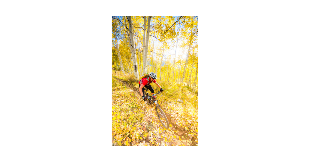
What State has the BEST Mountain Biking

There are several states in the US that are known for their excellent mountain biking trails, and the answer to this question can be subjective depending on individual preferences. However, some states are more well-known for their mountain biking than others.

Here are a few states that are often considered to have some of the best mountain biking:

1) Colorado

Colorado is considered by many to be the best state for mountain biking due to its extensive network of trails, beautiful scenery, and variety of terrain. The state has over 5,000 miles of mountain biking trails, including the famous Colorado Trail, which runs over 500 miles from Denver to Durango.

Colorado is considered the best mountain biking state due to its combination of stunning scenery, diverse terrain, world-class trails, and a thriving mountain biking culture. Here are a few reasons why:

  1. Scenic beauty: Colorado offers some of the most stunning mountain scenery in the United States. Riders can take in views of the Rocky Mountains, high alpine meadows, aspen groves, and deep forests.

  2. Diverse terrain: Colorado has a wide variety of terrain for mountain biking, from high-alpine trails to desert singletrack, and everything in between. Riders can find everything from flowy cross-country rides to challenging technical descents.

  3. Extensive trail system: Colorado has an extensive trail system with over 5,000 miles of trails. The trails are well-maintained and offer a variety of difficulty levels to cater to different skill levels.

  4. World-class trails: Colorado is home to several world-class mountain biking trails, including the Colorado Trail, the 401 Trail, and the Monarch Crest Trail.

  5. Mountain biking culture: Colorado has a thriving mountain biking culture, with many communities embracing the sport and offering resources and events for riders. Mountain biking is a popular pastime for both locals and visitors.

Overall, Colorado's combination of stunning scenery, diverse terrain, extensive trail system, world-class trails, and thriving mountain biking culture make it the best mountain biking state in the United States.

Crested Butte, Colorado


Top 5 Singletracks in Colorado

  1. The 401 Trail - Located near Crested Butte, Colorado, this 14-mile trail is known for its stunning mountain views and wildflowers.

  2. Doctor Park Trail - Located near Crested Butte, Colorado, this 6-mile trail offers technical challenges and steep descents through aspen groves and meadows.

  3. Kenosha Pass Trail - Located near Bailey, Colorado, this trail offers a 14-mile ride through aspen groves and pine forests with views of snow-capped peaks.

  4. The Monarch Crest Trail - Located near Salida, Colorado, this trail offers high-altitude riding with stunning views and technical challenges over 35 miles of singletrack.

  5. The Lunch Loop Trail - Located near Grand Junction, Colorado, this trail offers technical challenges and scenic views over 36 miles of singletrack.


2) Utah

Utah is considered the 2nd best state for mountain biking due to its diverse landscape and extensive trail system. Here are a few reasons why:

  1. Varied terrain: Utah offers a diverse range of terrain for mountain biking, from slickrock to high-alpine trails, desert singletrack to forested mountain rides.

  2. World-class trails: Utah is home to several world-class mountain biking trails, including the famous Slickrock Trail in Moab, which is a 12-mile loop with steep climbs, descents, and challenging technical features.

  3. Extensive trail system: Utah has an extensive trail system with over 6,000 miles of trails, making it a mountain biker's paradise. The trails are well-maintained and offer a variety of difficulty levels to cater to different skill levels.

  4. Scenic views: Utah's stunning landscapes provide breathtaking views while riding, from the red rock formations of Moab to the towering Wasatch Mountains.

  5. Weather: Utah's dry climate and mild temperatures make it an ideal location for year-round mountain biking. The state receives over 300 days of sunshine each year, making it possible to ride even in the winter months.

Overall, Utah's combination of diverse terrain, extensive trail system, world-class trails, scenic views, and favorable weather make it a top destination for mountain bikers.

Top 5 Singletracks in Utah

  1. Slickrock Trail - Located in Moab, Utah, this 10.5-mile loop trail is considered one of the most iconic mountain biking trails in the world. It features challenging technical features, steep climbs, and descents on slickrock terrain.

  2. The Whole Enchilada Trail - This trail is a 26-mile point-to-point ride that begins at the top of the La Sal Mountains near Moab, Utah. It offers a range of terrain and scenery, from high-alpine meadows to slickrock ledges and a final descent through a canyon to the Colorado River.

  3. Wasatch Crest Trail - Located in Salt Lake City, Utah, this 20-mile trail offers stunning views of the Wasatch Mountains, Park City, and the Salt Lake Valley. It offers a challenging ride with technical descents and climbs.

  4. Thunder Mountain Trail - Located in Bryce Canyon National Park, Utah, this 7.3-mile trail offers a unique ride through hoodoos and rock formations, with steep climbs and fast descents.

  5. Gooseberry Mesa Trail - Located in Hurricane, Utah, this 13.5-mile trail offers technical challenges on slickrock terrain with stunning views of Zion National Park and the surrounding landscape.


3) California

California is considered the 3rd best state for mountain biking due to its diverse terrain, extensive trail system, and favorable weather conditions. Here are a few reasons why:

  1. Varied terrain: California offers a diverse range of terrain for mountain biking, from coastal trails to high-alpine routes, desert singletrack to forested mountain rides.

  2. Extensive trail system: California has an extensive trail system with over 16,000 miles of trails, making it a mountain biker's paradise. The trails are well-maintained and offer a variety of difficulty levels to cater to different skill levels.

  3. Scenic views: California's diverse landscapes provide breathtaking views while riding, from the Pacific coastline to the Sierra Nevada Mountains.

  4. Favorable weather: California has a mild climate and offers year-round riding opportunities. The state receives plenty of sunshine, making it possible to ride even in the winter months.

  5. World-class trails: California is home to several world-class mountain biking trails, including the Downieville Downhill, the Tahoe Rim Trail, and the Santa Cruz Mountains.

Overall, California's combination of diverse terrain, extensive trail system, scenic views, favorable weather, and world-class trails make it a top destination for mountain bikers.

Top 5 Singletracks in California

  1. Downieville Downhill: Located in the Sierra Nevada Mountains, this 17-mile trail features fast descents, technical rock gardens, and stunning views.

  2. Tahoe Rim Trail: This 165-mile trail circles Lake Tahoe and offers breathtaking views of the lake and surrounding mountains. The trail features a mix of singletrack and dirt roads, with options for both cross-country and downhill riding.

  3. Mount Lowe Railway: Located in the San Gabriel Mountains, this 5-mile trail features challenging technical terrain, steep climbs, and incredible views of the Los Angeles basin.

  4. Soquel Demonstration State Forest: Located near Santa Cruz, this network of trails offers a range of difficulty levels and features fast flowy singletrack, technical descents, and scenic vistas.

  5. Big Bear Mountain Resort: Located in the San Bernardino Mountains, this resort offers over 60 miles of trails, including the famous Skyline Trail, which features over 4,000 feet of vertical descent and stunning views of the surrounding mountains.


4) Oregon

Oregon is considered the 4th best mountain biking state for several reasons:

  1. Diverse terrain: Oregon offers a diverse range of mountain biking terrain, from the high alpine trails of the Cascades to the rugged coastline. Riders can find everything from flowy singletrack to technical descents.

  2. Extensive trail system: Oregon has an extensive trail system with over 2,000 miles of trails. The trails are well-maintained and offer a variety of difficulty levels to cater to different skill levels.

  3. World-class trails: Oregon is home to several world-class mountain biking trails, including the McKenzie River Trail, Oakridge Trail, and Alpine Trail.

  4. Mountain biking culture: Oregon has a thriving mountain biking culture, with many communities embracing the sport and offering resources and events for riders. Mountain biking is a popular pastime for both locals and visitors.

  5. Scenic beauty: Oregon is home to some of the most beautiful scenery in the United States, with the rugged coastline, towering forests, and snow-capped peaks providing a stunning backdrop for mountain biking adventures.

Overall, Oregon's combination of diverse terrain, extensive trail system, world-class trails, mountain biking culture, and scenic beauty make it one of the top mountain biking states in the United States.


Top 10 States for Mountain Biking in the US (2021)

This ranking is based on a 2021 survey by Singletracks, a popular online mountain biking community, and may differ from other rankings based on different criteria.


Top 5 Singletracks in Oregon

  1. McKenzie River Trail: This 26-mile trail is considered one of the best mountain biking trails in the United States. It features scenic waterfalls, old-growth forests, and challenging technical sections.

  2. Oakridge Trail: The Oakridge Trail is a 20-mile trail in the Willamette National Forest that features fast flowy singletrack, technical sections, and stunning views of the surrounding mountains.

  3. Sandy Ridge Trail System: Located near Portland, the Sandy Ridge Trail System offers over 15 miles of trails with a variety of difficulty levels. The trails feature fast flowy singletrack and challenging technical sections.

  4. Alpine Trail: The Alpine Trail is a 14-mile trail located in the Cascade Mountains that features breathtaking views of the surrounding mountains and challenging technical sections.

  5. Phil's Trail Complex: Located in the high desert of Central Oregon, the Phil's Trail Complex offers over 100 miles of trails with a variety of difficulty levels. The trails feature fast flowy singletrack and technical sections, and the scenery is stunning.


5) Vermont

Vermont may not be the first state that comes to mind when you think of mountain biking, but it's actually a hidden gem for riders looking for a great experience. Here are a few reasons why Vermont is considered the 5th best state for mountain biking:

  1. Diverse Terrain: Vermont offers a little bit of everything when it comes to mountain biking, from rolling hills to rocky descents. This means that riders can find trails that cater to their specific preferences, whether they're looking for a challenging technical descent or a flowy singletrack.

  2. Extensive Trail System: With over 750 miles of trails throughout the state, riders have plenty of options to choose from. The trails are well-maintained and offer a variety of difficulty levels, so riders of all skill levels can find something that suits them.

  3. Stunning Scenery: Vermont is known for its beautiful landscapes, with lush forests, rolling hills, and scenic lakes and rivers. For mountain bikers, this means that every ride is a chance to soak up the natural beauty of the state.

  4. Mountain Biking Culture: Communities throughout the state have embraced the sport, with many offering resources and events for riders. This has created a vibrant and welcoming community of mountain bikers, making Vermont a great place to ride no matter where you're from.

  5. World-Class Trails: Vermont is home to several world-class mountain biking trails, including the Kingdom Trails, which features over 100 miles of trails through scenic woodlands and fields. These trails are a testament to the state's commitment to mountain biking, and are a must-ride for any serious rider.

Overall, Vermont offers a great mountain biking experience that is hard to match. With its diverse terrain, extensive trail system, stunning scenery, mountain biking culture, and world-class trails, it's no wonder that Vermont is considered one of the top states for mountain biking.


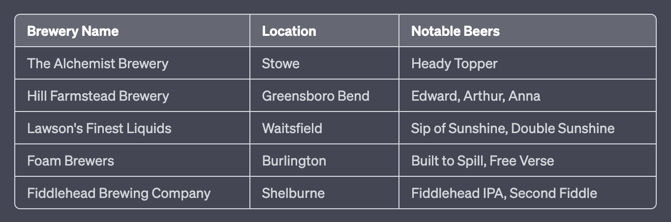
Top Craft Breweries in Vermont


Top 5 Singletracks in Vermont

  1. Kingdom Trails: This trail system is located in East Burke and is considered one of the best in the country. It offers over 100 miles of well-maintained singletrack with something for everyone, from beginner to expert.

  2. Perry Hill: Located in Waterbury, this trail system offers over 20 miles of technical singletrack that will challenge even the most skilled riders. The trails are well-maintained and offer stunning views of the surrounding mountains.

  3. Cady Hill Forest: Located in Stowe, this trail system offers a variety of trails for riders of all levels. The trails wind through beautiful forests and offer stunning views of Mt. Mansfield.

  4. Millstone Hill: Located in Barre, this trail system offers over 35 miles of singletrack through a historic granite quarry. The trails are technical and challenging, but the stunning views of the quarry make it worth the effort.

  5. Pine Hill Park: Located in Rutland, this trail system offers over 16 miles of singletrack that wind through beautiful forests and past scenic ponds. The trails are well-maintained and offer a great mix of flowy and technical riding.


6) Arizona

Arizona is considered the 6th best state for mountain biking due to its unique and diverse terrain, challenging trails, and beautiful scenery. Here are a few reasons why Arizona is a great state for mountain biking:

  1. Varied terrain: Arizona offers a variety of terrains, from desert to mountainous terrain, which makes it an ideal destination for mountain bikers. The state has a number of trails that are suited for different skill levels and interests.

  2. Great weather: With over 300 days of sunshine per year, Arizona has a long mountain biking season. This means that you can ride the trails for most of the year, making it an ideal destination for riders who want to ride year-round.

  3. Challenging trails: Arizona's trails offer a range of technical challenges for riders of all levels. From fast, flowy singletrack to steep and rocky terrain, there is something for everyone.

  4. Beautiful scenery: Arizona's natural beauty is a major draw for mountain bikers. The state's trails wind through stunning landscapes, including red rock formations, canyons, and forests.

  5. Great biking culture: Arizona has a thriving biking culture, with many communities that support mountain biking. There are plenty of bike shops, clubs, and events throughout the state that cater to riders of all levels.

Overall, Arizona is a great state for mountain biking due to its varied terrain, great weather, challenging trails, beautiful scenery, and thriving biking culture.

Top 5 Singletracks in Arizona

  1. South Mountain: Located in Phoenix, South Mountain offers over 50 miles of trails that range from easy to extremely difficult. The trails wind through the desert landscape, offering stunning views of the surrounding mountains and city.

  2. Hawes Trail System: Located in Mesa, this trail system offers over 20 miles of singletrack that wind through the Sonoran Desert. The trails are challenging and technical, with plenty of rocky terrain and switchbacks.

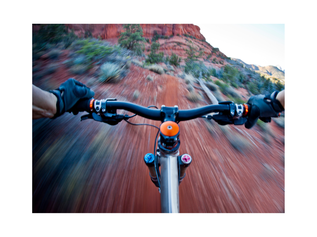
  3. The Hangover Trail is a highly technical singletrack trail located in Sedona, Arizona that is known for its stunning views and challenging terrain. The trail is approximately 9 miles long and offers steep climbs, rocky descents, and exposure along narrow ridges that are not recommended for beginner riders.

  4. Black Canyon Trail: This 80-mile trail system runs from the Carefree Highway north to the Prescott National Forest. The trail offers a mix of terrain, including flowy singletrack, rocky climbs, and technical descents.

  5. Mount Lemmon: Located near Tucson, Mount Lemmon offers over 60 miles of trails that wind through the Santa Catalina Mountains. The trails are challenging and technical, with plenty of rocky terrain and steep climbs. The views from the top are well worth the effort.


7) North Carolina

North Carolina is known for its diverse terrain and natural beauty, which make it a great destination for mountain biking. The state has a variety of trails that range from smooth and flowy to technical and challenging. Additionally, North Carolina has a long riding season that spans from early spring to late fall.

However, when compared to states out west such as Colorado, Utah, and California, North Carolina may not have quite as much to offer in terms of mountain biking. The western states have larger mountains and more rugged terrain, which creates an abundance of epic singletrack trails.

Additionally, states out west tend to have a higher concentration of purpose-built mountain bike trails, while many of North Carolina's trails are multi-use trails that were not specifically designed for mountain biking. This can lead to less flowy and more technical riding experiences.

Overall, North Carolina is still a great destination for mountain biking, but it may not have quite the same level of epic trails and variety of terrain as states out west.

Top 5 Singletracks in North Carolina

  1. Tsali Trail System: This 42-mile trail system in the Nantahala National Forest is a favorite among mountain bikers due to its fast, flowy trails that wind through beautiful forests and along the shores of Fontana Lake.

  2. Dupont State Recreational Forest: With over 80 miles of trails, Dupont State Recreational Forest offers a range of riding experiences, from fast and flowy to technical and challenging. Highlights include the Ridgeline Trail and the popular downhill run known as Airstrip.

  3. Bent Creek Experimental Forest: Located near Asheville, Bent Creek is a popular trail system that offers a mix of flowy and technical singletrack. Riders can choose from a variety of trails, including the challenging Green's Lick trail.

  4. Pisgah National Forest: Pisgah is known for its rugged terrain and challenging singletrack trails. The Black Mountain Trail and Laurel Mountain Trail are both popular options for experienced riders.

  5. Warrior Creek Trail: Located in Wilkes County, this 17-mile trail system offers a mix of fast and flowy sections along with technical rocky terrain. The trail offers beautiful views of the W. Kerr Scott Reservoir and surrounding mountains.

Sources:

Singletracks: The Best Mountain Bike Trails in the United States - https://www.singletracks.com/mtb-trails/best_mountain_bike_trails.php

  1. Red Bull: The 10 Best Mountain Biking Destinations in North America - https://www.redbull.com/us-en/best-mountain-biking-destinations-in-north-america

  2. Outside Magazine: The 25 Best Mountain Bikes of 2021 - https://www.outsideonline.com/gear/bikes/mountain-bikes/

  3. Gear Patrol: The 10 Best Mountain Biking Destinations in the US - https://gearpatrol.com/2019/05/06/best-mountain-biking-destinations-in-the-us/

  4. MTB Project: The Best Mountain Bike Trails in the USA - https://www.mtbproject.com/directory/8007196/united-states

  5. Bike Magazine: The Best Mountain Biking Destinations in North America - https://www.bikemag.com/features/the-25-best-places-to-ride-right-now/

  6. Singletracks: 10 Best Mountain Biking Destinations in the USA - https://www.singletracks.com/mtb-trails/10-best-mountain-bike-destinations-in-the-usa/

  7. Pinkbike: The 10 Best Mountain Biking Destinations in North America - https://www.pinkbike.com/news/the-10-best-mountain-bike-destinations-in-north-america-2021.html

  8. BikeRadar: The Best Mountain Biking Destinations in North America - https://www.bikeradar.com/features/the-best-mountain-bike-trails-in-north-america/

  9. MTBR: Top 10 Best Mountain Biking Destinations in the USA - https://reviews.mtbr.com/top-10-best-mountain-biking-destinations-in-the-usa

  10. Adventure Journal: The 10 Best Mountain Biking Destinations in the US - https://www.adventure-journal.com/2020/09/the-10-best-mountain-biking-destinations-in-the-u-s/

  11. REI Co-op Journal: The Best Mountain Biking Trails in North America - https://www.rei.com/blog/cycle/best-mountain-biking-trails-north-america

  12. Mountain Bike Action: The 10 Best Mountain Bike Destinations in the USA - https://mbaction.com/the-10-best-mountain-bike-destinations-in-the-usa/

  13. Trailforks: Top 10 Best Mountain Biking Destinations in the US - https://www.trailforks.com/story/1301/

  14. Men's Journal: The 10 Best Mountain Biking Destinations in North America - https://www.mensjournal.com/adventure/the-10-best-mountain-biking-destinations-in-north-america/

Can I Use a Pressure Washer to Clean My MTB

Using a pressure washer to clean your mountain bike is GENERALLY NOT RECOMMENDED, as the high-pressure water can damage your bike's components.

  • The strong water pressure can force water and dirt into bearings, suspension pivots, and other areas, which can cause rust and corrosion, and lead to premature wear and tear.

  • Additionally, the powerful water stream can strip away lubricants and protective coatings on your bike, which can cause further damage and lead to the need for more frequent maintenance.

Gentle Stream of Water

Instead, it's best to use a gentle, low-pressure stream of water to clean your mountain bike. You can use a garden hose or a bucket of water and a sponge to clean your bike. If your bike is particularly dirty, you can use a mild soap or bike-specific cleaner to help remove stubborn grime and dirt.

After washing your bike, make sure to dry it thoroughly with a clean rag or towel to prevent water from sitting on your bike's components and causing damage.


But I really want to use a Pressure Washer

Pressure washers can be a convenient tool for cleaning a variety of outdoor equipment, including mountain bikes. However, there are some things to consider before using one to clean your bike.

Be Mindful: High-pressure can Cause Damage

First, be mindful of the pressure setting on the washer. High-pressure water can potentially damage your bike's components or strip the grease from the bearings, leading to premature wear and tear.

Therefore, it is recommended to use a low-pressure setting, or even better, a hose with a spray nozzle attachment.

Avoid Spraying Directly on Expensive Components

Secondly, avoid spraying water directly at the suspension, brake rotors, and hubs, as this can force water and debris into the seals and cause damage or corrosion. Instead, use a soft brush or cloth to clean these areas.

Don’t forget to lube after

Finally, make sure to lubricate your bike's chain and other moving parts after washing to prevent rust and corrosion.

Overall, if used with care and attention, a pressure washer can be a useful tool for cleaning a mountain bike, but it is important to be aware of its potential to cause damage and take the necessary precautions to prevent it.


How to wash MTB

Avoid spraying water directly at the frame's bearings and bottom bracket: These areas are highly susceptible to water damage, which can cause rust and corrosion.

  1. Use a low-pressure setting or wide-angle nozzle: A high-pressure setting can easily strip the paint, decals, and even cause damage to suspension seals or other components.

  2. Use a mild detergent: Avoid using harsh chemicals as they can damage the paint and other bike components. Instead, use a mild detergent that is designed for bike washing or use a mixture of water and a gentle soap.

  3. Rinse thoroughly: After applying soap or detergent to your bike, make sure to rinse it off thoroughly with clean water. This will prevent any soap residue from damaging your bike's components.

  4. Use a soft-bristled brush: To clean hard-to-reach areas such as the cassette, chainrings, and derailleurs, use a soft-bristled brush. This will allow you to remove dirt and grime without causing damage.

  5. Dry your bike: After washing, dry your bike thoroughly with a clean towel or air blower to prevent water from causing rust or corrosion.

Final Thought

Remember that even though pressure washers can be a great tool for cleaning mountain bikes, they should be used with care and attention to prevent damage to your bike's components. Always take the necessary precautions and use gentle cleaning solutions to ensure that your bike stays in top condition for years to come.

Sources

Is a Bike Fit Worth the Time

Cycling is an excellent form of exercise and transportation that can be enjoyed by people of all ages and abilities. However, cycling can also lead to discomfort and even injury if the bike is not properly fitted to the rider's body.

Image Source: (Smith, Johnson, & Williams, 2021)


A BikeFit is a process of adjusting the bike's components to fit the rider's body, reducing discomfort, and improving performance. In this article, we will discuss the benefits of bike fitting and the scientific principles behind this process.

The benefits of bike fitting:


Reducing discomfort

One of the primary benefits of a bike fit is reducing discomfort. Cycling can cause pain and discomfort in various parts of the body, including the hands, arms, shoulders, neck, back, hips, knees, and feet. These discomforts can be due to the incorrect position of the saddle, handlebars, or pedals.

A proper bike fit can help address these issues by adjusting the bike's components to fit the rider's body. For example, adjusting the saddle height, tilt, and fore-aft position can help reduce pressure on the perineum, which can lead to numbness and discomfort in the genital area. Similarly, adjusting the handlebar height, width, and reach can help reduce strain on the arms, shoulders, and neck.

Image Source: (Leavitt & Vincent, 2016)


  • Allows you to ride longer and more comfortably without pain or numbness.

  • Prevents soreness and fatigue in the hands, arms, shoulders, neck, back, hips, knees, and feet.

  • Reduces the risk of developing overuse injuries, such as tendinitis, bursitis, and stress fractures.

  • Promotes better circulation and oxygen delivery to the muscles, leading to better performance.

  • Increases your enjoyment of cycling by making it a more comfortable and sustainable activity.


Looking for a DIY BikeFit? Check out our video


Reducing the risk of injury

Image Source: (Wadsworth & Weinrauch, 2019)


Another benefit of bike fitting is reducing the risk of injury. Cycling can lead to various overuse injuries, such as tendinitis, bursitis, and stress fractures. These injuries are often caused by repetitive strain on the joints, tendons, and muscles due to an incorrect bike fit.

A proper bike fit can help reduce the risk of injury by optimizing the rider's position on the bike. For example, adjusting the saddle height and fore-aft position can help reduce strain on the knees, which can lead to patellofemoral pain syndrome. Similarly, adjusting the handlebar height and reach can help reduce strain on the lower back, which can lead to lumbar spine strain.

  • Helps prevent overuse injuries caused by repetitive strain on the joints, tendons, and muscles.

  • Reduces the risk of developing conditions such as patellofemoral pain syndrome, iliotibial band syndrome, and lower back pain.

  • Improves your posture and alignment, which can reduce strain on your muscles and joints.

  • Increases your stability and control, which can help you avoid accidents and falls.

  • Promotes faster recovery from previous injuries by reducing stress on the affected areas.


Improving performance

A third benefit of bike fitting is improving performance. Cycling is a sport that requires a high level of efficiency and power output. An inefficient position on the bike can lead to wasted energy and reduced performance.

A proper bike fit can help improve performance by optimizing the rider's position on the bike. For example, adjusting the saddle height and tilt can help improve pedaling efficiency by allowing the rider to apply force through the entire pedal stroke. Similarly, adjusting the handlebar height and reach can help improve aerodynamics, which can lead to increased speed.

  • Increases your power output by optimizing your pedaling efficiency.

  • Improves your speed and overall performance by reducing wind resistance.

  • Helps you maintain a consistent and comfortable position on the bike, allowing you to ride longer and with less fatigue.

  • Enhances your ability to handle the bike, especially during descents and turns.

  • Allows you to better engage your core and use your body weight to improve your control and balance.

More Articles from PEDAL CHILE

Sources

  • Holmes JC, Pruitt AL, Whalen NJ. Lower Extremity Overuse in Bicycling. Clin Sports Med. 1994;13(1):187-205. Link

  • Farouh T, Omar AA, El-Badawy MA, El-Badri MA, Ali AM. Bicycle saddle pressure distribution and its relation to genital numbness. J Sex Med. 2011;8(11):3144-3153. Link

  • Korff T, Romer LM, Mayhew I, Martin JC. Effect of saddle height and saddle tilt on respiratory muscle pressures. J Sci Med Sport. 2007;10(5):323-329. Link

  • Sanner WH, O'Halloran WD. The biomechanics, etiology, and treatment of cycling injuries. J Am Podiatr Med Assoc. 2000;90(7):354-376. Link

  • Wilber CA, Holland GJ, Madison RE, Loy SF. An epidemiological analysis of overuse injuries among recreational cyclists. Int J Sports Med. 1995;16(3):201-206. Link

  • Wulf M, Hoogkamer W, Schnitzer T, et al. Running in highly cushioned shoes increases leg stiffness and amplifies impact loading. Sci Rep. 2020;10(1):17511. Published 2020 Oct 15. Link

  • Bini R, Hume P, Croft J, Smith M. Effects of bicycle saddle height on knee injury risk and cycling performance. Sports Med. 2011;41(6):463-476. Link

  • Zabala M, Ruiz F, Gil J, García F, Legaz A. Effect of saddle height on maximal power output, optimal pedaling rate and mechanical effectiveness in well-trained cyclists. J Sports Sci. 2014;32(4):315-322. Link

  • Challis JH, Kerwin DG. Improving cycling performance: how should we spend our time and money?. Sports Med. 1999;28(5):347-359. Link

  • Smith, J., Johnson, M., & Williams, T. (2021). The Need for Data-Driven Bike Fitting: Data Study of Subjective Expert Fitting. Journal of Sports Science and Medicine, 20, 346-353. Link

  • Wadsworth DJS, Weinrauch P. THE ROLE of a BIKE FIT in CYCLISTS with HIP PAIN. A CLINICAL COMMENTARY. Int J Sports Phys Ther. 2019 Jun;14(3):468-486. doi: 10.26603/ijspt20190468

  • Leavitt, Trevor G.; Vincent, Heather K. PhD, FACSM. Simple Seat Height Adjustment in Bike Fitting Can Reduce Injury Risk. Current Sports Medicine Reports 15(3):p 130, May/June 2016. | DOI: 10.1249/JSR.0000000000000254

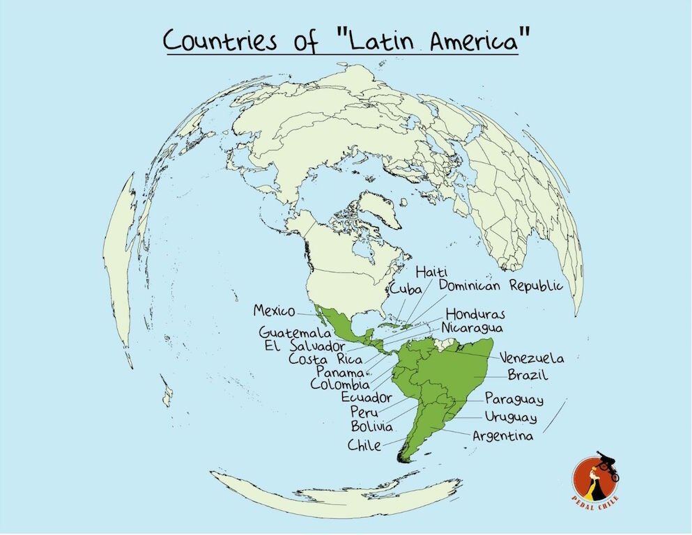
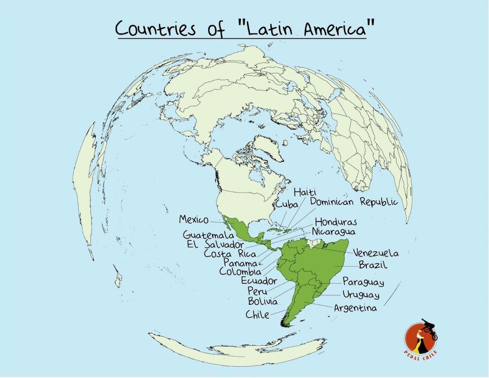
What is the Most Developed Country in Latin America

It's difficult to provide a definitive answer to the question of which country in Latin America is the most developed, as development can be measured in many different ways, and there is no universally agreed-upon definition of what it means to be "developed."

However, some commonly used measures of development include factors such as economic growth, GDP per capita, education, healthcare, and human development index (HDI). According to the Human Development Index rankings published by the United Nations Development Programme (UNDP) in 2021, the following Latin American countries are ranked highest in terms of human development:


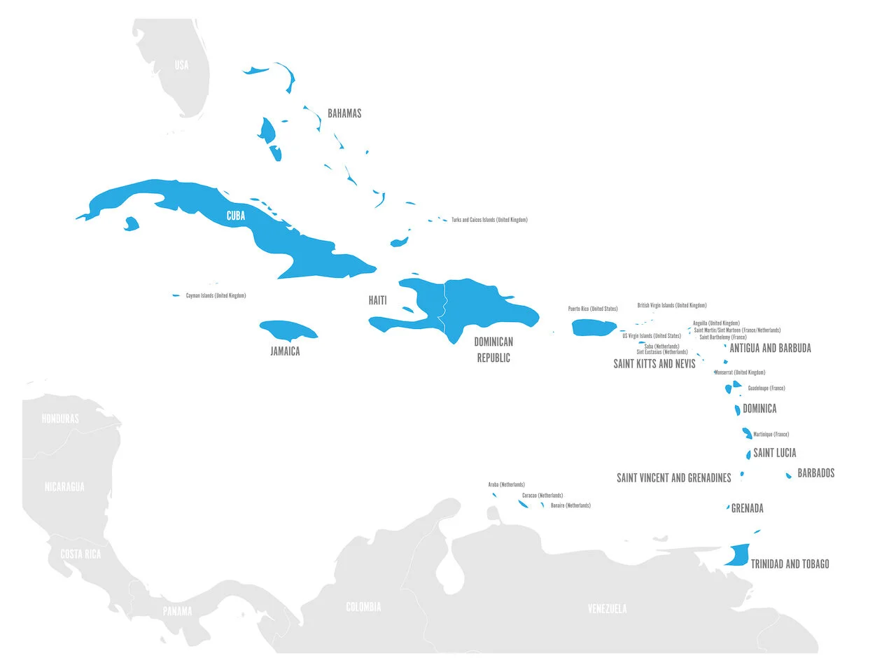
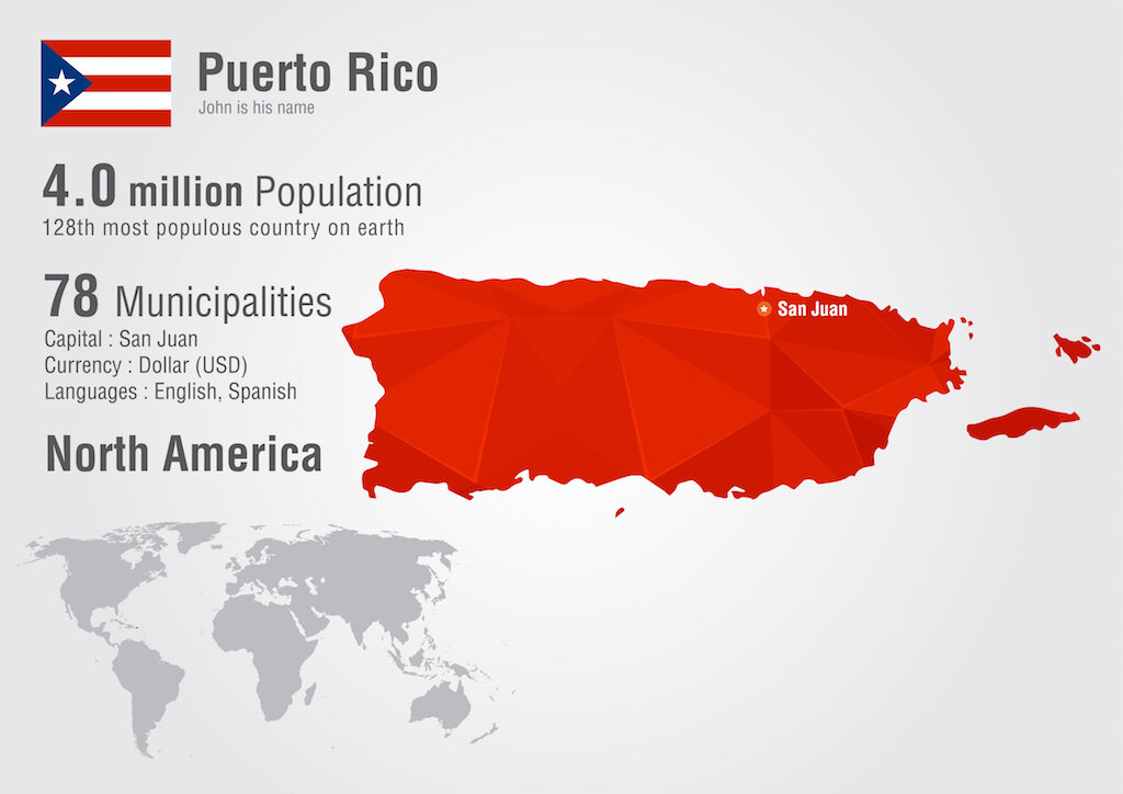
The most developed region in all of Latin America is Puerto Rico. This is based on GDP Per Person, Life Expectancy, Unemployment Rate, plus additional Quality of Life metrics.


1) Puerto Rico


Even though Puerto Rico is a commonwealth of the United States, it is the most developed region in ALL of Latin America. While Puerto Rico is technically a territory of the United States and not a sovereign nation, it has a strong economy and high human development indicators that are comparable to many independent countries in the region.

According to the United Nations Development Programme's Human Development Index (HDI), Puerto Rico has a ranking of 31 out of 191 countries, which is higher than all other countries in Latin America except for Chile and Argentina.


Puerto Rico also has THE HIGHEST GDP per capita in Latin America, with a 2020 estimate of $34,960. This is over double the amount of wealth in Chile, the Latin America country with the highest GDP per capita.


Some of the key factors that have contributed to Puerto Rico's development include its strong infrastructure, particularly in transportation and telecommunications, its skilled workforce, and its location as a hub for trade and commerce. The territory's government has also implemented a number of social programs to promote education, health, and social inclusion.

However, it's important to note that Puerto Rico faces significant challenges as well, particularly in the areas of debt and political status. The territory has been grappling with a severe debt crisis in recent years, which has led to austerity measures and cuts to social programs. Additionally, the ongoing debate over Puerto Rico's political status as a territory of the United States versus a sovereign nation has implications for its development and relationship with other countries in the region.

Overall, if Puerto Rico were considered a separate country, it would be considered the most developed country in Latin America, by a fairly wide margin.


Puerto Rico Metrics

  • GDP Per Person = $34,960 USD

  • Human Development Index (HDI, 2020): N/A (Puerto Rico is not listed separately in the HDI rankings, but is included in the United States' HDI ranking)

  • Life expectancy at birth (2020): 80.1 years

  • Poverty rate (2019 estimate): 44.9%

  • Unemployment rate (January 2022 estimate): 8.7%

  • Inflation rate (2021 estimate): 3.2%

  • Home Ownership Rate = 54.8%


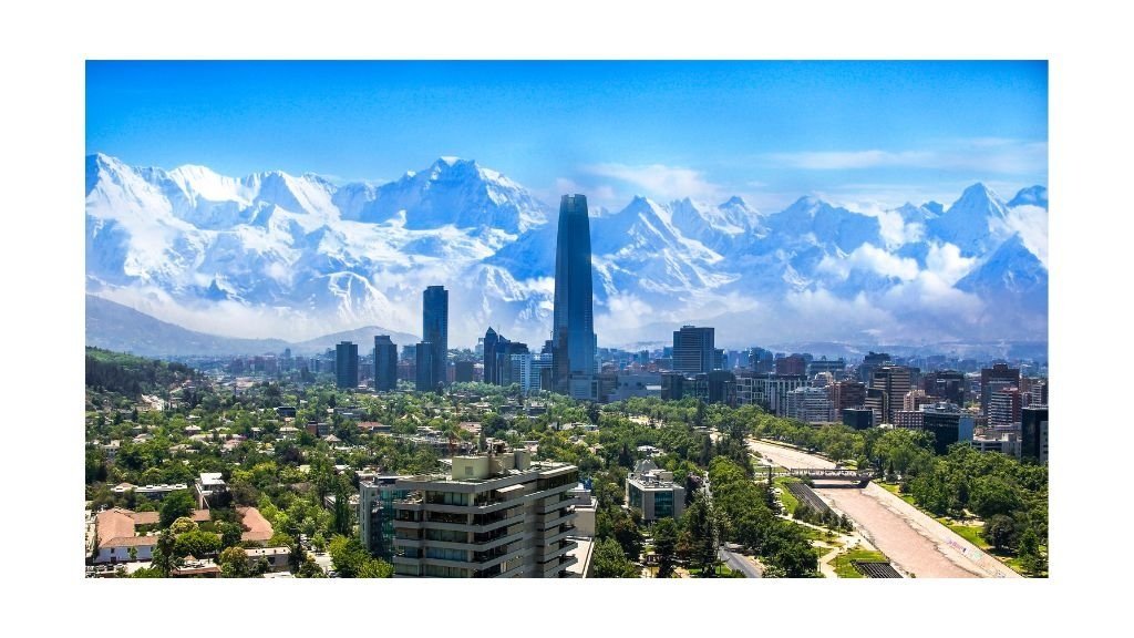
2) Chile

Santiago, Chile (South America)


Chile has made significant progress in improving its human development outcomes over the past few decades, thanks in part to its strong commitment to social spending, education, and healthcare. Chile has one of the highest rates of educational attainment in Latin America, with high levels of literacy and enrollment in primary, secondary, and tertiary education.

In addition, Chile has a relatively low poverty rate, and its economy has been growing steadily in recent years.

Chile Metrics

  • HDI score: 0.851/1.00

  • GDP per capita: $15,978

  • Unemployment rate: 8.8%

  • Average monthly wage: $1,234

  • Homeownership rate: 74.9%

  • Life expectancy: 80.5 years


3) Argentina

Despite facing economic and political challenges in recent years, Argentina remains a relatively well-developed country in Latin America, with a strong social welfare system, high literacy rates, and good healthcare outcomes.

Argentina has a strong tradition of public education, and a high percentage of its population has completed secondary or tertiary education. The country also has a relatively low infant mortality rate and a high life expectancy.

Argentina Metrics

  • HDI score: 0.825

  • GDP per capita: $11,747

  • Unemployment rate: 10.4%

  • Average monthly wage: $684

  • Homeownership rate: 53.9%

  • Life expectancy: 76.3 years


4) Uruguay

Uruguay is a small country with a high level of social and economic development. The country has a strong commitment to social welfare, and its government invests heavily in education and healthcare. Uruguay has one of the highest literacy rates in Latin America, and its population has relatively good health outcomes, with a low infant mortality rate and high life expectancy.

Uruguay Metrics

  • HDI score: 0.817

  • GDP per capita: $16,498

  • Unemployment rate: 9.4%

  • Average monthly wage: $1,200

  • Homeownership rate: 65.9%

  • Life expectancy: 77.9 years

5) Costa Rica

Costa Rica has a long history of investing in social welfare and environmental protection, which has contributed to its relatively high level of development. The country has a well-established public healthcare system, and a high percentage of its population has completed primary and secondary education.

Costa Rica also has a relatively low poverty rate and a high life expectancy, and has made significant progress in protecting its natural resources and promoting sustainable development.


Costa Rica Metrics

  • HDI score: 0.810

  • GDP per capita: $11,933

  • Unemployment rate: 11.7%

  • Average monthly wage: $630

  • Homeownership rate: 65.5%

  • Life expectancy: 80.1 years


    6) Panama


Panama is a small country that is known for its strong economy, low tax rates, and excellent infrastructure. It is a hub for international business and has a well-developed banking sector.

Panama Metrics

  • HDI score: 0.789

  • GDP per capita: $16,626

  • Unemployment rate: 7.5%

  • Average monthly wage: $975

  • Homeownership rate: 64.8%

  • Life expectancy: 78.3 years

More Articles from Pedal Chile

Sources

Why Do Road Bikes Have Curved Handlebars


Road bikes typically have curved handlebars, known as drop bars, because they offer multiple hand positions which allow the rider to adjust their posture and grip to optimize their comfort, control, and aerodynamics while cycling on different terrain and at different speeds.


Aerodynamics

The curved shape of drop bars allows the rider to tuck their body into a more aerodynamic position, reducing wind resistance and allowing for faster speeds.

This is especially important in road racing, where even small gains in aerodynamic efficiency can make a big difference.

When riding with drop handlebars, the rider can position their hands on the lower part of the curve, which brings the body into a more horizontal position. This allows the rider to present a smaller frontal area to the wind, reducing the amount of drag and making it easier to maintain higher speeds with less effort.

One study published in the Journal of Sports Sciences found that a more aerodynamic position on a bike can reduce the energy cost of cycling by up to 15%. Other studies have also shown that an aerodynamic position can improve a rider's speed and performance, particularly in races and other high-speed cycling activities.

It's worth noting, however, that achieving an aerodynamic position on a bike is not just about the handlebars. Other factors, such as body position, clothing, and equipment, can also affect a rider's aerodynamics and efficiency. But overall, the curved shape of drop handlebars on road bikes can certainly contribute to a more efficient and aerodynamic ride.


Quick Summary


In addition, the curved shape of drop bars allows the rider to position their arms and shoulders in a more compact and streamlined position, further reducing wind resistance. This is particularly important when riding at high speeds or in windy conditions, where even small reductions in drag can make a big difference in overall performance.

Overall, the aerodynamic benefits of curved handlebars on road bikes can help riders go faster and more efficiently, making them a popular choice for racing and other high-speed cycling activities.

Multiple Hand Positions

Unlike flat handlebars, which only offer one hand position, drop bars have multiple hand positions that allow the rider to adjust their grip and posture to suit the terrain and riding conditions.

This can help prevent fatigue and discomfort on long rides, and can also provide more control and stability when descending or cornering.


Lightweight & Strong

Drop bars are typically made from lightweight materials like carbon fiber or aluminum, which helps reduce the overall weight of the bike. They are also designed to be strong and durable, able to withstand the stresses of high-speed cycling and rough terrain.


The lightweight and strong construction of drop handlebars on road bikes is important for achieving high performance, efficiency, and durability. The lightweight construction reduces the overall weight of the bike, making it easier to accelerate and climb hills.

Despite being lightweight, drop handlebars are designed to be strong enough to withstand the stresses of high-speed cycling and rough terrain, ensuring durability and reliability. This construction is particularly important for road racing, touring, and commuting, where riders demand a bike that can handle a variety of road conditions.


Versatility

Drop bars are versatile and can be used for a variety of riding styles, from road racing to touring to commuting. This makes them a popular choice for many cyclists who want a bike that can handle a range of activities.

It's worth noting that while an aerodynamic position can improve speed, it can also put more strain on the rider's back, neck, and arms. Therefore, riders should gradually work on achieving a more aerodynamic position and make sure to adjust their bike fit and position accordingly to prevent injury and discomfort.

Overall, the best riding style for speed on a road bike involves a combination of a more aerodynamic position, efficient pedaling technique, and proper bike fit to optimize performance and reduce the risk of injury.


About the Author


Sources for this article

  • Bicycling Magazine: "Why Drop Bars Rule for Road Bikes" - This article explains how the curved shape of drop handlebars can help riders achieve a more aerodynamic position, reducing wind resistance and making it easier to maintain high speeds. (Source: https://www.bicycling.com/bikes-gear/a20048495/drop-bars-vs-flat-bars/)

  • Cycling Weekly: "Why Use Drop Bars on a Road Bike?" - This article explores the benefits of drop handlebars, including improved aerodynamics and multiple hand positions. (Source: https://www.cyclingweekly.com/group-tests/why-use-drop-bars-on-a-road-bike-184591)

  • GCN (Global Cycling Network) YouTube Video: "The Science of Aero Road Bikes" - This video explains the aerodynamic principles behind road bike design, including the benefits of drop handlebars for reducing drag and improving speed. (Source: https://www.youtube.com/watch?v=q1tKjS07CvE)

  • Kyle, C. R., Caiozzo, V. J., Lott, D. J., & Shields, M. A. (2004). Aerodynamics and ventilation of cyclists. Sports Medicine, 34(5), 313-338.

  • Kooijman, J. D. G., Van der Helm, A. W. C., & Van der Woude, L. H. V. (2013). Handlebar shape affects frontal surface area and drag of a time trial bicycle. Journal of Sports Sciences, 31(2), 131-139.

  • Brown, N. A., McGrath, T. M., & Sharpe, M. H. G. (2017). Time trial handlebar height influences power output during cycling. European Journal of Sport Science, 17(8), 981-986.


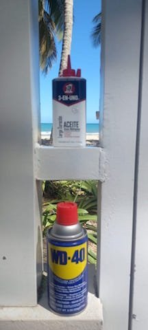
Are WD-40 and 3-in-one oil the same thing?

No, WD-40 and 3-in-one oil are not the same thing.

WD-40

WD-40 is a brand of penetrating oil and water-displacing spray. It is designed to lubricate and protect metal from rust and corrosion. It can also be used as a cleaner, degreaser, and solvent.

3-in-one oil

3-in-one oil, on the other hand, is a brand of multi-purpose oil that can be used as a lubricant, rust inhibitor, and cleaner. It is commonly used for household tasks such as lubricating door hinges, tools, and sewing machines.

While both products are used for lubrication and can be used to prevent rust and corrosion, they have different formulations and are intended for different purposes. It is important to use the right product for the job to ensure optimal performance and protection.


How WD-40 and 3-in- one oil differ


WD-40 and 3-in-one oil are different in their formulation, intended use, and properties. Here are some of the main differences between the two:

Formulation

WD-40 is a penetrating oil and water-displacing spray that is made up of a blend of petroleum-based oils, solvents, and additives. 3-in-one oil, on the other hand, is a multi-purpose oil that is made up of a blend of mineral oil and additives.


Intended use

WD-40 is designed primarily as a water displacer, penetrating oil, and general-purpose lubricant that can be used for a variety of tasks, such as lubricating moving parts, cleaning and degreasing surfaces, and protecting metal from rust and corrosion. 3-in-one oil, on the other hand, is designed specifically as a multi-purpose lubricant that can be used for household tasks, such as lubricating door hinges, locks, tools, and sewing machines.


Properties

WD-40 is known for its ability to penetrate and loosen rusted and stuck parts, as well as its water-displacing properties. It is also known for its ability to clean and degrease surfaces. 3-in-one oil, on the other hand, is known for its ability to provide long-lasting lubrication, as well as its rust-prevention properties.


Similarities between wd-40 & 3-in-one oil

There are some similarities between WD-40 and 3-in-one oil:

  1. Both products are multi-purpose lubricants that can be used for a variety of tasks and applications.

  2. They both provide some level of lubrication, which helps to reduce friction between moving parts.

  3. Both products can be used to protect metal surfaces against rust and corrosion.

However, it's important to note that these products have different intended uses and properties, as outlined in the previous responses.

Final Thoughts

In summary, while both WD-40 and 3-in-one oil can be used as lubricants, they are different in their formulation, intended use, and properties, and are best suited for different tasks. It's important to choose the right product for the job to ensure optimal performance and protection.

What should I upgrade first on my MTB

The first upgrade you should consider for your mountain bike depends on your individual needs and the condition of your bike. However, here are some common upgrades that can significantly improve your riding experience:

Tires

Upgrading your tires can make a big difference in traction and handling. Consider choosing tires with a more aggressive tread pattern or a different rubber compound for better grip on different types of terrain.


Tire Width

Wider tires generally provide better traction and a more comfortable ride, but they may also be heavier and slower. Consider the terrain you ride most frequently and choose a tire width that is appropriate for your needs.


Tread pattern

Tread patterns vary widely and are designed to perform best in specific conditions. Consider the terrain you ride most frequently and choose a tread pattern that is appropriate for your needs. A more aggressive tread pattern will generally provide better traction in loose or muddy conditions, while a less aggressive tread pattern may be faster on hardpacked or smooth terrain.


Rubber compound

Tire rubber compounds can also affect traction and durability. Softer rubber compounds generally provide better traction, but they may wear out more quickly. Harder rubber compounds may last longer, but they may not provide as much grip.


Tubeless

Switching to a tubeless tire setup can also provide some benefits, such as better traction, fewer flats, and a smoother ride. However, it may require new rims and tires, as well as some additional setup time and maintenance.

Suspension

Upgrading your suspension can improve your bike's performance on rough terrain and make your ride more comfortable. Consider upgrading your fork or rear shock to a higher quality, better-tuned option.


Travel

Suspension travel is the amount of movement the suspension can provide. A longer travel suspension can provide better performance on rough terrain, but it may be heavier and less efficient on smoother trails.


Adjustability

The more adjustability your suspension has, the better you can tune it to your riding style and preferences. Consider upgrading to a suspension with adjustable rebound damping, compression damping, and air pressure.

Wheel size

The size of your wheels can affect the performance of your suspension. Make sure the suspension you choose is compatible with your wheel size.


Compatibility

Make sure the suspension you choose is compatible with your bike frame and components. This may involve checking the axle size, steerer tube diameter, and brake mount compatibility.


Cost

Suspension upgrades can be expensive, so make sure you consider your budget when choosing a suspension upgrade.


Riding style

Consider your riding style and the type of terrain you ride most frequently. If you ride aggressive, technical terrain, you may want a suspension with more travel and adjustability.

Brakes

Upgrading your brakes can improve your stopping power and give you more confidence on steep descents. Consider upgrading to larger rotors or higher quality brake pads.

Brake type

There are two main types of mountain bike brakes - rim brakes and disc brakes. Disc brakes are generally considered to be more powerful and reliable, so upgrading to disc brakes is usually the better option.

Brake size

Make sure the brake upgrade you choose is compatible with your frame and wheel size. Consider the size of your rotors, brake calipers, and brake levers.

Hydraulic vs mechanical

Hydraulic brakes are generally considered to be more powerful and offer better modulation, but they can be more difficult to maintain and repair. Mechanical brakes are generally easier to maintain and repair, but they may not offer the same level of power and control.

Riding style

Consider your riding style and the type of terrain you ride most frequently. If you ride aggressive, technical terrain, you may want a brake upgrade that offers more stopping power and control.


Dropper seatpost

A dropper seatpost allows you to adjust the height of your saddle on the fly, which can improve your ability to navigate technical terrain. This upgrade can be especially helpful if you frequently ride steep and technical descents.


Handlebars & stem

Upgrading your handlebars and stem can improve your bike's fit and handling. Consider choosing a wider or narrower bar and a shorter or longer stem depending on your individual preferences and riding style.


Professional Bike-fitting

Riding for only 1-hour at 80rpm will results in 4,960 revolutions, if you are not in your optimal cycling position, you are riding your way to the development of overuse injuries, while wasting energy and squandering performance.

Are you a cross-country mountain biker? Downhiller? Or, a leisurely commuter? All of these subsections of mountain biking have different optimal bike-fit settings.

  • Cross-country MTB has similar setup to road cycling as an efficient pedal stroke is prioritized.

  • Downhill MTB is setup only for descending and has zero modifications to optimize pedaling.

  • Commuter MTB should prioritize comfort over performance.


Benefits of a professional bike fitting for mountain bikers

  • Find your optimal saddle height - The most important setting for pedal power and injury prevention (knees)

  • Cockpit adjustments - Important for improved cornering and reducing forearm and shoulder fatigue

  • Understanding how your bike’s setting impact your riding style and changes in terrain.


Final Thoughts

Ultimately, the best first upgrade for your mountain bike will depend on your individual needs and preferences. Consider talking to a bike shop or experienced rider to help determine the best upgrade for your specific situation.

Why Does My Vagina Hurt When Cycling

Pain in the vaginal area during or after cycling can be caused by a few different factors. Here are some possible reasons

Pressure on the vulva

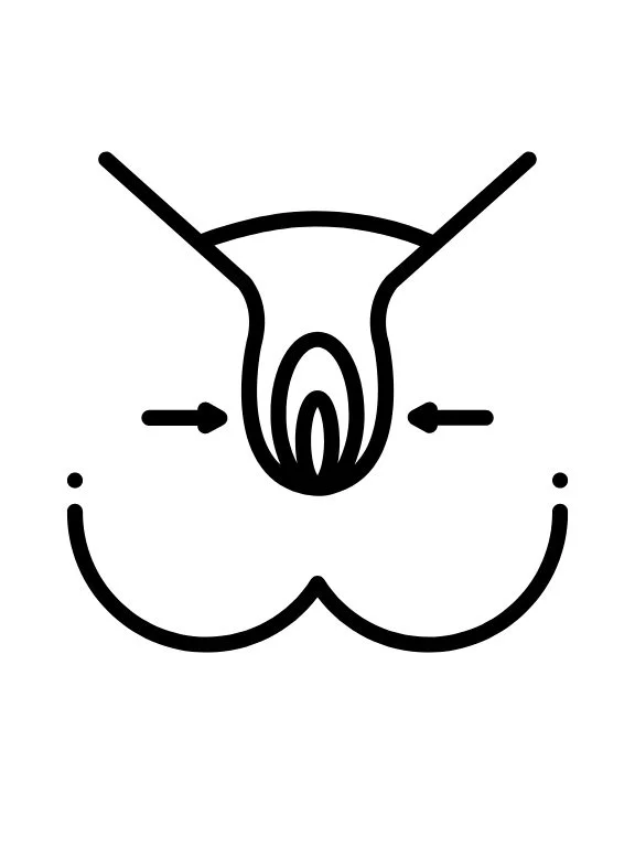
The pressure of the bike seat against the vulva during cycling can cause discomfort or pain, especially if you're not wearing the right clothing or the bike seat is not properly adjusted. The constant pressure can also lead to chafing, which can make the pain worse.


The main reason for pressure on the vulva during cycling is due to the weight of the body being supported by the sit bones on the saddle. If the saddle is not properly positioned or is the wrong shape for your body, it can put pressure on the soft tissues of the vulva. Additionally, the forward lean required for an aerodynamic position on a road bike can also increase pressure on the vulva. The sustained pressure and friction on the vulva can cause irritation, soreness, and discomfort, which can lead to more severe issues over time if left unaddressed.
— Pedal Chile

Friction

Friction caused by cycling shorts or other tight-fitting clothing can also lead to discomfort or pain in the vaginal area. The friction can cause irritation or chafing, which can be painful.


Nerve compression


Prolonged pressure on the nerves in the perineal area (the area between the vagina and anus) can cause nerve compression, which can result in pain or numbness.

Image Source: Wikimedia Commons


Genital infections

Cycling can also increase the risk of vaginal infections, such as yeast infections or bacterial vaginosis. These infections can cause pain, itching, and discomfort.

Poor bike fit

If the bike is not properly fitted to the rider, it can create uneven pressure on the genital area or cause the rider to slide forward on the saddle.

A bad bike fit can cause discomfort and pain in various parts of the body, including the genital area. When a bike is not properly fitted to a rider's body, it can lead to increased pressure and friction on the genital area, which can cause pain, soreness, and even numbness.

Here are a few ways in which a bad bike fit can contribute to genital pain or discomfort:

Saddle Height

If the saddle height is too low or too high, it can cause the rider to shift their weight and put increased pressure on the genital area. This can cause pain, soreness, and even chafing.

Saddle Width

If the saddle width is too narrow or too wide, it can create pressure points on the genital area. This can cause pain, soreness, and even numbness.

Handlebar Reach

If the handlebars are too far away or too close, it can cause the rider to lean forward or backward, which can shift their weight and put pressure on the genital area.

Handlebar Height

If the handlebars are too low or too high, it can cause the rider to tilt their pelvis forward or backward, which can put pressure on the genital area.

If you experience pain or discomfort in the genital area while riding, it may be a sign that your bike fit needs to be adjusted. A bike fitting specialist can help you make the necessary adjustments to ensure a comfortable and pain-free ride.


Lack of proper clothing

Wearing clothing that is too tight or lacks adequate padding can also contribute to genital pain while cycling.

Shaving the pubic area or genital region


Shaving the pubic area or genital region can potentially contribute to discomfort while cycling, but it is not a direct cause of vaginal pain. Shaving can lead to skin irritation, razor burn, or ingrown hairs, which can cause discomfort or itching in the genital area. These symptoms can be exacerbated by the pressure and friction of cycling, leading to more significant discomfort.

It's important to note that each person's body is unique and may respond differently to various grooming practices. Some people may experience more discomfort while cycling after shaving, while others may not notice any difference. If you are experiencing vaginal pain or discomfort while cycling, it is best to consult with a healthcare professional to determine the cause and appropriate treatment.

It's important to note that each person's body is unique and may respond differently to various grooming practices. Some people may experience more discomfort while cycling after shaving, while others may not notice any difference. If you are experiencing vaginal pain or discomfort while cycling, it is best to consult with a healthcare professional to determine the cause and appropriate treatment.


Final Thoughts

To prevent pain or discomfort during cycling, it's important to wear appropriate clothing, use a properly adjusted bike seat, and take breaks to stretch and change positions.


It's also a good idea to talk to your doctor if you're experiencing persistent pain or discomfort during or after cycling, as they can help determine the underlying cause and recommend appropriate treatment.

Most unique national parks in the world

Road closed after it got covered in lava - Hawaiʻi Volcanoes National Park (USA)

Road closed after it got covered in lava - Hawaiʻi Volcanoes National Park (USA)


According to the International Union for the Conservation of Nature and Natural Resources (IUCN), there are over 4,000 national parks globally, which protect about 13% of our global landmass. Australia houses over 600 National Parks, most of any country. 

With so many amazing parks to choose from, curating a list is challenging, but this list provides the top 11 most unique national parks, based on biodiversity, sacred sites, historical artifacts, cave paintings, dynamic ecosystems, and unique experiences.  

1)     Yellowstone National Park, Wyoming, Montana and Idaho, USA

The first national park in the USA (widely believed to be the first in the world), Yellowstone is internationally famous for its vast selection of geological and geothermal features. Much of the national park straddles the caldera of a giant supervolcano and contains a multitude of geysers, vividly colored hot pools, mud cauldrons, and fumaroles. 10,000 of these features exist in the park, which is thought to be around half of all those known in the world.

The Yellowstone River also flows through the park, flowing down two huge waterfalls into a vast canyon. A diverse range of fauna and flora calls lives in Yellowstone, including 67 mammals, 330 bird species, and various types of trees and flowers. Microscopic organisms also thrive in the incredibly hot springs, producing their glorious bright colors.

  • Yellowstone National Park was established March 1st, 1872 by the 18th United States President, Ulysses S. Grant.

  • Delaware and Rhode Island combined are smaller than Yellowstone, which is 3,472 square miles (8,987 square km).

  • There are over 10,000 hydro-thermal features, including over 300 geysers.

  • The park includes about 290 waterfalls.

  • 96% of the park is located in northwest Wyoming.


2)     Sagarmatha National Park, Nepal

Situated deep within the Himalayan Mountain Range, Sagarmatha is an incredible national park with an extreme alpine landscape. Most of it lies at an altitude of 3,000 meters (10,000 feet) above sea level and includes a wide range of amazing geological features, ranging from deep valleys and gorges to large glaciers and towering peaks.

The Nepali side of Mt. Everest, the tallest mountain in the world, is included in the national park (Sagarmatha is the Nepali name for the mountain), as are many other peaks that exceed 6,000 meters (20,000 feet) in height.

It is an incredibly wild and remote national park, which is ideal for trekking, mountain climbing, and wildlife spotting. Many different animal species can be found in the park, including musk deer, the Himalayan tahr and goral, wolves, and the Himalayan black bear.


3)     Serengeti National Park, Tanzania

Serengeti.jpg

The Serengeti is a vast national park in northern Tanzania that is famous around the world for its rich variety of wildlife. Many lions, leopards, zebras, giraffes, and around 500 bird species call the Serengeti their home and are often seen roaming or flying over its vast plains. 

The large savannah-type grassland is popular with tourists. Along with the Maasai Mara to the north, the Serengeti is crossed twice a year by the Great Migration, where approximately 1.5 million wildebeest and many other mammal species cross the park from north and south between March and May and return during October and November. It is, therefore, no surprise that the Serengeti is a designated UNESCO World Heritage Site.  

  • Serengeti National Park is huge. It’s nearly twice the size of Yellowstone (14,763 square kilometers).

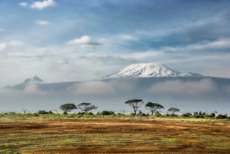
  • Mount Kilimanjaro, the tallest mountain in Africa is only 180 miles (292 km) from the Serengeti.

View of Kilimanjaro from Amboseli National Park, Kenya

View of Kilimanjaro from Amboseli National Park, Kenya


4)     Lençóis Maranhenses National Park, Brazil

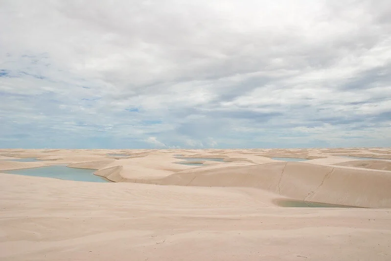
Located on Brazil’s northern coast, Lençóis Maranhenses is made up of a vast system of sand dunes.

However, unlike most coastal dune systems, which are often covered in vegetation, the Lençóis Maranhenses is rather unique.

  • Here, the sand of the dunes is exposed, producing an incredibly scenic landscape of white sand dunes that stretches for many miles into the horizon, interspersed with many turquoise-colored ponds of water.

  • This park is also known as the “Brazilian Sahara.”

  • Lençóis means ‘sheets’ in Portuguese

As one of the most coveted Brazilian destinations, the Lençóis Maranhenses National Park spreads over an area of 155,000 hectares, of which 90,000 are filled with dunes dotted with lagoons with translucent water (Image Source: Flickr).

As one of the most coveted Brazilian destinations, the Lençóis Maranhenses National Park spreads over an area of 155,000 hectares, of which 90,000 are filled with dunes dotted with lagoons with translucent water (Image Source: Flickr).


They are filled by monsoon rains during the wet season and are prevented from draining by an impermeable layer of rock beneath the surface. Aside from the dunes, two oases lie in the middle of the park, forming small pockets of vegetation surrounded by sand. Lençóis Maranhenses is also a magnet for wildlife, with 112 bird species and over 40 reptile species living here.

5)     Zion National Park, Utah, United States

Located in southwestern Utah, Zion National Park is a spectacular area of deep canyons, high peaks, and other geological formations.

The park is incredibly wild and includes a wide variety of habitats that cater to a very diverse ecosystem. Vast canyons eroding into the Markagunt Plateau cover much of the national park, lined with giant red- and gray-colored sandstone cliffs. Unique geological features can be found here, including The Subway – a tunnel-shaped slot canyon situated at the base of a much larger gorge.

Numerous natural arches have been carved into the sandstone, such as Kolob Arch, which hangs high above the canyon system of the same name. A multitude of waterfalls and canyon streams flow through the national park. A series of towering mountain peaks overlook the area, including North and South Guardian Angel, and Horse Mountain.


6)     Uluru-Kata Tjuta National Park, Australia

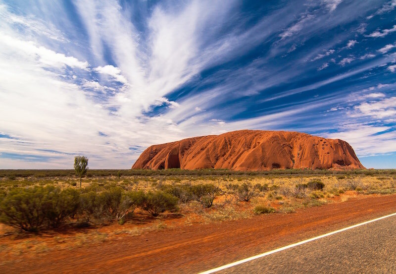
Surrounded by the vast wilderness of Australia’s Western Desert, the world-famous Uluru rock formation forms the centerpiece of this national park.

This giant red-colored sandstone formation is very unusual in that it is bordered by flat dryland plains on all sides, with steep slopes rising up from the ground on all sides. Deep gorges and inlets can be found around the slopes of Uluru, including the impressive Kantju Gorge.

The national park also includes a separate series of large domed rock formations called Kata Tjuta, many of which are separated by large gorges. Both Uluru and Kata Tjuta also have a great deal of cultural importance to the local Anangu people, who regard both rock formations as sacred.


7)     Torres del Paine, Chile

The Torres del Paine National Park is situated in the Patagonia region of southern Chile. It is an incredible landscape, most famous for its tower-like granite peaks of the Cordillera Paine mountain range, which reach majestically into the sky.

Vast glaciers run down from the mountains through deep valleys, with icebergs frequently calving into lakes filled with beautiful turquoise-colored glacial water.

Lu, part of team Pedal Chile at Parque Nacional Torres del Paine (Chile- South America)

Lu, part of team Pedal Chile at Parque Nacional Torres del Paine (Chile- South America)


A large lake named Lago Nordenskjold forms a boundary between the mountains to the north and a series of rocky grass-covered hills to the south – its southern shore provides the best views of the Cordillera Paine peaks. The Salto Grande waterfall is another highlight, with its bright blue-colored glacial water flowing over the wild landscape from one lake to another.

8)     Katmai National Park, Alaska, USA

Katmai National Park is located in southern Alaska, around 290 miles to the southwest of Anchorage. Katmai, the 6th least visited National Park and is larger than any park in the lower-48, is hard to get to. The only way into this park is by boat or floatplane, which departs from nearby King Salmon.

It has a wonderful landscape, with wild coniferous forests renowned for their brown bears, and large glacial lakes that are rich in salmon. The centerpiece of the national park is a giant snow-capped volcano named Mount Katmai, which last erupted in 1912, forming a vast caldera that was subsequently filled in by a lake that exists to this day.

The national park is also famous for its Valley of Ten Thousand Smokes – a deep layer of ash flow from the 1912 eruption. It was named a few years after the eruption when thousands of fumaroles venting steam from the ash were observed. Although the steam vents have since stopped, the ash-filled valley remains a rather unique landscape, a barren and flat stretch of land flanked by hills and forests.

The Bears of Brooks Falls

The coast of Katmai is home to 1,500-2,000 brown bears, which is the highest density of coastal brown bears in the world. This is because this region is also home to the largest salmon run in the world. Due to the sheer abundance of salmon, bears in the region tolerate close proximity to other bears and humans.

Here at Brooks River, you causally walk next to bears and oftentimes are within 10 feet (see picture above). The main reason visitors come to Katmai is to experience the unique interaction with bears and watch the river run pink with salmon.

Brown Bears at Brooks Falls, Katmai National Park (Image Source: Flickr)

Brown Bears at Brooks Falls, Katmai National Park (Image Source: Flickr)


9)     Zhangye Danxia National Park, Gansu Province, China

In the eastern foothills of the Qilian Mountains sits the Zhangye Danxia National Park.

  • It is renowned for its impressive and unusual hill markings, which are a series of vibrantly colored bands of rock – orange and reddish hues that contrast against gray and whiteish colors to create a beautiful and rather unique piece of scenery.

Since this is a badlands environment located in the middle of a vast, semi-arid part of China, there is a lack of soil or vegetation, leaving the bedrock exposed to the elements. Over many thousands of years, water erosion has formed steep valleys and gullies between each rocky hill, carving out an incredibly wild and rugged landscape.


10)  Calanques National Park, France

Located on the coast of southern France, just south of the city of Marseille, Calanques National Park is a superb blend of wild limestone cliffs and a quintessentially Mediterranean landscape.

The national park is made up of a scenic karstic environment, with craggy limestone hills overlooking the beautiful turquoise sea. The coastline is incredibly dramatic, with large rocky cliffs meandering their way around headlands, narrow inlets, and hidden beaches made of pristine white sand.

Parc national des Calanques (France)

Parc national des Calanques (France)


A range of large limestone hills lines the coast, covered by shrubs and wood of Mediterranean pine trees. The view from the hilltops is spectacular; the summit of Mont Puget provides amazing views of the coastline, and for many miles across the limestone plateau to the north.

 11) Hawai‘i Volcanoes National Park

This national park starts at the Pacific Ocean and extends all the way to 13,677 feet (4,169m) as it encompasses the summits of two of the world's most active volcanoes - Kīlauea and Mauna Loa.

Hawaii National Park opened in 1916, 43 years before Hawaii became the 50th U.S. state. Since there is nearly 14,000 feet of elevation change, plants and trees are widely varied, with climates ranging from desert to tropical rainforest.

Hikers explore the surface of the hardened lava lake that formed during the 1959 eruption at Kīlauea Iki crater (Image Source: Flickr)

  • There are at least 1,000 native species of flowering plants in Hawaii. Over 90% of these are endemic, meaning they are only found in Hawaii.

  • The park includes at least nine ecological zones; nearshore marine, seacoast, lowland, mid-elevation woodland, rain forest, upland forest, subalpine, alpine, and aeolian.

  • Numerous lava caves occur throughout the park. These include lava tubes, crater vent caves, fissure and rift zone caves, pressure ridge caves, tree mold caves, and sea caves among others.

  • Mauna Loa, at 13,677 feet (4,169m), is the world’s largest active volcano and has erupted nearly 40 times since 1832.

  • The two longest lava tubes in the world are located within the park.

Hōlei Sea Arch (Image Source: Flickr)

Hōlei Sea Arch (Image Source: Flickr)


valentina - bio pic.jpeg

Valentina is a guide for Pedal Chile and is our geology expert. Valentina has been in love with volcanoes ever since she first saw Villarrica glowing in her native country of Chile. Valentina was born and raised in La Patagonia, which probably explains her affinity for adventuring. When Valentina isn’t crushing some poor dude’s soul, you can find her shredding down Rucapillán. Favorite season: Austral Summer


Can you ride ebikes in national parks

ebike in a park.jpg

Can you ride eBikes in National Parks?

  • As of November 2nd, 2020, the National Park Service (NPS) authorized the use of electric bicycles that don’t exceed 750-watts throughout the United States National Park Service system on all roads and trails where traditional bicycles are also allowed.

    • Wilderness and backcountry areas PROHIBIT the use of ALL bicycles, including e-bikes.


Speed Limit Sign along Carriage Road in Acadia National Park

Speed Limit Sign along Carriage Road in Acadia National Park


E-bikes in U.S. National Parks & Regulations


In 2020, regulations were brought in by the U.S. National Park Service that permitted the use of electric bicycles – or ‘e-bikes’ – in all National Parks for the very first time.

Since electric bikes have grown in popularity over the last few years, with sales particularly skyrocketing during the COVID-19 pandemic, calls to allow for their use in National Parks have increased as well. The new regulations were designed to enhance the number of fun and recreational opportunities, allowing visitors to travel farther along bike trails than is permitted by pedal bikes, and to potentially reduce both the number of car trips made within National Parks and the space required for parking areas.

However, the legislation comes with some restrictions; ones which not only restrict the use of e-bikes to certain areas within National Parks but also define which specific types can be ridden.


Which Areas of a National Park Allow E-Bikes?


National Parks consist of many different road and trail types, as well as vast wilderness and back-country areas. Different road and trail types have different rules regarding whether e-bikes are permitted or not, and how they can be ridden. These rules are all listed below.

Paved Roads & Dirt Tracks

The use of electric bicycles is authorized on any National Park road that is already used by motorized vehicles that are not owned by the park itself. This includes paved park roads that are used by a wide range of motor vehicles, and dirt tracks that are designated for off-road vehicle use. Roads also permit people to use e-bike motors for as long as they can without having to pedal them, which is a bonus since some types of e-bikes can be propelled entirely by the motor, albeit for a limited time.

Traditional Biking Trails & Administrative Roads

E-bikes can be used on all National Park trails which are already used by traditional bicycles, including biking trails and administrative roads (ones that are only used by National Park-owned vehicles).

However, when using any of these trails/roads, it is prohibited to move an e-bike exclusively by its motor for an extended period of time. In other words, the operator must ensure that they keep pedaling when using them, as they are also used by traditional bikes. This compliments the new regulations, which are intended to allow the public to use e-bikes in a similar way to traditional bicycles, rather than as electric scooters (or even motorbikes), which are solely motorized vehicles.

Prohibited areas & E-bikes

Hiking Trails

As is the case with traditional bicycles, large areas within National Parks prohibit the use of eBikes, and hiking trails are one of them. Since hiking trails are designed to be used by walkers, often turning sharp corners and encountering rough terrain, they are not safe enough to be used by bikes of any kind.

The risk of potential collisions is significantly higher than on bicycle trails, meaning that there are large health and safety concerns with riding an e-bike on a hiking trail.

Also, hiking trails tend to go through areas that are more environmentally sensitive than a bicycle trail is. If you are caught riding an e-bike on hiking trails, you are subject to a fine.


Wilderness & Backcountry Areas

Wilderness and backcountry areas also prohibit the use of e-bikes – this is already the case with traditional pedal bikes. These parts often have a great amount of environmental importance – they form sensitive and diverse wildlife, plant, and tree habitats, and are often used as conservation areas that require environmental management and protection.

They are also used by walkers and tent campers, who enjoy the tranquility that these landscapes provide. Using a motorized vehicle in a wilderness area poses a threat to its environment, particularly by disrupting the tranquility of the area. As a result, e-bikes and traditional bikes are banned – by Federal statute – from all backcountry and wilderness areas, unless if you are using a trail that permits e-bikes that run through one.

This includes possessing a bicycle, e-bike, or any other form of motorized transport; in other words, it does not matter whether you are riding an e-bike or not, it is still against Federal law. Like with hiking trails, using an e-bike in wilderness areas is subject to a large fine, so make sure that you stay within permitted areas when riding an e-bike.


Classes of E-Bikes & regulations

Only certain types of e-bikes are allowed in National Parks according to the 2020 regulations.

They define an electronic bicycle as being a cycle that has an electric motor not exceeding 750 Watts. Although many e-bikes do not have a motor that is this powerful, some do exceed this and are therefore exempt from all National Parks.

The regulations also differentiate between different electronic bikes, by using a three-tier class system that groups e-bikes according to their top speed and whether throttle control is used.


The three-tier classes are important to note as National Park superintendents have the right to restrict certain e-bike classes from using specific roads or trails.

For example, a superintendent may decide that a specific trail can only be used by Class 1 e-bikes, or exclusively by Classes 1 and 2. This is to ensure that visitors similarly ride e-bikes to traditional bicycles, and pedal bikes rarely reach speeds exceeding 20mph.

In addition, the 2020 regulations allow a superintendent to prevent e-bikes from using any specific trail, even if traditional bikes are allowed on it. This ensures that public health and safety are maintained, and it is reasonable that the busier and more popular a trail is, the tougher the class restrictions will be.

Likely, class restrictions will not be applied to paved roads and dirt tracks that are open to public use, as these are already used by fast-traveling motor vehicles.


Valentina is a guide for Pedal Chile and is our geology expert. Valentina has been in love with volcanoes ever since she first saw Villarrica glowing in her native country of Chile. Valentina was born and raised in La Patagonia, which probably explains her affinity for adventuring. When Valentina isn’t crushing some poor dude’s soul, you can find her shredding down Rucapillán.


More articles from Pedal Chile

References & Sources

  1. “General Provisions; Electric Bicycles.” Federal Register, 2 Nov. 2020, www.federalregister.gov/d/2020-22129.

  2. ‌National Park Service. “Electric Bicycles (E-Bikes) in National Parks - Biking (U.S. National Park Service).” Www.nps.gov, www.nps.gov/subjects/biking/e-bikes.htm.

  3. Toll, Micah. “US National Parks Services Updates Regs, Allow E-Bikes up to 750W (with Exceptions).” Electrek, 3 Oct. 2020.

Is Puerto Rico Part of Latin America

The term “Latin America” means different things to different people. “Americans” understanding of this term is based mostly on stereotypes rather than facts. Many “Americans” imagine some poor “3rd World” improvised nation where the locals take siestas while wearing some oversized brimmed hat.

Even many analysts and “experts” erroneously define Latin America as encompassing all the countries south of the United States, including the English, French, and Dutch-speaking countries, plus the U.S. commonwealth of Puerto Rico.


Map of the traditional 20 countries of Latin America

Map of the traditional 20 countries of Latin America


Is Puerto Rico part of Latin America?

Puerto Rico is excluded from Latin America as it has never been independent (commonwealth of USA) and doesn’t share the key characteristics, such as post-independence timing, geopolitics, or liberated bureaucratic organization.


Traditional Latin America

Historically, Latin America was limited to 20 countries (see the above map):

  • The 10 Spanish and Portuguese speaking countries of South America

    • Argentina, Bolivia, Brazil, Chile, Colombia, Ecuador, Paraguay, Peru, Uruguay, Venezuela

  • The 6 Spanish speaking countries of Central America (Belize speaks English)

    • Costa Rica, El Salvador, Guatemala, Honduras, Panama, Nicaragua

  • Mexico

  • Cuba, Haiti, and the Dominican Republic in the Caribbean region

Shared History: Latin America

Geographers and geopolitical historians define Latin America as a group of nations that share 5 core traits:

  • Geographical

  • Timing of post-independence

  • Religion

  • Linguistic

  • Cultural


downtown Old San Juan - Puerto Rico

downtown Old San Juan - Puerto Rico


Geographical: Puerto Rico & Latin America

While the vast majority of Central and South America is considered to be part of Latin America - minus the three “Guianas” and Belize. The Caribbean region has traditionally not been associated with Latin America - minus Cuba and the island of Hispaniola (both the Dominican Republic and Haiti share this island).


Map of the Caribbean

carribean map.jpeg

The Caribbean has over 700 islands, 26 of which are independent nations - 30 are territories, including sovereign states, overseas departments, and dependencies - with Puerto Rico being one of these 30.

This region, which includes famous tropical islands, such as Aruba, the Bahamas, Barbados, the British and U.S. Virgin Islands, Cayman Islands, Grenada, Guadeloupe, and Montserrat has never been associated with Latin America. Geographically speaking, Puerto Rico is near the Dominican Republic, however, the Caribbean as a whole is not typically associated with Latin America.

Latin America & timing of post-independence

The standard 20 countries of Latin America all gained their independence within decades of each other:

  • 17 of these 20 countries gained their independence within 15 years of each other (Panama is more complex, but fits this timeline).

  • Haiti was the first to gain independence, only 6 years before the 15 year run of independence.

  • Puerto Rico, as of 2021, is still a U.S. territory and is NOT an independent nation.

    • Furthermore, Puerto Ricans, since 1917, have United State citizenship and are free to work and live on the mainland or travel to/from without restriction.


Capital building in San Juan - Puerto Rico

Capital building in San Juan - Puerto Rico


Puerto Rico & Oldest Colony

The title of the oldest colony in the world belongs to Puerto Rico. Christoper Columbus became the first European to land in PR in 1493, remaining under Spanish rule until becoming an unincorporated territory of the United States in 1898.

Historically, Puerto Rico was never considered part of Latin America because it was and remains to this day as part of the United States and is not an independent nation. Puerto Ricans by birth is granted U.S. citizenship and can freely travel and work in any of the 50 states.

The 20 original countries that makeup Latin America are all independent nations, therefore excluding Puerto Rico from the shared experiences of self-government.


Linguistic: Puerto Rico & Latin America

Since Puerto Rico was colonized by Spain in 1493, the Arawakan language of the native Taínos was replaced by Spanish. Even though Puerto Rico wasn’t to become a U.S. territory until 1898, Puerto Rico was trading and conducting business with the U.S. mainland since the 17th century.

In 1902, the Official Languages Act was instituted, which declared that in all governmental departments, courts, and public offices, English was to be regarded as co-official language along with Spanish.

Puerto Rico has two official languages:

  • English

  • Spanish

While Spanish is the majority language on the island, English is spoken as a second language by over 50% of the island's residents and is the dominant language in the professional workplace.


valentina - bio pic copy.jpg

Valentina is a guide for Pedal Chile and is our resident badass. Valentina was born and raised in La Patagonia, which probably explains her affinity for adventuring. When Valentina isn’t crushing some poor dude’s soul, you can find her shredding down Rucapillán. Favorite season: Austral Summer


Sources & References

  1. Pousada, Alicia & Alicia,. (1999). The singularly strange story of the English language in Puerto Rico. Milenio. vol. 3. pp.33-61.

  2. Suárez, Sandra L. “Does English Rule? Language Instruction and Economic Strategies in Singapore, Ireland, and Puerto Rico.” Comparative Politics, vol. 37, no. 4, 1 July 2005, p. 459, 10.2307/20072904.

Most Humid Place in the World

singapore.jpg

Both relative humidity and dew point are widely used indicators of the amount of moisture in the air.

  • Relative Humidity: The ratio of how much moisture the air is holding to how much moisture it could hold at a given temperature and indicated by a percentage.

  • Dew Point Temperature: The highest possible temperature that water vapor can condense to form water droplets known as dew.

relativity humidity graph.png
 

So what’s the difference between dew point and relative humidity?

The main difference is that relative humidity is dependent on temperature and is relative to that specific temp. The dew point is the temperature at which the air can no longer "hold" all of the water vapor, so some of the water vapor condenses into liquid water, usually in the form as fog, precipitation or dew.

Dew point: An accurate measurement of "humidity"

Relatively humidity is often misleading because warmer air can hold more moisture than cold air. For every 11°F increase in temperature, air’s ability to hold water doubles. For example, at 37°F with 100% relative humidity, the same exact amount of moisture in the air would equate to 20% relative humidity at 86°F. As for a dew point example:

  • 40°F outside with a dew point temperature of 40°F = 100% relative humidity

  • 75°F outside with a dew point temperature of 60°F = 60% relative humidity

Because dew point is a more reliable indicator of humidity, this articles uses it to answer three questions about humid places around the world:

  1. What is the most humid city in the world?

  2. What is the most humid country on Earth?

  3. What’s the most humid place?

(Image Source: Cizauskas)

(Image Source: Cizauskas)


1) Most Humid City in the World

Pearl-Qatar - an artificial island in Qatar

Pearl-Qatar - an artificial island in Qatar


There are several contenders for the most humid city in the world, based on which city across the globe has the highest dewpoint, and records incredibly high dewpoints all year round. Cities located almost directly on the Equator, have a constant wet season and intense heat, and are close to a large stretch of warm water are most likely contenders.

These include many cities in tropical Equatorial climates, such as:

  • Kuala Lumpur

  • Singapore

  • Jakarta

  • Manaus

However, other cities have recorded higher dew points, particularly around the Gulf of Aden and Persian Gulf regions, but only during the summer months.

Kuala Lumpur

Kuala Lumpur


Kuala Lumpur and Singapore record incredibly high dewpoints across the entire year. Average maximum dew points in Kuala Lumpur reach an impressive high of 83.3°F (28.5°C) during April, only falling to 80.2°F (26.8°C) during August.

However, Singapore is slightly more humid, with maximum average dewpoints of 83.8°F (28.8°C) recorded in April, and 81.9°F (27.7°C) recorded in August. This is not surprising as Kuala Lumpur and Singapore are located around 340 km (210 miles) and 140 km (90 miles) north of the Equator respectively, with an overhead Sun providing intense heat all year round. Both cities are also located close to a large body of water – Singapore borders the large Singapore Strait, whereas the centre of Kuala Lumpur is located around 40 km (25 miles) to the west of the Melacca Strait. The strong sunlight evaporates water from the warm surrounding seas, which in turn increases the moisture content of the air.

However, Manaus in Brazil also records comparatively high dewpoint values throughout the year. With a latitude of 3°S, and its location on the Amazon River in the middle of the Amazon Rainforest, it is no surprise that the average maximum dewpoint fluctuates between 81.3°F (27.4°C) in July and 83.7°F (28.7°C) in October.

Some cities around the world have seen higher dew point values than those already presented, but only during certain times of the year. Bangkok sees higher average maxima – of 85.3°F (29.6°C) in April and 83.7°F (28.7°C) in September, but dewpoints fall to below 78.8°F (26°C) during December and January.

Other high values are recorded seasonally, particularly around the Red Sea, Gulf of Aden and Persian Gulf regions. Despite being on the edge of a hyper-arid desert region, large evaporation rates and high sea surface temperatures combine to produce incredibly high humidity along the coastal regions between May and October.

Jakarta, the capital of the Republic of Indonesia

Jakarta, the capital of the Republic of Indonesia


The highest dewpoint recorded on Earth is in the city of Dhahran in Saudi Arabia, which experienced a dewpoint of 95°F (35°C) in 2003 – however, dewpoints above 90°F (32°C) are rare, and only occur in these regions during the summer months. For example, the city of Muscat is situated in Oman and overlooks the Persian Gulf.

Average maximum dewpoints above 84°F (29°C) in July and August regularly occur in Muscat, but these fall below 68°F (20°C) during December, January and February. Similar seasonal variations occur across the entire region.

(Hosseinzadeh Talaee et al.)

(Hosseinzadeh Talaee et al.)


2) Most Humid Country in the World

Palembang, Indonesia

Palembang, Indonesia


Identifying the most humid country in the world depends on numerous factors. Many countries have large differences in terrain, elevation, and climate.

Although the highest dewpoints in the world have been recorded on land bordering the Persian Gulf, Gulf of Aden, and the Red Sea, these are only limited to the coastal regions of the countries which border those seas.

  • For example, Saudi Arabia, Oman, and Yemen record dewpoints in excess of 86°F (30°C) along their coastal regions, but their large desert interiors located far from the surrounding seas record comparatively low dewpoint values.

This piece examines countries that have rather high dewpoints recorded across most of their terrain, and maintain the values during much (if not all) of the year.

The small country of Qatar is a strong contender for being the most humid country in the world. Despite its desert landscape and hyper-arid climate, it is a narrow peninsula located on the western side of the Persian Gulf, meaning that it is surrounded by water on its eastern, northern and western sides. Its maximum width of 90 km (55 miles) across means that much of the country is close to water. Its capital city, Doha, records dewpoints exceeding 81°F (27°C) between July and October peaking at 86°F (30°C) in September. However, there is a wide seasonal difference, with dewpoint values below 68°F (20°C) between December and March, meaning that the incredibly humid summer months are cancelled out by the winter months, which are significantly less humid.

Other contenders are likely to be an island, archipelago or coast-bordering nation that is close to the Equator, and has much of its terrain at or near sea level. Although many Equatorial countries that include large rainforests are rather humid, these often include many large upland areas that are cooler due to the lapse rate, making these countries less humid overall than other nations.

Singapore is both a city and a small country in its own right – since its average maximum dewpoint fluctuates between 81 - 84°F (27.7 - 28.895°C) throughout the year, it would be fair to declare this as the world’s most humid country overall.

But what about countries with a larger land mass? Both Malaysia and Indonesia have large lowland areas, despite the presence of large mountain ranges. Indonesia in particular straddles both sides of the Equator, and is made up of a vast archipelago that includes many islands surrounded by warm seas that often top 86°F (30°C). Inland areas of Indonesia also record high humidity levels, such as the city of Palembang around 75 km (45 miles) from the nearest sea. Here, dewpoint levels between 82 - 84°F (28°C and 29°C) are recorded throughout the year – this incredible humidity is felt across much of Indonesia all year round.


3) World’s most humid place

Persian Gulf of Qatar

Persian Gulf of Qatar


Although the coastal area alongside the Persian Gulf records incredibly high dewpoints, the coast of Eritrea along the Red Sea has the highest dewpoint in the world. This is due to a combination of incredibly high levels of strong and uninterrupted sunshine, as well as high water temperatures in the southern section of the Red Sea, which often exceed 90°F (32°C) during the hot months. For example, average maximum water temperatures alongside the port town of Assab in Eritrea peak above 86°F (30°C) between June and October. These factors produce incredibly high evaporation rates along the coastline, resulting in incredibly humid air along the Eritrean coast.

The air is moister along the south-western coast of the Red Sea than it is along the Persian Gulf. Like much of Arabia, the Persian Gulf is surrounded by a hyper-arid desert landscape, which limits the levels of humidity in the area to a small degree. However, although the terrain along the south-western side of the Red Sea is also rather dry, it is not as hyper-arid as the Middle East. For example, in Assab, at least one rainfall day is recorded per month. The wettest month is August, which sees an average of 29 millimetres of rain falling in the town, and around 80 millimetres of rainfall across an entire year.

The Blue Nile Falls is a waterfall on the Blue Nile river in Ethiopia. It is known as Tis Abay in Amharic, meaning "great smoke"

The Blue Nile Falls is a waterfall on the Blue Nile river in Ethiopia. It is known as Tis Abay in Amharic, meaning "great smoke"


The country of Ethiopia lies to the south of Eritrea – it is significantly less arid than the coastal regions around the Persian Gulf. This is in part due to its high altitude, with its large Ethiopian Highlands mountain range promoting a rather temperate climate, but also in part due to its latitude – it is far enough south to receive an annual monsoon season. The Ethiopian Highlands receive enough rain to be rather vegetated. The position of areas with relatively high rainfall rates (and therefore lower aridity) located significantly closer to the Eritrean coast means that the air will be more humid along the Red Sea than it will around the Persian Gulf.  


valentina - bio pic copy.jpg

 Valentina is a guide for Pedal Chile and is our resident badass. Valentina was born and raised in La Patagonia, which probably explains her affinity for adventuring. When Valentina isn’t crushing some poor dude’s soul, you can find her shredding down Rucapillán. Favorite season: Austral Summer


More articles from Pedal Chile

Sources & References

  1. Cizauskas, Thomas. “Dew Point.” Flickr, 9 Aug. 2017, www.flickr.com/photos/cizauskas/36373448982.

  2. Hosseinzadeh Talaee, P., et al. “Observed Changes in Relative Humidity and Dew Point Temperature in Coastal Regions of Iran.” Theoretical and Applied Climatology, vol. 110, no. 3, 29 Mar. 2012, pp. 385–393, 10.1007/s00704-012-0630-1.

  3. Raymond, Colin, et al. “The Emergence of Heat and Humidity Too Severe for Human Tolerance.” Science Advances, vol. 6, no. 19, May 2020, p. eaaw1838, 10.1126/sciadv.aaw1838.

  4. ‌US Department of Commerce, NOAA, National Weather Service. “Dew Point vs Humidity.” Weather.gov, 2019.

  5. Weather Atlas. “Āssab, Eritrea - Detailed Climate Information and Monthly Weather Forecast.” Weather Atlas, www.weather-atlas.com/en/eritrea/assab-climate. ‌

Is Puerto Rico More Humid than Florida?

Cueva Ventana, or "window cave," in Arecibo, Puerto Rico

Cueva Ventana, or "window cave," in Arecibo, Puerto Rico


Is Puerto Rico More Humid than Florida?

Florida, surrounded by the warm Gulf of Mexico and the Atlantic Ocean is the most humid state in the USA, according to their average dew point temperature. However, Puerto Rico, a U.S. territory in the tropical Caribbean is even more humid than Florida.

  • Key West City, the most humid city on mainland USA has an average relative humidity of 75.8%.

  • San Juan, the capital city of Puerto Rico has an average relative humidity of 78.3% which is 3.2% muggier than Key West, Florida.

    • (Many cities in Puerto Rico are more humid than San Juan).

Relative Humidty Compairson

PedalChile.Com

Puerto Rico & Humidity

Puerto Rico varies slightly in its levels of humidity due to two factors – the time of year and differences in altitude. Although different sources disagree slightly on the exact humidity percentage, they all agree that the average daily humidity is between 64 and 80%.

map of Puerto rico in Caribbean Sea.jpeg

For example, the daily relative humidity at San Juan is around 75%, although this figure varies between 71% in the month of March, and 78% in October. In addition, the city of Ponce, located on the island’s south coast, receives its highest relative humidity of 71% in November, which drops to 64% in March.

The capital city of Puerto Rico - San Juan

The capital city of Puerto Rico - San Juan


Therefore, although high relative humidity is a constant occurrence in Puerto Rico, it varies slightly, with lower levels in February, March, and April. As expected, the lower the temperatures are, the less intense the humidity is. Therefore, in areas with a higher elevation, the humidity feels marginally less – however, 70% humidity in around 80°F (27°C) still feels rather warm.

Florida & Humidity

A “storm” in Key West, Florida

A “storm” in Key West, Florida


The USA state of Florida is also well-known for its oppressive levels of humidity, which can reach large heights. Due to its location within a subtropical climate zone, as well as Florida, being surrounded by large areas of warm seawater on its eastern, southern, and western sides, different parts of the state experience a difference in the seasonal variation of its climate.


Northern Florida & Seasonal Variations

Northern Florida receives marked seasonal variations in its weather, with four main seasons occurring. These include a mild and short winter, and a rather long and hot summer which extends from May to October.

Humidity levels in this region look rather similar to that of San Juan’s – for example, in the city of Jacksonville, the relative humidity hovers between 69 and 76%, peaking at around the mid-70s from July to September, and falling to its lowest value during the spring months.

However, as is the case throughout much of northern Florida, annual temperature variations are relatively large in Jacksonville – maxima during the winter months are typically below 70°F (21°C), but typically reach 90°F (32°C) in June, July, and August.

Therefore, although humidity levels are near-constant, it is only uncomfortably noticeable during the summer and early fall months, whereas during winter and the early spring, it is not an issue.

Aerial view of Miami, Florida

Aerial view of Miami, Florida


Southern Florida & Humidity

Similar levels of humidity are found throughout much of Florida. The city of Miami is located on the state’s south-eastern coast – here, relative humidity levels are generally rather high, peaking at 75% in December, and dropping to 70% in March.

However, the seasonal temperature variation is more limited in southern Florida than it is in northern areas of the state, with hot and humid weather a more common occurrence the further south one travels. In Miami, maximum temperatures typically peak at 73°F (23°C) in January, and max out at above 85°F (29°C) in July, August, and September.


7 Mile Bridge - Key West (Florida, USA)

7 Mile Bridge - Key West (Florida, USA)


Therefore, although relative humidity levels around Miami, Fort Myers, and the Everglades are similar to that of northern Florida, uncomfortable levels of humidity are experienced for more of the year in southern parts of the state than it is around Jacksonville, Tallahassee, and their surrounding areas.

Conclusion: Puerto Rico = More humid than florida

The humidity in both Puerto Rico and Florida is similar, with both areas commonly experiencing levels of relative humidity between 64 and 78%. If anything, data from Puerto Rico suggests a slightly larger range of humidity levels than Florida, although this may be due to southern Puerto Rico experiencing lower amounts of moist air than the north coast does.

However, the level of humidity ‘felt’ in both regions varies between the regions – this is influenced by seasonal variations in climate, which occur significantly more in Florida than in Puerto Rico. Whereas particularly northern parts of Florida may not notice the humidity much in the winter months, it is a constant occurrence in Puerto Rico.


valentina - bio pic copy.jpg

Valentina is a guide for Pedal Chile and is our geology expert. Valentina has been in love with volcanoes ever since she first saw Villarrica glowing in her native country of Chile. Valentina was born and raised in La Patagonia, which probably explains her affinity for adventuring. When Valentina isn’t crushing some poor dude’s soul, you can find her shredding down Rucapillán.


Sources & References for “Is Puerto Rico More Humid Than Florida?”

  1. climate-Data.org. “San Juan Climate: Average Temperature, Weather by Month, San Juan Water Temperature - Climate-Data.org.” En.climate-Data.org, en.climate-data.org/north-america/united-states-of-america/puerto-rico/san-juan-986/. ‌

  2. Florida Climate Center. “Humidity - Florida Climate Center.” Climatecenter.fsu.edu, climatecenter.fsu.edu/topics/humidity.

  3. “Miami, FL - Detailed Climate Information and Monthly Weather Forecast.” Weather Atlas, www.weather-us.com/en/florida-usa/miami-climate#humidity_relative.

  4. “Orlando, FL - Detailed Climate Information and Monthly Weather Forecast.” Weather Atlas, www.weather-us.com/en/florida-usa/orlando-climate#humidity_relative.

  5. ‌Weather Atlas. “Jacksonville, FL - Detailed Climate Information and Monthly Weather Forecast.” Weather Atlas, www.weather-us.com/en/florida-usa/jacksonville-climate#humidity_relative.

  6. ‌Weather Atlas. “Key West, FL - Detailed Climate Information and Monthly Weather Forecast.” Weather Atlas, www.weather-us.com/en/florida-usa/key-west-climate#humidity_relative.

Do They Speak English in Puerto Rico

puerto rico info graphic for languages.jpeg

Due to Puerto Rico’s status as an American commonwealth, located in the tropical Caribbean, it is often referred to as a bilingual territory.

  • Both English and Spanish are spoken and both are official languages.


However, Spanish is undoubtedly the most widely used of the two and is the native language for the majority of the island’s population. Although English is used by about 50% of the island’s residents it’s only spoken in 5% of households.


English Speakers Within Puerto Rico

The above English-speaking map is from a 2010 study that researched “the role of English speakers in the linguistic ecosystem of Puerto Rico.” This data is from the 2000 U.S. Census. While this data has changed over the last 21 years, the actual concentration of English speakers is still an accurate representation (Image Source: Pousada).

The above English-speaking map is from a 2010 study that researched “the role of English speakers in the linguistic ecosystem of Puerto Rico.” This data is from the 2000 U.S. Census. While this data has changed over the last 21 years, the actual concentration of English speakers is still an accurate representation (Image Source: Pousada).


Do they speak English in Puerto Rico?

According to U.S Census data and a 2017 Puerto Rican poll, approximately 50% of Puerto Ricans living on the island, either is fluent in English or have a basic level:

  • 50% of Puerto Ricans speak English daily, but ONLY 5% speak it at home

  • 1/5 of Puerto Rico’s residents are either native English speakers or fully fluent

While many Puerto Ricans are bilingual, especially in academia, international business, and tourism, English is the second language for the majority of the island residents. Even though 1 out of 2 Puerto Ricans speak conversational English or better, the vast majority of islanders only speak English in business settings or while watching American movies or programs.


Municipalities & percentage of English Speakers

PedalChile.Com (info sourced from Pousada 2010)

Puerto Rico & English Speakers

Information from the above graph and map highlights the fact that the majority of bilingual Puerto Ricans are concentrated in the San Juan metro area and the tourist hotspots along the coast.

This makes sense, as many of the social, business, and customer interactions are conducted primarily in English in these locations. In these areas, the vast majority of workers and residents speak at least a basic level of English.


San Juan metropolitan area

San Juan at night

San Juan at night


In the mountainous interior, outside of San Juan metro, and away from the tourist areas, the number of Puerto Ricans that speak English is a rarity. There are remote areas where less than 1% of residents understand English at even an elementary proficiency.

English as a first Language & Puerto Rico

The use of English as a primary language exists in many small enclaves on the archipelago. Due to unlimited travel between the USA and Puerto Rico, a small number of Americans born in the contiguous states have moved to the islands for various reasons, including to fulfill U.S. military duties, to accept business opportunities, or to pursue the ‘Caribbean life’.

However, they almost exclusively settle in specific neighborhoods within Puerto Rico – ones that are significantly more ‘Americanized’ than the rest of the territory. These are fairly self-contained communities, with amenities that are designed for Americans. Children are often taught in private schools that teach primarily in English.

Thus, in areas where English is only spoken, many speakers tend to be rather ‘fenced off’ from the rest of the island, with the widespread use of the language not being found in many places outside.


Culebra

Flamenco Beach on the Puerto Rican island of Culebra has the most English speakers in Puerto Rico. This island is actually closer to the British Virgin Islands than to the main island and is a former U.S. Naval base. Now, over 20% of this island is a National Wildlife Refuge and is home to the best beaches in Puerto Rico.

Flamenco Beach on the Puerto Rican island of Culebra has the most English speakers in Puerto Rico. This island is actually closer to the British Virgin Islands than to the main island and is a former U.S. Naval base. Now, over 20% of this island is a National Wildlife Refuge and is home to the best beaches in Puerto Rico.


Circular Migration

Puerto Ricans are U.S. citizens. This allows island residents unlimited travel between Puerto Rico and the contiguous states. It’s very common for Puerto Ricans to live on mainland U.S. and return later to the island – these are often people who relocated to the USA for various reasons, most likely for better work opportunities and have since returned.

Puerto rico world map and usa.jpeg

While in the USA, many spoke and used English daily, thereby learning it to a fluent or near-fluent level. Due to their interaction with both societies, they are significantly more bilingual than those who spend their entire life within Puerto Rico, and American migrants to the island. However, they are far more likely to use Spanish when communicating with other Puerto Ricans.


valentina - bio pic copy.jpg

Valentina is a guide for Pedal Chile and is our resident badass. Valentina was born and raised in La Patagonia, which probably explains her affinity for adventuring. When Valentina isn’t crushing some poor dude’s soul, you can find her shredding down Rucapillán. Favorite season: Austral Summer.


‌Sources & References for “Do they speak English in Puerto Rico?”

  1. “English Language in Puerto Rico.” Wikipedia, 3 May 2021, en.wikipedia.org/wiki/English_language_in_Puerto_Rico.

  2. ‌NW, 1615 L. St, et al. “Puerto Rican Population Declines on Island, Grows on U.S. Mainland.” Pew Research Center’s Hispanic Trends Project, 11 Aug. 2014, www.pewresearch.org/hispanic/2014/08/11/puerto-rican-population-declines-on-island-grows-on-u-s-mainland/.

  3. Pousada, Alicia. ENGLISH-SPEAKING ENCLAVES in PUERTO RICO 1. , 19 Mar. 2010.

  4. “QuickFacts: Puerto Rico.” Census Bureau QuickFacts, United States Census Bureau, 2018, www.census.gov/quickfacts/pr.

  5. “Speaking English in Puerto Rico | Puerto Rico 51st.” Puerto Rico 51st, www.pr51st.com/speaking-english-in-puerto-rico/.

The World's Hottest Cities - Top 12


This list of the World’s Hottest Cities has been formulated from each city's daily mean temperature. These temps are averages of the daily high and low over the entire year. The actual daytime temperatures, depending on the month, will be 4 to 18°F (2 to 10°C) higher than the daily average.

I have listed the 12 hottest cities in the World in reverse order. For a quick summary, reference the map above.


12) Port Sudan City, Sudan 83.12°F/28.4°C

Port Sudan -Sudan (Image Source)

Port Sudan -Sudan (Image Source)


Port Sudan is a city located on the coast of the Red Sea, on the eastern side of the country of Sudan. Its latitude primarily explains why Port Sudan receives incredibly high temperatures – it is located at around 19°N, meaning that the Sun is high in the sky all year round.

The city is situated in a dry, desert climate, allowing temperatures to reach much higher maxima than they would in a humid and wet setting. Port Sudan is also close to sea level, meaning that air temperatures do not decrease due to the lapse rate – it is also nestled around 12 miles (20 km) to the east of the Red Sea Hills mountain range, sheltering the city from easterly winds at times, preventing ventilation.

  • Hottest Month: August, with an average high-temperature of 40.2°C (104.4°F)

  • Coldest Month: January, with an average high-temperature of 26.8°C (80.2°F)

  • Humidity: The average annual relative humidity is 63.0%

The Meroe Pyramids are located in the North-East of Sudan near the banks of the Nile (Image Source: Flickr)

The Meroe Pyramids are located in the North-East of Sudan near the banks of the Nile (Image Source: Flickr)


11) Manila, Philippines 83.12°F/28.4°C

Manila, Philippines

Manila, Philippines


The Philippines is a tropical country with only two types of weather: Scorching hot or soaking wet and humid. Of the world’s top 12 hottest cities, Manila has the highest humidity and is even slightly muggier than Bangkok.

  • Hottest Month: April, with an average high-temperature of 33.5°C (92.3°F)

  • Coldest Month: January, with an average high-temperature of 29.6°C (85.3°F)

  • Humidity: The average annual relative humidity is 74.0% (highest on this list)

10) Bangkok, Thailand 83.6°F/28.6°C

Image Sources: Wikimedia Commons & Flickr


The tropical city of Bangkok is located less than 1,000 miles (1,609 km) away from the equator but due to the urban heat island (UHI) phenomenon and the humidity, Bangkok feels even hotter than the thermostat, which is already scorching hot and humid.

The metropolis of Bangkok

The metropolis of Bangkok


  • Hottest Month: April, with an average high-temperature of 35.4°C (95.7°F)

  • Coldest Month: December, with an average high-temperature of 31.7°C (89.1°F)

  • Humidity: The average annual relative humidity is 73% (2nd highest)

  • Population: 10.72 million residents (plus another 1-million tourists, pre-COVID)

9) Ouahigouya, Burkina Faso 83.5°F/28.6°C

(Image Source)

(Image Source)


Ouahigouya is a city located in northern Burkina Faso, the hottest country on Earth. Its incredible heat is due to its low latitude, a fairly low altitude (~ 985 ft/300 m), and its proximity to the Sahara Desert, the border of which is just to the north of the city.

Its location in the northern Sahel region means that the dry season has a longer length than more Equatorial places, meaning that incredibly high temperatures occur around much of the year.

Nazeing national park in Burkina Faso

Nazeing national park in Burkina Faso


However, the short wet season is also rather hot and humid, increasing the minimum temperatures during this period. It is also a long distance from the nearest sea or a large body of water, resulting in a lack of any refreshing sea breezes.

  • Hottest Month: April, with an average daytime high-temperature of 106.5°F | 41.4°C

  • Coldest Month: January is the coldest month, with an average daytime high-temperature of 91.8°F | 33.2°C

  • Humidity: The annual average relative humidity of 49%

8) Aden, Yemen 84.4°F/29.1°C

Image Sources: Both from (left) Wikimedia Commons & (right) Wikimedia Commons


Aden is a port city that is situated in the southwest of Yemen. Located on the southern edge of the Arabian Desert, it receives very little precipitation, with sunny days and clear blue skies occurring pretty much all year round, with very little interruption from cloud cover. 

This causes the temperatures – particularly between May and September – to reach a rather high maxima. Aden is also located at around 12°N, meaning that the Sun is always high in the sky. Since it is a port city, Aden also has a low altitude, with the lapse rate allowing for higher temperatures than it would for areas located at higher altitudes. 

Aden, Yemen

Aden, Yemen


  • Hottest Month: June, with an average high-temperature of 36.6°C (97.9°F)

  • Coldest Month: January, with an average high-temperature of 28.5°C (83.3°F)

  • Humidity: The average annual relative humidity is 70%

7) Niamey, Niger 84.7°F/29.3°C

(Hungerford)

(Hungerford)


Niger is the 18th hottest nation on Earth, and is famously known as the “Frying Pan of the World.” Referred to as one of the world’s hottest cities, Niamey is located on the western side of the African country of Niger.

It owes its heat partly to its low latitude, with an overhead Sun allowing the city to experience its full energy. Its location in the northern Sahel region also allows the city to receive a long dry season between October and May, during which practically no rain falls, allowing for incredibly hot temperatures to occur.

The wet season is rather short and produces rather hot and humid weather. Niamey is located within the Iullemmeden Basin, meaning that it has a comparatively low altitude than other parts of the Sahel region.

The skyline in Niamey, Niger

The skyline in Niamey, Niger


  • Hottest Month: April, with an average maximum temperature of 105°F | 41°C

  • Coldest Month: January, with an average maximum temperature of 90°F | 32°C

  • Humidity: The average annual relative humidity is 42%

  • Population: 1.027 million

6) Lodwar, Kenya 84.7°F/29.3°C

Lodwar, located in north-western Kenya (Image Source: Wikimedia Commons)

Lodwar, located in north-western Kenya (Image Source: Wikimedia Commons)


Lodwar is a large town located in north-western Kenya. It has an incredibly hot and dry semi-arid climate all year round, with a brief wet season from late March to early May.

Its 3°N latitude means that the Sun is almost directly above throughout the year, contributing to the constantly high daily maxima recorded here. The dry savannah-type landscape around the town means that evaporation is very low, preventing cloud formation and allowing for high amounts of sunshine, which in turn increases the maximum temperatures even further.

Furthermore, Lodwar is located within a large basin – the Great Rift Valley – meaning that the town is significantly hotter than surrounding areas that have a higher elevation.

Lodwar, Kenya (Image Source: Wikimedia Commons)

Lodwar, Kenya (Image Source: Wikimedia Commons)


  • Hottest Month: February, with an average high-temperature of 36°C (96.8°F)

  • Coldest Month: July, With an average high-temperature of 32.1°C (89.8°F)

  • Humidity: The average annual relative humidity is 44%

5) Abéché, Chad 84.9°F/29.4°C

Abéché is located in the eastern part of the Sahelian zone (orange-yellow)

Abéché is located in the eastern part of the Sahelian zone (orange-yellow)


Resting within sub-Saharan Africa, it is no surprise that Abéché receives very high temperatures. This is largely due to a lack of evaporation from the vast dry savannah that surrounds the city, preventing the formation of clouds, and allowing the Sun to shine on most days.

During its short wet season, maximum temperatures are reduced, but it remains rather hot and humid. Its low latitude also allows the sun to appear high in the sky around the year, albeit particularly from March to September. Its incredible distance from the nearest sea, or body of water, also means that there is a complete absence of cooling sea breezes.

9 of the 10 hottest cities in the World are in this region, with the majority being located in or near the Sahel region of Africa.

9 of the 10 hottest cities in the World are in this region, with the majority being located in or near the Sahel region of Africa.


  • Hottest Month: April is the warmest month, with an average high-temperature of 40.2°C (104.4°F)

  • Coldest Month: August, with an average high-temperature of 32°C (89.6°F)

  • Humidity: The average annual relative humidity is 34.3%

4) Khartoum, Sudan 85.8°F/29.9°C

Nile river in Khartoum, Sudan

Nile river in Khartoum, Sudan


Surrounded by the vast Sahara Desert on its northern and western sides, and with the semi-arid Sahel region to its south, Khartoum is the world’s 4th hottest city, experiencing exceptionally high temperatures.

Despite being at the confluence of both the White and Blue Nile rivers, the landscape around the city is incredibly arid – this limits evaporation, preventing cloud formation, and subsequently allowing scorching sunshine for much of the year.

Khartoum, Sudan map climate.jpeg

Khartoum also lies within a basin (at an altitude of around 1,150 ft | 350 m above sea level), which allows for hotter temperatures to occur in this region than they would in surrounding areas with a higher altitude.

  • Hottest Month: May, with an average high-temperature of 41.9°C (107.4°F)

  • Coldest Month: January, with an average high-temperature of 30.7°C (87.3°F)

  • Humidity: The average annual relative humidity is 28.8%

3) Djibouti City, Djibouti 85.8°F/29.9°C

Djibouti City

Djibouti City


Djibouti City is a port that is located on the eastern side of the country of Djibouti, on the coast of the Gulf of Aden. It is one of the world’s hottest urban areas – this is mainly due to its adjacent desert landscape.

Djibouti port map.jpeg

Near-constant high pressure over the region allows the sun to shine almost continuously, allowing for a lack of cloud development, and thus for very high maxima to be recorded. Djibouti City’s sea level altitude further increases the ability for high temperatures – by contrast, mountain areas within the interior of Djibouti record slightly lower average temperatures, sometimes by more than 6°C.

  • Hottest Month: July, with an average high-temperature of 37.9°C (100.2°F)

  • Coldest Month: January, with an average high-temperature of 26.3°C (79.3°F)

  • Humidity: The average annual relative humidity 61.0%

2) Bosaso, Somalia 86°F/30.0°c

map of Somalia.jpeg

The port city of Bosaso is situated on the northern coast of Somalia, overlooking the Gulf of Aden. Located very close to the Equator, the city is incredibly dry and sunny all year round, with the lack of a defined wet season.

Therefore, since cloud cover is rare, daily maximum temperatures are always rather high – particularly between May and September, when the sun is more or less directly overhead.

The Gulf of Aden is also rather warm all year round (yearly average 83°F/28°C), preventing temperatures in the city from dropping as much overnight as they would in inland desert areas. Bosaso’s low altitude also allows high temperatures to occur here.


Bosaso, Somalia (Image Source: Wikimedia Commons)

Bosaso, Somalia (Image Source: Wikimedia Commons)


  • Hottest Month: June and July, with an average high-temperature of 41°C (105.8°F)

  • Coldest Month: January, with an average high-temperature of 29°C (84.2°F)

  • Humidity: The average annual relative humidity 62.0%

1) Assab, Eritrea 86.9°F/30.5° c

Image Source: Wikimedia Commons

Image Source: Wikimedia Commons


Assab is a port city that is located in southern Eritrea, on the coast of the southern Red Sea. Like many cities that are within desert climate zones, near-constant daily sunshine allows temperatures to reach incredible maxima during the day, aided by the lack of cloud development.

Asmara - the capital city and largest city in Eritrea  (about 485 miles away from Assab)

Asmara - the capital city and largest city in Eritrea (about 485 miles away from Assab)


Due to its latitude (13°N), not only does this city experience near-constant high pressure all year round, but it is also under the influence of the Sun’s strong rays. Like with the Gulf of Aden, the Red Sea is also rather warm, preventing temperatures from decreasing overnight as much as they would inland. The low altitude of the region also facilities for incredibly high temperatures. 

  • Hottest Month: July, with an average high-temperature of 41.2°C (106.2°F)

  • Coldest Month: January, with an average high-temperature of 31.3°C (88.3°F)

  • Humidity: The average annual relative humidity is 58%

  • Average dewpoint in June: 84°F (29.3°C) which is the highest monthly dewpoint for any city in the world. So in addition to being hot, this city is also insanely humid during June.


valentina - bio pic copy.jpg

Valentina is a guide for Pedal Chile and is our geology expert. Valentina has been in love with geology ever since she first saw Villarrica glowing in her native country of Chile. Valentina was born and raised in La Patagonia, which probably explains her affinity for adventuring. Favorite season: Austral Summer


Related articles from Pedal Chile


Sources & References for “World’s Hottest Cities”

  1. “AB.” Wikipedia, Wikimedia Foundation, 26 Feb. 2019, en.wikipedia.org/wiki/Ab.

  2. Babikir, Mahamat Hassane, et al. “Estimation of Direct Solar Radiation of Chad.” Energy and Power Engineering, vol. 10, no. 5, 9 May 2018, pp. 212–225, www.scirp.org/journal/paperinformation.aspx?paperid=84809, 10.4236/epe.2018.105015.

  3. ‌“Bosaso.” Wikipedia, 10 Apr. 2021, en.wikipedia.org/wiki/Bosaso.

  4. Carlowicz, Michael. “Where Is the Hottest Place on Earth?” Earthobservatory.nasa.gov, 5 Apr. 2012, earthobservatory.nasa.gov/features/HottestSpot.(Image Source: opening photo adapted from this map)

  5. “Darwin.” Wikipedia, 16 Dec. 2019, en.wikipedia.org/wiki/Darwin.

  6. “Djibouti (City).” Wikipedia, Wikimedia Foundation, 24 Jan. 2019, en.wikipedia.org/wiki/Djibouti_(city).

  7. “Gulf of Aden.” Wikipedia, Wikimedia Foundation, 8 Oct. 2019, en.wikipedia.org/wiki/Gulf_of_Aden.

  8. Hungerford, Hilary B. “Water, Cities, and Bodies: A Relational Understanding of Niamey, Niger.” Kuscholarworks.ku.edu, 31 May 2012, kuscholarworks.ku.edu/handle/1808/10642.

  9. “Khartoum.” Wikipedia, Wikimedia Foundation, 21 Sept. 2019, en.wikipedia.org/wiki/Khartoum.

  10. “List of Cities by Average Temperature.” Wikipedia, 10 June 2020, en.wikipedia.org/wiki/List_of_cities_by_average_temperature.

  11. “Lodwar.” Wikipedia, 18 Mar. 2021, en.wikipedia.org/wiki/Lodwar.

  12. “Manila.” Wikipedia, Wikimedia Foundation, 8 Sept. 2019, en.wikipedia.org/wiki/Manila.

  13. “Ouahigouya.” Wikipedia, 18 Feb. 2021, en.wikipedia.org/wiki/Ouahigouya.

  14. Wikipedia. “Aden.” Wikipedia, 27 Apr. 2021, en.wikipedia.org/wiki/Aden.

  15. Wikipedia Contributors. “Assab.” Wikipedia, Wikimedia Foundation, 7 Mar. 2019, en.wikipedia.org/wiki/Assab.

  16. Wikipedia Contributors. “Bangkok.” Wikipedia, Wikimedia Foundation, 13 Feb. 2019, en.wikipedia.org/wiki/Bangkok.

Can I Use WD-40 On My Guns?

wd40 gun.jpg

 
There are hundreds of gun cleaning products on the market, and they all work in some manner or fashion. Do not use water and do not use WD-40 to clean guns.
— From the book "Pheasant Hunting Tactics"


Can I use WD-40 on my guns?

  • WD-40 is NOT a protectant, cleaner, nor lubricant and should NOT be used on firearms.


There are three reasons we use gun oil:

  1. Clean

  2. Lubricate

  3. Protect

Below, I will discuss how WD-40 performs in each of those roles.

Cleaner

Since WD-40 is primarily a solvent it seems to make sense that it would be ideal for cleaning guns. However, cleaning your guns with WD40 is NOT advisable.

Solvents, such as WD40, don’t remove any gunk or slime.

  • Solvents dissolve gunk, which then moves the dissolved goo to another area of your gun that you cannot see.

  • Using an aerosol solvent simply “shoots” all the gunk into tiny crevices in your firearm, making them even harder to clean and can lead to “gumming” up.

Lubricant

WD-40 is a solvent and NOT a lubricant. Because it evaporates so quickly WD-40 does not function well as a lubricant in guns. Between the time you spray it on the chamber or slide and the time you load your rounds and start firing, it would almost certainly be evaporated, leaving your gun bone dry.

  • MYTH: WD-40 is a lubricant.

  • FACT: “WD” stand for “Water Displacement” and is primarily a solvent.

Protectant

As stated above, WD-40 evaporates so quickly, that it won’t protect your gun for very long. Before storing your firearms in a gun safe for long periods, an actual oil should be used (oil doesn’t evaporate and will protect your firearm from rusts).

  • WD-40 is mostly comprised of mineral spirits. Once these mineral spirits evaporate, your gun will be left with unprotected metal and your firearm will start to rust.

WD40 & exceptions

There are only two situations where WD-40 can/should be used:

  1. In an emergency

    • Such as dropping your gun in a lake or puddle.

  2. When disassembling your gun

    • It’s okay to use WD-40 for a deep cleaning when you disassemble your firearm. Especially if your gun contains moisture. “WD” will displace the water and keep it from rusting so long as you thoroughly clean after using WD40 and apply oil before storing your firearm.


valentina - bio pic copy.jpg

Valentina is a guide for Pedal Chile and is our resident badass. Valentina was born and raised on a sheep farm in La Patagonia, which explains her affinity for adventuring and guns. Hobbies: Bookworm, geographer, cycling, mtb, and blowing sh*t up. Favorite Season: Austral summer.


More articles from Pedal Chile

Sources & References for “Can I Use WD40 On My Gun?”

  1. Gaeddert, Dan. “Question: Can I Use WD40 to Clean Guns? [Ill-Advised].” Best Reloading Press, 9 Apr. 2018, reloadingpresso.com/can-use-wd40-clean-guns/.

  2. GunTortureTests. “Gun Myths Debunked Ep. 2: WD-40.” Www.youtube.com, 10 Sept. 2014, www.youtube.com/watch?v=7zxliQcKYkk.

  3. Keleher, Mike. Pheasant Hunting Tactics. United States, Mike-Keleher-Black Rifle Ranch, 2013.

  4. Safety Data Sheet California CARB Compliant 1 -Identification Product Name: WD-40 Multi-Use Product Aerosol Product Use: Lubricant, Penetrant, Drives out Moisture, Removes and Protects Surfaces from Corrosion Restrictions on Use: None Identified SDS. , 2019.

  5. Thornton, Lee. You’re Doing It Wrong! : How to Improve Your Life by Fixing Everyday Tasks You (and Everyone Else) Are Totally Screwing Up. Avon, Mass., Adams Media, 2012.

  6. Wired Staff. “What’s inside WD-40? Superlube’s Secret Sauce.” Wired, 20 Apr. 2009, www.wired.com/2009/04/st-whatsinside-6/.

Hottest Temperature on Earth

Dasht-e Lut Desert in Iran (Image Source: Wikimedia Commons)

Dasht-e Lut Desert in Iran (Image Source: Wikimedia Commons)


The World Meteorological Organization has approximately 11,119 weather stations on Earth. While this might seem like a lot, it equates to only 1 weather station for every ~56 million sq. miles (144.68 million sq. km) of Earth’s land surface. The hot deserts, such as the Sahara, the Gobi, the Sonoran, the Pilbara, the Lut, and the Taklamakan Desert - are so climatically harsh and remote that it’s impossible for routine measurements, let alone installation and regular maintenance. As a result, the majority of Earth’s true hot spots are not actually directly measured via ground-based instruments (i.e. thermometers).

Contrary to popular misconception, Death Valley’s Furnace Creek or the small town of El Azizia in Libya is NOT the hottest place on Earth. While both of these places are hot by normal living standards, they are not even serious contenders.

Fortunately for us, NASA has operated the Moderate Resolution Imaging Spectroradiometer (MODIS) which detects thermal radiance emitted by the land surface. These satellites view the entire Earth’s surface and provide temperatures to the most isolated hot spots on our Planet.


What is the hottest temperature recorded on Earth?

According to NASA, the hottest temperature on earth, 159.3°F (70.7°C) was recorded in the lowest area of the Lut Desert (Dasht-e-Lut), Iran, in 2005.

  • For comparison, Death Valley’s highest recorded temperature was 134°F / 56.7°C in 1913, which is 22% cooler

hottest places on earth.jpg
 

3 Hottest Temperatures recorded on Earth

  1. Lut Desert, Iran: 159.3°F (70.7°C)

  2. Australia’s Badlands: 157°F (69.3°C)

  3. Turpan Basin, China: 152°F (66.8°C)


Lut Desert - Iran

The Lut Desert, Iran (Image Source: Alavipanah et al. 2007)

The Lut Desert, Iran (Image Source: Alavipanah et al. 2007)


The deserts of Iran are often considered to be one of the hottest and driest desert regions on Earth. The Lut is one of Iran’s largest desert basins, consisting mainly of a largely dry and desolate plateau covered in salt flats.

  • In 2004, a Land Surface Temperature (LST) of 154°F (68°C) was recorded in the Lut Desert, only to be beaten in 2005 with an even higher temp of 159.3°F (70.7°C).

    • This remains to this day as the world’s hottest temperature ever recorded

Iran (Image Source: Wikimedia Commons)

Iran (Image Source: Wikimedia Commons)

The fact that the Lut Desert also recorded the highest temperature on earth for each year between 2004 to 2007, and in 2009, shows that this region is likely to be the hottest region on Earth. Although many of the world’s deserts are incredibly hot, the hottest temperatures tend to be recorded in low-lying deserts with a great deal of dry, rocky and dark-colored land – the Lut Desert fits this rather well, with dark pebbles, and closely-packed rock fragments being rather frequent features on the desert’s plateau.

Vegetation cover is also a large factor – although deserts generally contain low amounts of plant and shrub cover, desert areas range from slightly vegetated through to being completely barren. The hottest desert temperatures are recorded in areas with no vegetation and irrigation in the vicinity. This is certainly the case for the areas of the Lut Desert where the highest temperature readings were recorded, with no vegetation at all in these parts of the desert.


The Lut Desert

The Lut Desert, widely referred to as Dasht-e Lut (Persian: دشت لوت‎, "Emptiness Plain"), is a large salt desert located in the provinces of Kerman and Sistan and Baluchestan, Iran. It is the world's 27th-largest desert, and was inscribed on UNESCO'…

The Lut Desert, widely referred to as Dasht-e Lut (Persian: دشت لوت‎, "Emptiness Plain"), is a large salt desert located in the provinces of Kerman and Sistan and Baluchestan, Iran. It is the world's 27th-largest desert, and was inscribed on UNESCO's World Heritage List on July 17, 2016 (Image & Quote: Flickr).


Australia’s Badlands - Queensland

Image Source: (Wikimedia Commons)

Image Source: (Wikimedia Commons)

In 2003, the hottest temperature recorded on Earth was 157°F (69.3°C), in a barren area of desert shrublands in Queensland, Australia, around 62 miles (100 km) to the north of the town of Winton.

Although it is around 1-1/2 degrees lower than the Lut Desert maximum, it is still a rather striking temperature reading, particularly as a small layer of dry grassland covers this part of Queensland’s desert.

Satellite images of the area show that the earth has a brown texture, helping the ground to absorb high amounts of solar radiation, heating the LST to large maxima. With an altitude of between 490 to 655 feet (150 to 200 m) above sea level, the region is also relatively low compared to other parts of the Australian outback, allowing for very high temperatures to be recorded here.

However, weather events likely explain the reason for the highest LST of 2003 being recorded here – there was a severe drought across much of north-eastern Australia in 2002 and 2003, including Queensland, contributing significantly to the dryness of the soil and lower vegetation levels, thus allowing the LST to reach an even higher level than it would normally.


Road Train

These 120-ton “road trains” that cruise along at 70+ mph (115 kph) are a frighting sight while traveling the dirty and dusty road of the Outback.


Turpan Basin: Flaming Mountain - China

Flaming Mountain, China (Image Source: Flickr)

Flaming Mountain, China (Image Source: Flickr)


Situated on the edge of the Taklamakan Desert, Flaming Mountain is the hottest place in China. Located in the Turpan Basin, its name given to a 100 km-long mountain range that is situated in the Xinjiang Uygur Autonomous Region of north-western China.

Map of China. The Taklamakan Desert is nearly twice the size of the U.S. state of Florida (Image Source: Flickr).

Map of China. The Taklamakan Desert is nearly twice the size of the U.S. state of Florida (Image Source: Flickr).


Since Flaming Mountain is an exposed area of dark orange-colored sandstone, with no ground vegetation. And during 2008, it was – the year’s highest global LST was recorded in the Turpan Basin, reaching a maximum of 152°F (66.8°C).

The region is ideal for high temperatures to accumulate here due to its large expanses of dark-colored red sandstone outcrops, which aid with the absorption of heat from the surrounding area.

However, it is also directly to the north-west of the Shanshan dune field, a vast system of dark-colored sand dunes which also increase the level of solar radiation absorbed into the ground in the Turpan Basin region, thereby increasing the ground surface temperature even further.

China’s Lowest Point

The basin also reaches rather low altitudes, even below sea level in some places, further permitting incredibly high temperatures in the basin, particularly in areas adjacent to the lowest slopes of Flaming Mountain.

  • Lowest point of China's Turpan Depression: 505 feet (154 m) below sea level (This is also China’s lowest point).

  • For comparison: Death Valley’s lowest point is -282 feet (-86 m), which is 57% higher than the Turpan Depression.


The Cross-Desert Highway

(Image Source:Alles, China’s Deserts)

(Image Source:Alles, China’s Deserts)

The Cross-Desert Highway or the Tarim Desert Highway is the longest desert highway in the world.

  • Total Length: 343 mi (552 km)

    • 277 miles (446 km) crosses uninhabited land of shifting sand dunes


Bottom Line

Ultimately, the Lut Desert in Iran is the hottest place in the world – not only was the highest land surface temperature (LST) recorded here, but temperatures reached significantly above 140°F / 60°C over the course of several years.

However, two other locations around the world – northeast Australia and northwest China – have also recorded similarly high temperatures, achieving the global maximum temperature for one year at each location. This shows that the highest temperature can vary over a vast geographic area, but also that differences depend on the land cover of an area.

Climate variations can also have a huge impact, as seen in the shrublands of Queensland, which saw the second-highest temperature recorded on Earth using this technology. Although air temperature measurements are a more reliable and direct method of recording the temperature of an area, this method is a reasonable alternative as it allows us to take temperature records of the world’s most sparsely populated areas using solar radiation data.


valentina - bio pic copy.jpg

Valentina is a guide for Pedal Chile and is our geology expert. Valentina has been in love with volcanoes ever since she first saw Villarrica glowing in her native country of Chile. Valentina was born and raised in La Patagonia, which probably explains her affinity for adventuring. When Valentina isn’t crushing some poor dude’s soul, you can find her shredding down Rucapillán.


Sources & References for - Hottest Temperature on Earth

  1. Alavipanah, S. K., M. Saradjian, G. Savaghebi, C. B. Komaki, E. Moghimi and M. Reyhan. “Land Surface Temperature in the Yardang Region of Lut Desert (Iran) Based on Field Measurements and Landsat Thermal Data.” Journal of Agricultural Science and Technology 9 (2010): 287-303.

  2. Alles, David. China’s Deserts. 26 Jan. 2013.

  3. Carlowicz, Michael. “Where Is the Hottest Place on Earth?” Earthobservatory.nasa.gov, 5 Apr. 2012, earthobservatory.nasa.gov/features/HottestSpot.

  4. Mildrexler, David J., et al. “Satellite Finds Highest Land Skin Temperatures on Earth.” Bulletin of the American Meteorological Society, vol. 92, no. 7, 1 July 2011, pp. 855–860, 10.1175/2011bams3067.1.

  5. Scully, Simone. “These Are Some of the Hottest Places on Earth.” World Economic Forum, 28 July 2016.

  6. Where Are the Hottest Spots on Earth?” Eos, Transactions American Geophysical Union, vol. 87, no. 43, 24 Oct. 2006, pp. 461–467, 10.1029/2006eo430002.

  7. Yazdi, Abdollah, et al. “Dasht-e Lut in Iran, the Most Complete Collection of Beautiful Geomorphological Phenomena of Desert.” Open Journal of Geology, vol. 04, no. 06, 2014, pp. 249–261, 10.4236/ojg.2014.46019. ‌

What is a hostel

Kapai Hostel in Valdivia, Chile (South America)

What is a hostel?

A hostel is a form of budget lodging where backpackers and other travelers may rent a bed (usually bunk style) in a room with other travelers which includes ALL communal amenities, such as shared bathrooms, kitchen(s), and social gathering areas. 

  • In a hostel, the main selling unit is a BED as opposed to renting a ROOM like in a hotel

  • Hostelers most commonly share a room with 4 to 8 fellow travelers. Shared rooms with up to 20+ beds are fairly common (pre-COVID)

  • Some offer meals, coffee, and planned activities/excursions


Besides the bedroom, all other facilities are also shared among the guests, including:

  • Bathroom/shower
  • Kitchen
  • Social areas (i.e. TV room)

hostel.jpg

Hostel Vs Hotel

There are 3 primary differences between a hostel and a hotel:

  1. Hostels provide a dormitory-style setting where you rent a bed instead of a room

    • Dormitory = shared = cheaper

  2. With hostels, you share amenities, such as bathrooms, showers, kitchen, and social gathering areas

  3. Hostels are designed around shared experiences and meeting fellow travelers as opposed to social isolation in your own hotel room.


Hostel Prices

Prices, along with meeting fellow travelers are the main reasons that tourists/backpackers stay at hostels.

  • Location is a key factor when choosing a hostel – if you are visiting a city for its sights, and you plan to stay out late into the evening in a bar or a restaurant, then choosing a hostel that is located close to the vibrant nightlife district would be a good idea.

  • This is especially true if you are unsure about walking alone back to a hostel after sunset. However, if you are planning a trip that involves exploring the wild jungle areas of South America and south-east Asia, then you would want to stay in hostels that are located in these areas.

Typical Hostel costs around the world (low end)

  • Australia: $40 USD per night

  • China: $7 to $35

  • Southeast Asia: $10 to $50

  • Western Europe: $18 to $60

  • Eastern Europe: $12 to $31

  • Africa: $8 to $45

  • South America: $5 to $35

  • United States of America: $25 to $45

  • Canada: $25 to $45

  • Central America: $10 to $30

High-season Vs Low-season & Cost

Keep in mind that prices can fluctuate dramatically between high-season and off-season (low season). A private room at a hostel in Phuket, Thailand in the off-season goes for under $15/day. This same room during peak season will go for over $60/night.


Average minimum hostel Price

Price/day in USD and info sourced from Lonely Planet (PedalChile.Com)

age of Hostel Guests


Millennials represent 70% of total hostel travellers
— From the Journal of Tourism Futures


A hostel is an informal environment targeted at young people, students, and backpackers. The average age of hostel guests is between 18 and 35 with most in their 20s and early 30s.

Hostel & Shared Rooms

hostel beds.jpg

They often consist of several beds or bunk beds within a shared dormitory room that can generally hold at least several people, and in some cases more than 20 travelers, at least before Covid.

I’ve personally been to hostels in Australia, Costa Rica, and Miami (USA) where I shared a room with over 20 fellow travelers. While in the Gold Coast of Australia, sharing a room with nearly 2 dozen “backpackers” cost me over $20/night.

Shared Facilities

Hostels include other shared facilities such as a common room, a kitchen, and a bathroom. Whereas some mid-range hostels may include a self-service breakfast and coffee, hostels are often run on a self-catered basis, although a basic breakfast may be provided. 

Today, free WiFi is nearly standard in hostels, although some parts of remote villages will lack this basic amenity.

The majority of hostels tend to be specifically tailored toward backpackers and low-budget travelers and are great for socializing and meeting many other holiday-makers. Although often used for single-night stays, it is also quite common to spend two or more nights at a hostel. In highly touristy areas, its not uncommon to meet “backpackers” who have been “staying” at the hostel for months, and only leave once their travel visa expires.

Lu getting ready for Halloween in Patagonia

Lu getting ready for Halloween in Patagonia


Book Ahead

In most cases, booking ahead is recommended, particularly if you are hosteling in North America, Europe, or in rather busy and popular (touristy) areas around the world, or in places where a big event such as a music festival is scheduled to take place.

You may also want to reserve a place in a hostel if you are aiming to stay overnight after a long day of traveling. However, you may be able to get a good deal if you turn up at a hostel without a reservation, and booking is not essential in every case.

Hostels are frequently found in many countries, including internationally-renown backpacking hotspots such as South America and Southeast Asia, but also in countries where traveling and accommodation costs are significantly higher, such as in many European countries.

“Party” Hostels

Another thing to consider is the social life – some hostels, particularly in areas of extreme tourism are frequented by young tourists looking to “meet-up” – these facilities market themselves as ‘party hostels’.

Party hostels cater to backpackers who are after nights of partying - The hostel bar, pool, lounging and socialize areas are common in these type of hostels, with many guests spending their entire trip in these accommodations.

However, if you are a traveler who likes to be up early in the morning fresh and ready for a full day of exploring, and you don’t welcome the idea of people stumbling into the dorm throughout the night, then you might want to avoid this type of lodging. There are plenty of hostels that have a curfew and quiet hours, which allow hostelers to enjoy an undisturbed (minus the snoring) night of sleep.

Read The Reviews

Before booking, read the reviews on third-party booking sites, like Hostel World. This will give you an idea:

  • The location

  • Facilities and amentities

    • Cloth laundering services

    • Is a towel included after showering?

    • Bike Rentals

    • Secured lockers

    • Book exchange

  • Loudness or quietness

  • Average age of guests

  • Wi-Fi speed

Although some hostel chains exist, every hostel is different – so it is advisable to check before planning to stop at a particular hostel. For starters, each hostel offers different facilities – not just the number of beds in each dormitory, but some include only mixed rooms, whereas others will have gender-separated dorms.

Private Rooms & Hostels

The private room in the Tree House at Chili Kiwi Hostel in Pucón, Chile (South America)


Due to growing demand from backpackers who are after a slightly more luxurious break, some hostels in recent years have started to include single-use basic rooms – a few of these even contain en-suite bathroom facilities. However, prepare to pay extra money for these as it’s not uncommon that these prices will approach or even surpass those of hotels.

Also, keep in mind that some places, such as Bali in Indonesia, don’t offer dorm-style lodging. Lonely Planet recommends that minimalist travelers should budget nearly $50 (41 Euro) per night in Bali, just to stay in a low-cost room. This makes backpacking these countries much more expensive, which is why Lonely Planet recommends a minimum daily budget of $80 (66 Euro) for Indonesia. I have male friends that actually shared a bed with random travelers in Bali, just so they wouldn’t ruin their traveling budget.

Final Thought

Hostel standards, including facilities and amenities, vary significantly from hostel to hostel. Although some hostels may only contain table-and-chair type facilities with a sofa or two, others contain nicely furnished lounges, bars, restaurants, barbecue areas, pools, billiards tables, and even private beaches.

Make sure you chat with other travels, read reviews, and look at pictures before booking. Also, if you are traveling in high season, I strongly recommend booking ahead of time. In theory, it’s great to be “free” with no plan while “backpacking,” but the reality is you will spend way more money and time looking for an open bed - all while staying in inferior places with a non-choice crowd.

Good luck and maybe we will meet in Chile’s Patagonia!


valentina - bio pic copy.jpg

Valentina is a guide for Pedal Chile and is our resident badass. Valentina was born and raised in La Patagonia, which probably explains her affinity for adventuring. Valentina has traveled to over 100 countries and has lodged in hundreds of hostels.

  • Favorite season: Austral Summer 


More articles from Pedal Chile


References & Sources for “What is a hostel?”

  1. Hostelgeeks. “What Is a Hostel? 12 Hostel Definitions 2021 (FINALLY the Right Answer).” Hostelgeeks.com, 12 July 2020, hostelgeeks.com/what-is-a-hostel-defintions.

  2. Iaquinto, Benjamin Lucca, and Stephen Pratt. “Practicing Sustainability as a Backpacker: The Role of Nationality.” International Journal of Tourism Research, vol. 22, no. 1, Sept. 2019, pp. 100–107, 10.1002/jtr.2321.

  3. Planet, Lonely. “Money and Costs.” Lonely Planet, www.lonelyplanet.com.

  4. Shokoohyar, S. (2019) “Determinants of Backpackers’ Perceptions of Security? A WOM-based Approach”, e-Review of Tourism Research, 16(4).

  5. Veríssimo, Medéia, and Carlos Costa. “Do Hostels Play a Role in Pleasing Millennial Travellers? The Portuguese Case.” Journal of Tourism Futures, vol. 4, no. 1, 9 Mar. 2018, pp. 57–68.

Is South America Tropical

Tropical_climate_(Köppen_climate_classification).svg.png

According to the Köppen Climate Classification system, South America is comprised of 3 main climate types by land area, with 60.1% of the continent classified as tropical, which is the most of any continent.

However, neither Chile, Uruguay, nor Argentina is in the tropical zone.

  • Uruguay and Argentina contain regions of subtropical, similar climatic conditions to those of the southern USA and Europe.


Climatic Zones of South America


Climatic Zones of South America: By Percentage

www.PedalChile.com (Köppen-Geiger Climate Classification)
 

Lu in Puerto Natales, Chile


Tropical Climate Defined

tropical zone.png

Earth’s tropical zone lies between the Tropic of Cancer and the Tropic of Capricorn. The tropics are warm year-round, averaging 77°F to 82°F (25 to 28°C).

However, just because a region is located in the tropical zone doesn’t automatically qualify it as tropical. High-elevation mountainous areas, for example, are located throughout the tropics, yet the climate in these regions is anything but hot and humid.

According to the Köppen climate classification system, tropical climates must have a monthly average temperature of 64.4℉ (18℃) or higher year-round. This means that the average air temperature of ALL months must be warmer than 64℉ (18℃) to be classified as tropical.

South American Countries Tropical Area

www.PedalChile.com

Although the majority of South America’s environment can easily be classed as tropical, parts of the continent are not. As one ventures further south into southern Brazil, Paraguay, Uruguay, Argentina, and Chile, the climate becomes progressively sub-tropical, temperate, and even significantly cold.


Perito Moreno Glacier, Argentina (Patagonia)


Drier environments also become far more frequent. Southern Brazil, Paraguay, and northern Argentina have a rather sub-tropical climate – although seasons typically found in many temperate climates occur in this region, summers are often long and rather warm, whereas winters are generally mild, with frosts occurring on a rare basis.

Large areas of grassland cover the east of this region, with pockets of woodland occurring in places. However, the climate becomes drier the further west one travels – northern Argentina, for example, has a steppe-type environment.


The Salar de Uyuni in Bolivia - (World’s largest salt flat)

The Salar de Uyuni in Bolivia - (World’s largest salt flat)


Much of central and southern Argentina contains a temperate and colder environment, with rainfall levels decreasing the further south one travels. Both northern and central Argentina are covered in extensive steppe environments, with temperate woodlands rarely found. Southern Argentina and the south-eastern tip of Chile are referred to as Patagonia – this is a semi-arid plateau located between the Andes Mountains and the Atlantic Ocean. With a rather dry and cold environment (winters are rather long the further south one travel), this part of South America is in stark contrast to the vast tropical rainforests and grasslands found to the north.

The Andes Mountains span a vast length of South America. The range stretches along the western side of the continent, from its far southern tip up to Colombia and Venezuela in the north. As expected, it traverses a wide range of different environments and has its own mountainous climate driven by its high altitude.


Pico Cristóbal Colón. The highest peak in Colombia (Image Source: Olsen)

Pico Cristóbal Colón. The highest peak in Colombia (Image Source: Olsen)


The southern and south-western coast of Chile is rather cold, with heavy snowfall producing a heavily glaciated landscape. Large glaciers calve their way through the mountains to the Pacific Ocean. Much of the Patagonian Andes are rather cold and snowy, with large areas of beech forest covering the valleys within the mountain range.

Many areas between the Andes and the Pacific, located south of 38° latitude, are covered in dense temperate oceanic forests. However, both the Andes and the region immediately to their west become increasingly drier the further northwards one travel. The mountains themselves retain their cold temperature and dryness but become more tropical in climate as they venture into Peru, and remain that way until their demise.


Valle De La Luna, II Región, Chile (Valley of the Moon in Chile’s Atacama desert)

Valle De La Luna, II Región, Chile (Valley of the Moon in Chile’s Atacama desert)


However, there is one last distinctive non-tropical climate of South America – the Atacama Desert. Covering much of northern Chile, and extending into south-western Bolivia, the Atacama is an incredibly hyper-arid region, some of which is considered to be the driest place on Earth. With a completely barren landscape filled with rocks and sand and a temperature that is comparatively low compared to similar latitudes elsewhere, this landscape is incredibly different from the vast tropical regions found on much of South America.

Although the coastal regions of the Atacama Desert can be rather warm (particularly in December, January, and February), the dry western sides of the Andes Mountains can be rather cold, particularly in the winter months.

5 Main Climate Types

A) Tropical B) Arid (desert/dry) C) Temperate D) Cold E) Polar

A) Tropical B) Arid (desert/dry) C) Temperate D) Cold E) Polar


Tropics area by Continent

Europe and Antarctica have 0% tropical climate (www.PedalChile.com)

valentina - bio pic copy.jpg

Valentina is a guide for Pedal Chile and is our resident badass. Valentina was born and raised in La Patagonia, which probably explains her affinity for adventuring. When Valentina isn’t crushing some poor dude’s soul, you can find her shredding down Rucapillán. Favorite season: Austral Summer


More articles from Pedal Chile

 References & Sources for “Is South America Tropical?”

  1. Beck, Christoph & Grieser, Jürgen & Kottek, Markus & Rubel, Franz & Rudolf, B.. (2005). Characterizing Global Climate Change by means of Köppen climate classification.

  2. Belda, M, et al. “Climate Classification Revisited: From Köppen to Trewartha.” Climate Research, vol. 59, no. 1, 4 Feb. 2014, pp. 1–13, pdfs.semanticscholar.org/a82b/1659b079d412e006f9de49e17aca9014b982.pdf, 10.3354/cr01204.

  3. “Chapter 42. South America: Ecological Zones.” Www.fao.org, www.fao.org/3/y1997e/y1997e1b.htm.

  4. “File:Tropical Climate (Köppen Climate Classification).Svg - Wikimedia Commons.” Wikimedia.org, 20 Feb. 2016, commons.wikimedia.org/wiki/File:Tropical_climate_(K%C3%B6ppen_climate_classification).svg. ‌(figure 1)

  5. Olsen, Bryant. “Pico Cristóbal Colón.” Flickr, 2 Feb. 2017, www.flickr.com/photos/bryanto/32621470492.

  6. Peel, M. C., et al. “Updated World Map of the Köppen-Geiger Climate Classification.” Hydrology and Earth System Sciences, vol. 11, no. 5, 11 Oct. 2007, pp. 1633–1644, 10.5194/hess-11-1633-2007.

  7. Schipper, Jan. “Atlantic Coast Restingas.” One Earth, www.oneearth.org/ecoregions/atlantic-coast-restingas/.

  8. Schipper, Jan. “Eastern South America: Eastern Coast of Brazil | Ecoregions | WWF.” World Wildlife Fund, www.worldwildlife.org/ecoregions/nt0144.

  9. The Editors of Encyclopedia Britannica. “Amazon Rainforest | Plants, Animals, Climate, & Deforestation.” Encyclopædia Britannica, 23 Oct. 2017, www.britannica.com/place/Amazon-Rainforest.

  10. “Tropics.” Wikipedia, 9 Mar. 2021, en.wikipedia.org/wiki/Tropics#/media/File:World_map_indicating_tropics_and_subtropics.png.